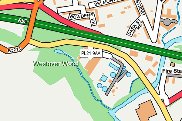
PL21 9AA is located in the Ivybridge West electoral ward, within the local authority district of South Hams and the English Parliamentary constituency of South West Devon. The Sub Integrated Care Board (ICB) Location is NHS Devon ICB - 15N and the police force is Devon & Cornwall. This postcode has been in use since January 1980.


GetTheData
Source: OS OpenMap – Local (Ordnance Survey)
Source: OS VectorMap District (Ordnance Survey)
Licence: Open Government Licence (requires attribution)
| Easting | 263061 |
| Northing | 55714 |
| Latitude | 50.385326 |
| Longitude | -3.927569 |
GetTheData
Source: Open Postcode Geo
Licence: Open Government Licence
| Country | England |
| Postcode District | PL21 |
| ➜ PL21 open data dashboard ➜ See where PL21 is on a map ➜ Where is Ivybridge? | |
GetTheData
Source: Land Registry Price Paid Data
Licence: Open Government Licence
Elevation or altitude of PL21 9AA as distance above sea level:
| Metres | Feet | |
|---|---|---|
| Elevation | 40m | 131ft |
Elevation is measured from the approximate centre of the postcode, to the nearest point on an OS contour line from OS Terrain 50, which has contour spacing of ten vertical metres.
➜ How high above sea level am I? Find the elevation of your current position using your device's GPS.
GetTheData
Source: Open Postcode Elevation
Licence: Open Government Licence
| Ward | Ivybridge West |
| Constituency | South West Devon |
GetTheData
Source: ONS Postcode Database
Licence: Open Government Licence
| October 2022 | Violence and sexual offences | On or near Greenwood Close | 313m |
| September 2022 | Anti-social behaviour | On or near Greenwood Close | 313m |
| June 2022 | Criminal damage and arson | On or near Clare Street | 329m |
| ➜ Get more crime data in our Crime section | |||
GetTheData
Source: data.police.uk
Licence: Open Government Licence
| Westover Wood (B3213) | Ivybridge | 165m |
| Wayside (Western Road) | Ivybridge | 240m |
| Rose Cottage (Western Road) | Ivybridge | 244m |
| Community Centre (B3211) | Ivybridge | 318m |
| Ermington Road (B3211) | Ivybridge | 321m |
| Ivybridge Station | 1.9km |
GetTheData
Source: NaPTAN
Licence: Open Government Licence
GetTheData
Source: ONS Postcode Database
Licence: Open Government Licence


➜ Get more ratings from the Food Standards Agency
GetTheData
Source: Food Standards Agency
Licence: FSA terms & conditions
| Last Collection | |||
|---|---|---|---|
| Location | Mon-Fri | Sat | Distance |
| Fore Street | 18:15 | 12:45 | 557m |
| Board School | 16:30 | 12:00 | 893m |
| Abbots Court Post Office | 18:30 | 12:30 | 1,129m |
GetTheData
Source: Dracos
Licence: Creative Commons Attribution-ShareAlike
| Facility | Distance |
|---|---|
| South Devon Tennis Centre Ermington Road, Ivybridge Indoor Tennis Centre, Outdoor Tennis Courts | 247m |
| Erme Playing Fields Ermington Road, Ivybridge Grass Pitches | 332m |
| Manor Primary School Manor Way, Ivybridge Swimming Pool, Grass Pitches | 419m |
GetTheData
Source: Active Places
Licence: Open Government Licence
| School | Phase of Education | Distance |
|---|---|---|
| Manor Primary School, Ivybridge Manor Way, Ivybridge, PL21 9BG | Primary | 419m |
| Woodlands Park Primary School Abbot Road, Ivybridge, PL21 9TF | Primary | 915m |
| The Erme Primary School Station Road, Ivybridge, PL21 0AJ | Primary | 918m |
GetTheData
Source: Edubase
Licence: Open Government Licence
The below table lists the International Territorial Level (ITL) codes (formerly Nomenclature of Territorial Units for Statistics (NUTS) codes) and Local Administrative Units (LAU) codes for PL21 9AA:
| ITL 1 Code | Name |
|---|---|
| TLK | South West (England) |
| ITL 2 Code | Name |
| TLK4 | Devon |
| ITL 3 Code | Name |
| TLK43 | Devon CC |
| LAU 1 Code | Name |
| E07000044 | South Hams |
GetTheData
Source: ONS Postcode Directory
Licence: Open Government Licence
The below table lists the Census Output Area (OA), Lower Layer Super Output Area (LSOA), and Middle Layer Super Output Area (MSOA) for PL21 9AA:
| Code | Name | |
|---|---|---|
| OA | E00102104 | |
| LSOA | E01020161 | South Hams 005A |
| MSOA | E02004193 | South Hams 005 |
GetTheData
Source: ONS Postcode Directory
Licence: Open Government Licence
| PL21 9EH | Park Street Mews | 167m |
| PL21 9PR | Bowdens Park | 169m |
| PL21 9DS | Belmont Road | 201m |
| PL21 9DP | Park Street | 206m |
| PL21 9DT | Belmont Road | 217m |
| PL21 9AT | Western Road | 221m |
| PL21 9DW | Park Street | 228m |
| PL21 9AS | Kimberley Villas | 229m |
| PL21 9AR | Belmont Villas | 240m |
| PL21 9DF | Waterside Row | 245m |
GetTheData
Source: Open Postcode Geo; Land Registry Price Paid Data
Licence: Open Government Licence