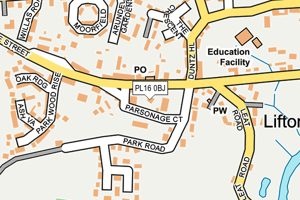
PL16 0BJ lies on Parsonage Court in Lifton. PL16 0BJ is located in the Tamarside electoral ward, within the local authority district of West Devon and the English Parliamentary constituency of Torridge and West Devon. The Sub Integrated Care Board (ICB) Location is NHS Devon ICB - 15N and the police force is Devon & Cornwall. This postcode has been in use since January 1980.


GetTheData
Source: OS OpenMap – Local (Ordnance Survey)
Source: OS VectorMap District (Ordnance Survey)
Licence: Open Government Licence (requires attribution)
| Easting | 238655 |
| Northing | 85068 |
| Latitude | 50.642905 |
| Longitude | -4.283300 |
GetTheData
Source: Open Postcode Geo
Licence: Open Government Licence
| Street | Parsonage Court |
| Town/City | Lifton |
| Country | England |
| Postcode District | PL16 |
| ➜ PL16 open data dashboard ➜ See where PL16 is on a map ➜ Where is Lifton? | |
GetTheData
Source: Land Registry Price Paid Data
Licence: Open Government Licence
Elevation or altitude of PL16 0BJ as distance above sea level:
| Metres | Feet | |
|---|---|---|
| Elevation | 80m | 262ft |
Elevation is measured from the approximate centre of the postcode, to the nearest point on an OS contour line from OS Terrain 50, which has contour spacing of ten vertical metres.
➜ How high above sea level am I? Find the elevation of your current position using your device's GPS.
GetTheData
Source: Open Postcode Elevation
Licence: Open Government Licence
| Ward | Tamarside |
| Constituency | Torridge And West Devon |
GetTheData
Source: ONS Postcode Database
Licence: Open Government Licence
| June 2022 | Violence and sexual offences | On or near Oak Ridge | 233m |
| April 2022 | Violence and sexual offences | On or near Arundell Gardens | 184m |
| March 2022 | Violence and sexual offences | On or near Arundell Close | 143m |
| ➜ Parsonage Court crime map and outcomes | |||
GetTheData
Source: data.police.uk
Licence: Open Government Licence
| Arundell Arms Hotel (Fore Street) | Lifton | 36m |
| Arundell Arms Hotel (Fore Street) | Lifton | 75m |
| The Crescent | Lifton | 136m |
| The Crescent | Lifton | 141m |
| Fox And Grapes (Tinhay Court) | Lifton | 773m |
GetTheData
Source: NaPTAN
Licence: Open Government Licence
| Percentage of properties with Next Generation Access | 100.0% |
| Percentage of properties with Superfast Broadband | 100.0% |
| Percentage of properties with Ultrafast Broadband | 0.0% |
| Percentage of properties with Full Fibre Broadband | 0.0% |
Superfast Broadband is between 30Mbps and 300Mbps
Ultrafast Broadband is > 300Mbps
| Percentage of properties unable to receive 2Mbps | 0.0% |
| Percentage of properties unable to receive 5Mbps | 0.0% |
| Percentage of properties unable to receive 10Mbps | 0.0% |
| Percentage of properties unable to receive 30Mbps | 0.0% |
GetTheData
Source: Ofcom
Licence: Ofcom Terms of Use (requires attribution)
GetTheData
Source: ONS Postcode Database
Licence: Open Government Licence


➜ Get more ratings from the Food Standards Agency
GetTheData
Source: Food Standards Agency
Licence: FSA terms & conditions
| Last Collection | |||
|---|---|---|---|
| Location | Mon-Fri | Sat | Distance |
| Albert Cotts (Milton Abbot) | 10:00 | 10:00 | 4,065m |
| Bradstone | 10:00 | 10:00 | 4,345m |
| Felldownhead | 10:00 | 10:00 | 5,030m |
GetTheData
Source: Dracos
Licence: Creative Commons Attribution-ShareAlike
| Facility | Distance |
|---|---|
| Lifton Community Centre Park Wood Rise, Park Wood Rise, Lifton Sports Hall | 168m |
| Lifton Qeii Recreation Ground Leat Road, Lifton Grass Pitches | 427m |
| Polson Bridge Launceston Grass Pitches | 3.3km |
GetTheData
Source: Active Places
Licence: Open Government Licence
| School | Phase of Education | Distance |
|---|---|---|
| Lifton Community Academy North Road, Lifton, PL16 0EH | Primary | 226m |
| Launceston Primary School Long Field Road, Launceston, PL15 9FW | Primary | 5.2km |
GetTheData
Source: Edubase
Licence: Open Government Licence
The below table lists the International Territorial Level (ITL) codes (formerly Nomenclature of Territorial Units for Statistics (NUTS) codes) and Local Administrative Units (LAU) codes for PL16 0BJ:
| ITL 1 Code | Name |
|---|---|
| TLK | South West (England) |
| ITL 2 Code | Name |
| TLK4 | Devon |
| ITL 3 Code | Name |
| TLK43 | Devon CC |
| LAU 1 Code | Name |
| E07000047 | West Devon |
GetTheData
Source: ONS Postcode Directory
Licence: Open Government Licence
The below table lists the Census Output Area (OA), Lower Layer Super Output Area (LSOA), and Middle Layer Super Output Area (MSOA) for PL16 0BJ:
| Code | Name | |
|---|---|---|
| OA | E00103055 | |
| LSOA | E01020340 | West Devon 004D |
| MSOA | E02004232 | West Devon 004 |
GetTheData
Source: ONS Postcode Directory
Licence: Open Government Licence
| PL16 0AA | Fore Street | 44m |
| PL16 0BW | Church View | 62m |
| PL16 0BH | Fore Street | 71m |
| PL16 0BL | Park Road | 74m |
| PL16 0BP | Broad Street | 75m |
| PL16 0AD | Duntz Hill | 93m |
| PL16 0DP | Arundell Close | 129m |
| PL16 0DS | North Road | 142m |
| PL16 0BS | Park View | 150m |
| PL16 0BE | Hornapark Close | 172m |
GetTheData
Source: Open Postcode Geo; Land Registry Price Paid Data
Licence: Open Government Licence