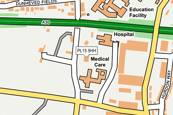
PL15 9HH is located in the Launceston South electoral ward, within the unitary authority of Cornwall and the English Parliamentary constituency of North Cornwall. The Sub Integrated Care Board (ICB) Location is NHS Cornwall and the Isles of Scilly ICB - 11N and the police force is Devon & Cornwall. This postcode has been in use since August 1992.


GetTheData
Source: OS OpenMap – Local (Ordnance Survey)
Source: OS VectorMap District (Ordnance Survey)
Licence: Open Government Licence (requires attribution)
| Easting | 233178 |
| Northing | 83544 |
| Latitude | 50.627668 |
| Longitude | -4.360007 |
GetTheData
Source: Open Postcode Geo
Licence: Open Government Licence
| Country | England |
| Postcode District | PL15 |
| ➜ PL15 open data dashboard ➜ See where PL15 is on a map ➜ Where is Launceston? | |
GetTheData
Source: Land Registry Price Paid Data
Licence: Open Government Licence
Elevation or altitude of PL15 9HH as distance above sea level:
| Metres | Feet | |
|---|---|---|
| Elevation | 150m | 492ft |
Elevation is measured from the approximate centre of the postcode, to the nearest point on an OS contour line from OS Terrain 50, which has contour spacing of ten vertical metres.
➜ How high above sea level am I? Find the elevation of your current position using your device's GPS.
GetTheData
Source: Open Postcode Elevation
Licence: Open Government Licence
| Ward | Launceston South |
| Constituency | North Cornwall |
GetTheData
Source: ONS Postcode Database
Licence: Open Government Licence
| June 2022 | Violence and sexual offences | On or near Hospital | 91m |
| June 2022 | Violence and sexual offences | On or near Hospital | 91m |
| June 2022 | Violence and sexual offences | On or near Hospital | 91m |
| ➜ Get more crime data in our Crime section | |||
GetTheData
Source: data.police.uk
Licence: Open Government Licence
| Landlake Road | Scarne Industrial Estate | 147m |
| Launceston Hospital (Link Road) | Scarne Industrial Estate | 159m |
| Launceston Hospital (Link Road) | Scarne Industrial Estate | 162m |
| Hurdon Road | Scarne Industrial Estate | 215m |
| Hurdon Road | Scarne Industrial Estate | 227m |
GetTheData
Source: NaPTAN
Licence: Open Government Licence
GetTheData
Source: ONS Postcode Database
Licence: Open Government Licence


➜ Get more ratings from the Food Standards Agency
GetTheData
Source: Food Standards Agency
Licence: FSA terms & conditions
| Last Collection | |||
|---|---|---|---|
| Location | Mon-Fri | Sat | Distance |
| Lanstephan | 17:15 | 10:15 | 4,236m |
| Kennards House | 10:30 | 10:30 | 4,370m |
| Felldownhead | 10:00 | 10:00 | 5,672m |
GetTheData
Source: Dracos
Licence: Creative Commons Attribution-ShareAlike
| Facility | Distance |
|---|---|
| Launceston College Playing Fields Landlake Road, Launceston Grass Pitches, Artificial Grass Pitch, Outdoor Tennis Courts | 143m |
| Launceston College Hurdon Road, Launceston Sports Hall | 217m |
| Launceston Community Leisure Centre Coronation Park, Launceston Sports Hall, Swimming Pool, Health and Fitness Gym, Squash Courts, Studio | 415m |
GetTheData
Source: Active Places
Licence: Open Government Licence
| School | Phase of Education | Distance |
|---|---|---|
| Launceston College Hurdon Road, Launceston, PL15 9JR | Secondary | 313m |
| Launceston Primary School Long Field Road, Launceston, PL15 9FW | Primary | 531m |
| Windmill Hill Academy Windmill Hill, Launceston, PL15 9AE | Primary | 752m |
GetTheData
Source: Edubase
Licence: Open Government Licence
The below table lists the International Territorial Level (ITL) codes (formerly Nomenclature of Territorial Units for Statistics (NUTS) codes) and Local Administrative Units (LAU) codes for PL15 9HH:
| ITL 1 Code | Name |
|---|---|
| TLK | South West (England) |
| ITL 2 Code | Name |
| TLK3 | Cornwall and Isles of Scilly |
| ITL 3 Code | Name |
| TLK30 | Cornwall and Isles of Scilly |
| LAU 1 Code | Name |
| E06000052 | Cornwall |
GetTheData
Source: ONS Postcode Directory
Licence: Open Government Licence
The below table lists the Census Output Area (OA), Lower Layer Super Output Area (LSOA), and Middle Layer Super Output Area (MSOA) for PL15 9HH:
| Code | Name | |
|---|---|---|
| OA | E00095693 | |
| LSOA | E01018947 | Cornwall 005B |
| MSOA | E02003935 | Cornwall 005 |
GetTheData
Source: ONS Postcode Directory
Licence: Open Government Licence
| PL15 9HP | Landlake Road | 62m |
| PL15 9HZ | Badash Cottages | 154m |
| PL15 9JJ | Dunheved Road | 175m |
| PL15 9JH | Dunheved Road | 175m |
| PL15 7HS | Dunheved Fields | 266m |
| PL15 9HU | Hurdon Way | 283m |
| PL15 9HX | Hurdon Way | 310m |
| PL15 9HY | Hurdon Way | 323m |
| PL15 7HF | Hendra Vale | 324m |
| PL15 9DQ | Coronation Park | 339m |
GetTheData
Source: Open Postcode Geo; Land Registry Price Paid Data
Licence: Open Government Licence