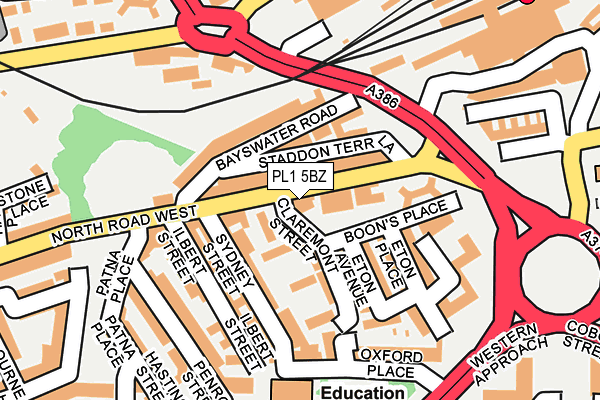
PL1 5BZ is located in the St Peter and the Waterfront electoral ward, within the unitary authority of Plymouth and the English Parliamentary constituency of Plymouth, Sutton and Devonport. The Sub Integrated Care Board (ICB) Location is NHS Devon ICB - 15N and the police force is Devon & Cornwall. This postcode has been in use since January 1980.


GetTheData
Source: OS OpenMap – Local (Ordnance Survey)
Source: OS VectorMap District (Ordnance Survey)
Licence: Open Government Licence (requires attribution)
| Easting | 247485 |
| Northing | 55110 |
| Latitude | 50.376062 |
| Longitude | -4.146265 |
GetTheData
Source: Open Postcode Geo
Licence: Open Government Licence
| Country | England |
| Postcode District | PL1 |
| ➜ PL1 open data dashboard ➜ See where PL1 is on a map ➜ Where is Plymouth? | |
GetTheData
Source: Land Registry Price Paid Data
Licence: Open Government Licence
Elevation or altitude of PL1 5BZ as distance above sea level:
| Metres | Feet | |
|---|---|---|
| Elevation | 20m | 66ft |
Elevation is measured from the approximate centre of the postcode, to the nearest point on an OS contour line from OS Terrain 50, which has contour spacing of ten vertical metres.
➜ How high above sea level am I? Find the elevation of your current position using your device's GPS.
GetTheData
Source: Open Postcode Elevation
Licence: Open Government Licence
| Ward | St Peter And The Waterfront |
| Constituency | Plymouth, Sutton And Devonport |
GetTheData
Source: ONS Postcode Database
Licence: Open Government Licence
| October 2022 | Anti-social behaviour | On or near Cornwall Street | 449m |
| October 2022 | Anti-social behaviour | On or near Cornwall Street | 449m |
| October 2022 | Anti-social behaviour | On or near Cornwall Street | 449m |
| ➜ Get more crime data in our Crime section | |||
GetTheData
Source: data.police.uk
Licence: Open Government Licence
| Sydney Street | Pennycomequick | 77m |
| Railway Station (Pennycomequick Hill) | Pennycomequick | 124m |
| Railway Station | Pennycomequick | 154m |
| Pennycomequick (Pennycomequick Hill) | Pennycomequick | 168m |
| Railway Station Forecourt | Pennycomequick | 196m |
| Plymouth Station | 0.3km |
| Devonport Station | 1.8km |
| Dockyard (Plymouth) Station | 2.2km |
GetTheData
Source: NaPTAN
Licence: Open Government Licence
GetTheData
Source: ONS Postcode Database
Licence: Open Government Licence


➜ Get more ratings from the Food Standards Agency
GetTheData
Source: Food Standards Agency
Licence: FSA terms & conditions
| Last Collection | |||
|---|---|---|---|
| Location | Mon-Fri | Sat | Distance |
| North Road West | 17:30 | 12:00 | 97m |
| Oxford Place | 17:30 | 12:00 | 188m |
| Plymouth Station | 17:45 | 12:15 | 224m |
GetTheData
Source: Dracos
Licence: Creative Commons Attribution-ShareAlike
| Facility | Distance |
|---|---|
| Le Club At Copthorne Hotel Plymouth (Closed) Armada Way, Plymouth Health and Fitness Gym, Swimming Pool | 292m |
| Ymca (Plymouth Triangle Centre) (Closed) Cobourg Street, Plymouth Studio, Health and Fitness Gym | 442m |
| Fletewood School North Road East, Plymouth Sports Hall | 470m |
GetTheData
Source: Active Places
Licence: Open Government Licence
| School | Phase of Education | Distance |
|---|---|---|
| Pilgrim Primary Academy Oxford Street, Plymouth, PL1 5BQ | Primary | 187m |
| The Cathedral School of St Mary Cecil Street, Stonehouse, Plymouth, PL1 5HW | Primary | 461m |
| Fletewood School at Derry Villas 88 North Road East, Plymouth, PL4 6AN | Not applicable | 470m |
GetTheData
Source: Edubase
Licence: Open Government Licence
The below table lists the International Territorial Level (ITL) codes (formerly Nomenclature of Territorial Units for Statistics (NUTS) codes) and Local Administrative Units (LAU) codes for PL1 5BZ:
| ITL 1 Code | Name |
|---|---|
| TLK | South West (England) |
| ITL 2 Code | Name |
| TLK4 | Devon |
| ITL 3 Code | Name |
| TLK41 | Plymouth |
| LAU 1 Code | Name |
| E06000026 | Plymouth |
GetTheData
Source: ONS Postcode Directory
Licence: Open Government Licence
The below table lists the Census Output Area (OA), Lower Layer Super Output Area (LSOA), and Middle Layer Super Output Area (MSOA) for PL1 5BZ:
| Code | Name | |
|---|---|---|
| OA | E00076542 | |
| LSOA | E01015152 | Plymouth 027C |
| MSOA | E02003148 | Plymouth 027 |
GetTheData
Source: ONS Postcode Directory
Licence: Open Government Licence
| PL1 5BY | North Road West | 35m |
| PL1 5AQ | Claremont Street | 50m |
| PL1 5BX | Bayswater Road | 63m |
| PL1 5DE | North Road West | 65m |
| PL1 5AG | Claremont Street | 69m |
| PL1 5DL | Staddon Terrace Lane | 78m |
| PL1 5BU | Bayswater Road | 88m |
| PL1 5AE | Sydney Street | 88m |
| PL1 5DP | Eton Avenue | 93m |
| PL1 5DW | Boons Place | 108m |
GetTheData
Source: Open Postcode Geo; Land Registry Price Paid Data
Licence: Open Government Licence