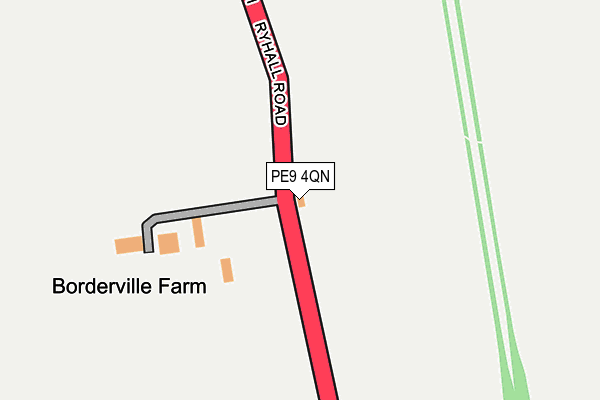
PE9 4QN is located in the Stamford St George's electoral ward, within the local authority district of South Kesteven and the English Parliamentary constituency of Grantham and Stamford. The Sub Integrated Care Board (ICB) Location is NHS Lincolnshire ICB - 71E and the police force is Lincolnshire. This postcode has been in use since January 1980.


GetTheData
Source: OS OpenMap – Local (Ordnance Survey)
Source: OS VectorMap District (Ordnance Survey)
Licence: Open Government Licence (requires attribution)
| Easting | 503681 |
| Northing | 308950 |
| Latitude | 52.668355 |
| Longitude | -0.468223 |
GetTheData
Source: Open Postcode Geo
Licence: Open Government Licence
| Country | England |
| Postcode District | PE9 |
| ➜ PE9 open data dashboard ➜ See where PE9 is on a map | |
GetTheData
Source: Land Registry Price Paid Data
Licence: Open Government Licence
Elevation or altitude of PE9 4QN as distance above sea level:
| Metres | Feet | |
|---|---|---|
| Elevation | 30m | 98ft |
Elevation is measured from the approximate centre of the postcode, to the nearest point on an OS contour line from OS Terrain 50, which has contour spacing of ten vertical metres.
➜ How high above sea level am I? Find the elevation of your current position using your device's GPS.
GetTheData
Source: Open Postcode Elevation
Licence: Open Government Licence
| Ward | Stamford St George's |
| Constituency | Grantham And Stamford |
GetTheData
Source: ONS Postcode Database
Licence: Open Government Licence
| June 2022 | Bicycle theft | On or near Guash Way | 461m |
| May 2022 | Vehicle crime | On or near Guash Way | 461m |
| April 2022 | Other theft | On or near Turnpole Close | 494m |
| ➜ Get more crime data in our Crime section | |||
GetTheData
Source: data.police.uk
Licence: Open Government Licence
| Guash Way (Ryhall Road) | Stamford | 468m |
| Guash Way (Ryhall Road) | Stamford | 526m |
| Bowling Green (Lincoln Road) | Stamford | 812m |
| Bowling Green (Lincoln Road) | Stamford | 832m |
| Stamford Free Church (Kesteven Road) | Stamford | 872m |
| Stamford Station | 2.4km |
GetTheData
Source: NaPTAN
Licence: Open Government Licence
| Percentage of properties with Next Generation Access | 100.0% |
| Percentage of properties with Superfast Broadband | 100.0% |
| Percentage of properties with Ultrafast Broadband | 0.0% |
| Percentage of properties with Full Fibre Broadband | 0.0% |
Superfast Broadband is between 30Mbps and 300Mbps
Ultrafast Broadband is > 300Mbps
| Percentage of properties unable to receive 2Mbps | 0.0% |
| Percentage of properties unable to receive 5Mbps | 0.0% |
| Percentage of properties unable to receive 10Mbps | 0.0% |
| Percentage of properties unable to receive 30Mbps | 0.0% |
GetTheData
Source: Ofcom
Licence: Ofcom Terms of Use (requires attribution)
GetTheData
Source: ONS Postcode Database
Licence: Open Government Licence


➜ Get more ratings from the Food Standards Agency
GetTheData
Source: Food Standards Agency
Licence: FSA terms & conditions
| Last Collection | |||
|---|---|---|---|
| Location | Mon-Fri | Sat | Distance |
| Doughty Street | 17:30 | 10:45 | 773m |
| Kesteven Road Post Office | 17:30 | 10:50 | 886m |
| Drift Estate | 17:30 | 10:45 | 1,072m |
GetTheData
Source: Dracos
Licence: Creative Commons Attribution-ShareAlike
| Facility | Distance |
|---|---|
| Borderville Sports Centre Ryhall Road, Stamford Sports Hall, Artificial Grass Pitch, Grass Pitches, Health and Fitness Gym | 280m |
| Rhino's Gymnasium Gwash Way Industrial Estate, Ryhall Road, Stamford Health and Fitness Gym, Studio | 464m |
| Blackstone Sports And Social Club Lincoln Road, Stamford Grass Pitches | 756m |
GetTheData
Source: Active Places
Licence: Open Government Licence
| School | Phase of Education | Distance |
|---|---|---|
| St George's Church of England Aided Primary School Kesteven Road, Stamford, PE9 1SX | Primary | 858m |
| St Augustine's Catholic Voluntary Academy Kesteven Road, Stamford, PE9 1SR | Primary | 930m |
| Stamford Welland Academy Green Lane, Stamford Welland Academy, Stamford, PE9 1HE | Secondary | 1.3km |
GetTheData
Source: Edubase
Licence: Open Government Licence
The below table lists the International Territorial Level (ITL) codes (formerly Nomenclature of Territorial Units for Statistics (NUTS) codes) and Local Administrative Units (LAU) codes for PE9 4QN:
| ITL 1 Code | Name |
|---|---|
| TLF | East Midlands (England) |
| ITL 2 Code | Name |
| TLF3 | Lincolnshire |
| ITL 3 Code | Name |
| TLF30 | Lincolnshire CC |
| LAU 1 Code | Name |
| E07000141 | South Kesteven |
GetTheData
Source: ONS Postcode Directory
Licence: Open Government Licence
The below table lists the Census Output Area (OA), Lower Layer Super Output Area (LSOA), and Middle Layer Super Output Area (MSOA) for PE9 4QN:
| Code | Name | |
|---|---|---|
| OA | E00133830 | |
| LSOA | E01026346 | South Kesteven 015D |
| MSOA | E02005490 | South Kesteven 015 |
GetTheData
Source: ONS Postcode Directory
Licence: Open Government Licence
| PE9 1DT | Turnpole Close | 462m |
| PE9 1DU | Losecoat Close | 462m |
| PE9 1UW | Rutland Road | 531m |
| PE9 1DS | Berrybut Way | 558m |
| PE9 1DR | Armley Grove | 573m |
| PE9 1DP | Woodhead Close | 629m |
| PE9 1UL | Ryhall Road | 646m |
| PE9 1SN | Masterton Road | 658m |
| PE9 1UP | Rutland Road | 665m |
| PE9 1SW | Glen Crescent | 712m |
GetTheData
Source: Open Postcode Geo; Land Registry Price Paid Data
Licence: Open Government Licence