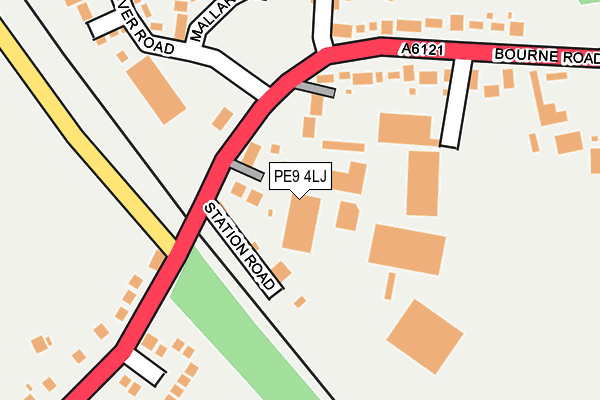
PE9 4LJ is located in the Ryhall & Casterton electoral ward, within the unitary authority of Rutland and the English Parliamentary constituency of Rutland and Melton. The Sub Integrated Care Board (ICB) Location is NHS Leicester, Leicestershire and Rutland ICB - 03W and the police force is Leicestershire. This postcode has been in use since January 2005.


GetTheData
Source: OS OpenMap – Local (Ordnance Survey)
Source: OS VectorMap District (Ordnance Survey)
Licence: Open Government Licence (requires attribution)
| Easting | 504663 |
| Northing | 312556 |
| Latitude | 52.700572 |
| Longitude | -0.452562 |
GetTheData
Source: Open Postcode Geo
Licence: Open Government Licence
| Country | England |
| Postcode District | PE9 |
| ➜ PE9 open data dashboard ➜ See where PE9 is on a map ➜ Where is Essendine? | |
GetTheData
Source: Land Registry Price Paid Data
Licence: Open Government Licence
Elevation or altitude of PE9 4LJ as distance above sea level:
| Metres | Feet | |
|---|---|---|
| Elevation | 30m | 98ft |
Elevation is measured from the approximate centre of the postcode, to the nearest point on an OS contour line from OS Terrain 50, which has contour spacing of ten vertical metres.
➜ How high above sea level am I? Find the elevation of your current position using your device's GPS.
GetTheData
Source: Open Postcode Elevation
Licence: Open Government Licence
| Ward | Ryhall & Casterton |
| Constituency | Rutland And Melton |
GetTheData
Source: ONS Postcode Database
Licence: Open Government Licence
| June 2022 | Burglary | On or near Station Road | 78m |
| June 2022 | Violence and sexual offences | On or near Manor Farm Lane | 341m |
| April 2022 | Vehicle crime | On or near Station Road | 78m |
| ➜ Get more crime data in our Crime section | |||
GetTheData
Source: data.police.uk
Licence: Open Government Licence
| Village Hall (Stamford Road) | Essendine | 84m |
| Village Hall (Stamford Road) | Essendine | 100m |
| Former Railway Cutting (Greatford Road) | Carlby | 1,168m |
| Former Railway Cutting (Greatford Road) | Carlby | 1,188m |
| Bus Dept (A6121) | Ryhall | 1,198m |
GetTheData
Source: NaPTAN
Licence: Open Government Licence
GetTheData
Source: ONS Postcode Database
Licence: Open Government Licence


➜ Get more ratings from the Food Standards Agency
GetTheData
Source: Food Standards Agency
Licence: FSA terms & conditions
| Last Collection | |||
|---|---|---|---|
| Location | Mon-Fri | Sat | Distance |
| Essendine Post Office | 16:00 | 08:30 | 162m |
| Carlby | 16:00 | 09:30 | 1,460m |
| Mill Street | 16:20 | 09:15 | 1,758m |
GetTheData
Source: Dracos
Licence: Creative Commons Attribution-ShareAlike
| Facility | Distance |
|---|---|
| Meadow Playing Fields Parkfield Road, Ryhall, Stamford Grass Pitches, Outdoor Tennis Courts | 2.1km |
| Ryhall Church Of England Academy Church Street, Church Street, Ryhall, Stamford Grass Pitches | 2.1km |
| Borderville Sports Centre Ryhall Road, Stamford Sports Hall, Artificial Grass Pitch, Grass Pitches, Health and Fitness Gym | 4km |
GetTheData
Source: Active Places
Licence: Open Government Licence
| School | Phase of Education | Distance |
|---|---|---|
| Ryhall CofE Academy Church Street, Ryhall, Stamford, PE9 4HR | Primary | 2.1km |
| Witham Hall School Witham-on-the-Hill, Bourne, PE10 0JJ | Not applicable | 4.2km |
| St George's Church of England Aided Primary School Kesteven Road, Stamford, PE9 1SX | Primary | 4.6km |
GetTheData
Source: Edubase
Licence: Open Government Licence
The below table lists the International Territorial Level (ITL) codes (formerly Nomenclature of Territorial Units for Statistics (NUTS) codes) and Local Administrative Units (LAU) codes for PE9 4LJ:
| ITL 1 Code | Name |
|---|---|
| TLF | East Midlands (England) |
| ITL 2 Code | Name |
| TLF2 | Leicestershire, Rutland and Northamptonshire |
| ITL 3 Code | Name |
| TLF22 | Leicestershire CC and Rutland |
| LAU 1 Code | Name |
| E06000017 | Rutland |
GetTheData
Source: ONS Postcode Directory
Licence: Open Government Licence
The below table lists the Census Output Area (OA), Lower Layer Super Output Area (LSOA), and Middle Layer Super Output Area (MSOA) for PE9 4LJ:
| Code | Name | |
|---|---|---|
| OA | E00069633 | |
| LSOA | E01013804 | Rutland 004D |
| MSOA | E02002866 | Rutland 004 |
GetTheData
Source: ONS Postcode Directory
Licence: Open Government Licence
| PE9 4LF | Station Road | 67m |
| PE9 4LG | Stamford Road | 156m |
| PE9 4LH | Bourne Road | 177m |
| PE9 4LP | Glen Crescent | 227m |
| PE9 4UP | Mallard Close | 234m |
| PE9 4UU | Dunlin Road | 263m |
| PE9 4UT | Avocet Close | 286m |
| PE9 4LQ | Stamford Road | 312m |
| PE9 4UR | Plover Road | 314m |
| PE9 4LA | Manor Farm Lane | 386m |
GetTheData
Source: Open Postcode Geo; Land Registry Price Paid Data
Licence: Open Government Licence