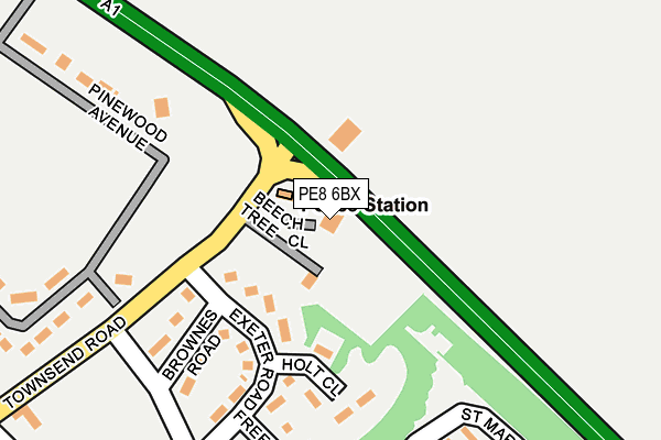
PE8 6BX is located in the Wittering electoral ward, within the unitary authority of Peterborough and the English Parliamentary constituency of North West Cambridgeshire. The Sub Integrated Care Board (ICB) Location is NHS Cambridgeshire and Peterborough ICB - 06H and the police force is Cambridgeshire. This postcode has been in use since July 2009.


GetTheData
Source: OS OpenMap – Local (Ordnance Survey)
Source: OS VectorMap District (Ordnance Survey)
Licence: Open Government Licence (requires attribution)
| Easting | 505769 |
| Northing | 302729 |
| Latitude | 52.612067 |
| Longitude | -0.439337 |
GetTheData
Source: Open Postcode Geo
Licence: Open Government Licence
| Country | England |
| Postcode District | PE8 |
| ➜ PE8 open data dashboard ➜ See where PE8 is on a map ➜ Where is Wittering? | |
GetTheData
Source: Land Registry Price Paid Data
Licence: Open Government Licence
Elevation or altitude of PE8 6BX as distance above sea level:
| Metres | Feet | |
|---|---|---|
| Elevation | 60m | 197ft |
Elevation is measured from the approximate centre of the postcode, to the nearest point on an OS contour line from OS Terrain 50, which has contour spacing of ten vertical metres.
➜ How high above sea level am I? Find the elevation of your current position using your device's GPS.
GetTheData
Source: Open Postcode Elevation
Licence: Open Government Licence
| Ward | Wittering |
| Constituency | North West Cambridgeshire |
GetTheData
Source: ONS Postcode Database
Licence: Open Government Licence
| June 2022 | Violence and sexual offences | On or near Harvey Close | 361m |
| June 2022 | Violence and sexual offences | On or near The Limes | 431m |
| June 2022 | Violence and sexual offences | On or near The Limes | 431m |
| ➜ Get more crime data in our Crime section | |||
GetTheData
Source: data.police.uk
Licence: Open Government Licence
| Exeter Road (Burghley Avenue) | Wittering | 254m |
| Spar Shop (St Georges Road) | Wittering | 416m |
| Post Office (Townsend Road) | Wittering | 473m |
| Parker Road | Wittering | 629m |
| Church Road | Wittering | 637m |
| Stamford Station | 4.8km |
GetTheData
Source: NaPTAN
Licence: Open Government Licence
GetTheData
Source: ONS Postcode Database
Licence: Open Government Licence


➜ Get more ratings from the Food Standards Agency
GetTheData
Source: Food Standards Agency
Licence: FSA terms & conditions
| Last Collection | |||
|---|---|---|---|
| Location | Mon-Fri | Sat | Distance |
| Southorpe | 16:45 | 09:30 | 2,533m |
| Walcott Hall | 16:45 | 10:00 | 2,745m |
| Barnack Road | 16:45 | 10:00 | 2,820m |
GetTheData
Source: Dracos
Licence: Creative Commons Attribution-ShareAlike
| Facility | Distance |
|---|---|
| Wittering Playing Field Townsend Road, Wittering, Peterborough Grass Pitches | 330m |
| Raf Wittering Wittering, Peterborough Athletics, Artificial Grass Pitch, Grass Pitches, Sports Hall, Studio, Squash Courts, Health and Fitness Gym | 576m |
| Barnack Cricket Club Walcot Road, Barnack Grass Pitches | 2.8km |
GetTheData
Source: Active Places
Licence: Open Government Licence
| School | Phase of Education | Distance |
|---|---|---|
| Wittering Primary School Church Road, Wittering, Peterborough, PE8 6AF | Primary | 580m |
| Barnack CofE (Controlled) Primary School School Road, Barnack, Stamford, PE9 3DZ | Primary | 3km |
| Copthill Independent Day School & Nursery Barnack Road, Uffington, Stamford, PE9 3AD | Not applicable | 4.4km |
GetTheData
Source: Edubase
Licence: Open Government Licence
The below table lists the International Territorial Level (ITL) codes (formerly Nomenclature of Territorial Units for Statistics (NUTS) codes) and Local Administrative Units (LAU) codes for PE8 6BX:
| ITL 1 Code | Name |
|---|---|
| TLH | East |
| ITL 2 Code | Name |
| TLH1 | East Anglia |
| ITL 3 Code | Name |
| TLH11 | Peterborough |
| LAU 1 Code | Name |
| E06000031 | Peterborough |
GetTheData
Source: ONS Postcode Directory
Licence: Open Government Licence
The below table lists the Census Output Area (OA), Lower Layer Super Output Area (LSOA), and Middle Layer Super Output Area (MSOA) for PE8 6BX:
| Code | Name | |
|---|---|---|
| OA | E00079044 | |
| LSOA | E01015626 | Peterborough 004C |
| MSOA | E02003240 | Peterborough 004 |
GetTheData
Source: ONS Postcode Directory
Licence: Open Government Licence
| PE8 6DF | Beech Tree Close | 39m |
| PE8 6BY | Silver Birch Court | 330m |
| PE8 6BD | Towns End Road | 330m |
| PE8 6DU | Park Farm | 365m |
| PE8 6DH | St Georges Road | 372m |
| PE8 6BH | Harvey Close | 373m |
| PE8 6DL | St Georges Road | 391m |
| PE8 6DJ | St Georges Road | 410m |
| PE8 6BQ | The Limes | 414m |
| PE8 6EB | Baldwin Close | 432m |
GetTheData
Source: Open Postcode Geo; Land Registry Price Paid Data
Licence: Open Government Licence