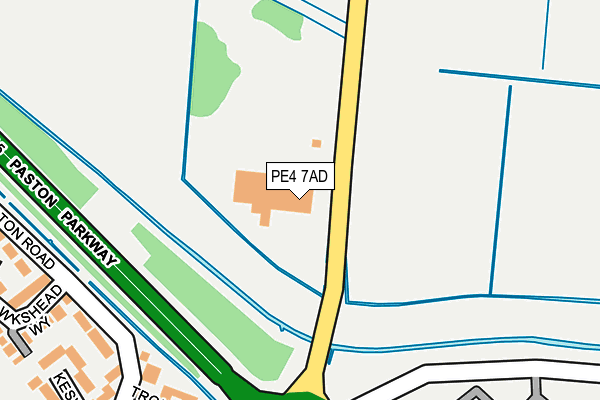
PE4 7AD is located in the Eye, Thorney and Newborough electoral ward, within the unitary authority of Peterborough and the English Parliamentary constituency of Peterborough. The Sub Integrated Care Board (ICB) Location is NHS Cambridgeshire and Peterborough ICB - 06H and the police force is Cambridgeshire. This postcode has been in use since February 1990.


GetTheData
Source: OS OpenMap – Local (Ordnance Survey)
Source: OS VectorMap District (Ordnance Survey)
Licence: Open Government Licence (requires attribution)
| Easting | 518764 |
| Northing | 303473 |
| Latitude | 52.616051 |
| Longitude | -0.247254 |
GetTheData
Source: Open Postcode Geo
Licence: Open Government Licence
| Country | England |
| Postcode District | PE4 |
| ➜ PE4 open data dashboard ➜ See where PE4 is on a map ➜ Where is Peterborough? | |
GetTheData
Source: Land Registry Price Paid Data
Licence: Open Government Licence
Elevation or altitude of PE4 7AD as distance above sea level:
| Metres | Feet | |
|---|---|---|
| Elevation | 0m | 0ft |
Elevation is measured from the approximate centre of the postcode, to the nearest point on an OS contour line from OS Terrain 50, which has contour spacing of ten vertical metres.
➜ How high above sea level am I? Find the elevation of your current position using your device's GPS.
GetTheData
Source: Open Postcode Elevation
Licence: Open Government Licence
| Ward | Eye, Thorney And Newborough |
| Constituency | Peterborough |
GetTheData
Source: ONS Postcode Database
Licence: Open Government Licence
| June 2022 | Criminal damage and arson | On or near Coniston Road | 320m |
| June 2022 | Vehicle crime | On or near Squires Gate | 417m |
| May 2022 | Anti-social behaviour | On or near Troutbeck Close | 262m |
| ➜ Get more crime data in our Crime section | |||
GetTheData
Source: data.police.uk
Licence: Open Government Licence
| Coniston Road | Gunthorpe | 269m |
| Coniston Road | Gunthorpe | 281m |
| Norwood School (Coniston Road) | Gunthorpe | 375m |
| Norwood School (Coniston Road) | Gunthorpe | 389m |
| Norwood School (Gunthorpe Road) | Gunthorpe | 437m |
| Peterborough Station | 4.6km |
GetTheData
Source: NaPTAN
Licence: Open Government Licence
GetTheData
Source: ONS Postcode Database
Licence: Open Government Licence


➜ Get more ratings from the Food Standards Agency
GetTheData
Source: Food Standards Agency
Licence: FSA terms & conditions
| Last Collection | |||
|---|---|---|---|
| Location | Mon-Fri | Sat | Distance |
| Gunthorpe Road Shops | 18:15 | 12:15 | 466m |
| Gunthorpe Ridings-kendal Close | 18:15 | 12:15 | 625m |
| Coniston Road Near Bala Court | 18:15 | 12:30 | 823m |
GetTheData
Source: Dracos
Licence: Creative Commons Attribution-ShareAlike
| Facility | Distance |
|---|---|
| Campbell Drive Campbell Drive, Peterborough Grass Pitches | 589m |
| Paston Ridings Primary School Paston Ridings, Peterborough Swimming Pool | 1.1km |
| The Voyager School Playing Fields (Closed) Brookside, Peterborough Grass Pitches | 1.4km |
GetTheData
Source: Active Places
Licence: Open Government Licence
| School | Phase of Education | Distance |
|---|---|---|
| Norwood Primary School Gunthorpe Road, Gunthorpe, Peterborough, PE4 7DZ | Primary | 453m |
| Gunthorpe Primary School The Pentlands, Hallfields Lane, Gunthorpe, Peterborough, PE4 7YP | Primary | 775m |
| Paston Ridings Primary School Paston Ridings, Paston, Peterborough, PE4 7XG | Primary | 1.1km |
GetTheData
Source: Edubase
Licence: Open Government Licence
The below table lists the International Territorial Level (ITL) codes (formerly Nomenclature of Territorial Units for Statistics (NUTS) codes) and Local Administrative Units (LAU) codes for PE4 7AD:
| ITL 1 Code | Name |
|---|---|
| TLH | East |
| ITL 2 Code | Name |
| TLH1 | East Anglia |
| ITL 3 Code | Name |
| TLH11 | Peterborough |
| LAU 1 Code | Name |
| E06000031 | Peterborough |
GetTheData
Source: ONS Postcode Directory
Licence: Open Government Licence
The below table lists the Census Output Area (OA), Lower Layer Super Output Area (LSOA), and Middle Layer Super Output Area (MSOA) for PE4 7AD:
| Code | Name | |
|---|---|---|
| OA | E00079048 | |
| LSOA | E01015630 | Peterborough 003A |
| MSOA | E02003239 | Peterborough 003 |
GetTheData
Source: ONS Postcode Directory
Licence: Open Government Licence
| PE4 7GU | Coniston Road | 251m |
| PE4 7JP | Troutbeck Close | 276m |
| PE4 7JN | Hawkshead Way | 309m |
| PE4 7JW | Keswick Close | 318m |
| PE4 7BT | Squires Gate | 370m |
| PE4 7JL | Eskdale Close | 392m |
| PE4 7YA | Borrowdale Close | 448m |
| PE4 7BU | Squires Gate | 465m |
| PE4 7TY | Elter Walk | 491m |
| PE4 7TZ | Elter Walk | 508m |
GetTheData
Source: Open Postcode Geo; Land Registry Price Paid Data
Licence: Open Government Licence