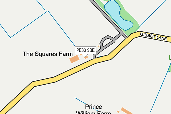
PE33 9BE is located in the Denver electoral ward, within the local authority district of King's Lynn and West Norfolk and the English Parliamentary constituency of South West Norfolk. The Sub Integrated Care Board (ICB) Location is NHS Norfolk and Waveney ICB - 26A and the police force is Norfolk. This postcode has been in use since January 1980.


GetTheData
Source: OS OpenMap – Local (Ordnance Survey)
Source: OS VectorMap District (Ordnance Survey)
Licence: Open Government Licence (requires attribution)
| Easting | 567824 |
| Northing | 302797 |
| Latitude | 52.597070 |
| Longitude | 0.476426 |
GetTheData
Source: Open Postcode Geo
Licence: Open Government Licence
| Country | England |
| Postcode District | PE33 |
| ➜ PE33 open data dashboard ➜ See where PE33 is on a map | |
GetTheData
Source: Land Registry Price Paid Data
Licence: Open Government Licence
Elevation or altitude of PE33 9BE as distance above sea level:
| Metres | Feet | |
|---|---|---|
| Elevation | 30m | 98ft |
Elevation is measured from the approximate centre of the postcode, to the nearest point on an OS contour line from OS Terrain 50, which has contour spacing of ten vertical metres.
➜ How high above sea level am I? Find the elevation of your current position using your device's GPS.
GetTheData
Source: Open Postcode Elevation
Licence: Open Government Licence
| Ward | Denver |
| Constituency | South West Norfolk |
GetTheData
Source: ONS Postcode Database
Licence: Open Government Licence
| School Lane (Church Road) | Wereham | 1,130m |
| School Lane (Church Road) | Wereham | 1,141m |
| Lime Kiln Road | West Dereham | 1,344m |
| Lime Kiln Road | West Dereham | 1,349m |
| Church Road (Stoke Road) | Wereham | 1,391m |
GetTheData
Source: NaPTAN
Licence: Open Government Licence
GetTheData
Source: ONS Postcode Database
Licence: Open Government Licence


➜ Get more ratings from the Food Standards Agency
GetTheData
Source: Food Standards Agency
Licence: FSA terms & conditions
| Last Collection | |||
|---|---|---|---|
| Location | Mon-Fri | Sat | Distance |
| Queens Close | 16:00 | 08:45 | 1,530m |
| Church Road | 16:00 | 09:00 | 1,666m |
| Boughton | 16:30 | 08:00 | 2,201m |
GetTheData
Source: Dracos
Licence: Creative Commons Attribution-ShareAlike
| Facility | Distance |
|---|---|
| The Playing Field (Closed) Church Road, Wereham, King's Lynn Grass Pitches | 1.1km |
| Peake Physique Therapy & Fitness Low Road, Wretton, King's Lynn Health and Fitness Gym | 3.4km |
| Stoke Ferry Playing Field Buckenham Drive, Stoke Ferry, King's Lynn Grass Pitches | 3.6km |
GetTheData
Source: Active Places
Licence: Open Government Licence
| School | Phase of Education | Distance |
|---|---|---|
| All Saints Academy Wretton Road, Stoke Ferry, King's Lynn, PE33 9QJ | Primary | 3.8km |
| Downham Preparatory School and Montessori Nursery The Old Rectory, Stow Bardolph, Nr King's Lynn, Norfolk, PE34 3HT | Not applicable | 5.7km |
GetTheData
Source: Edubase
Licence: Open Government Licence
The below table lists the International Territorial Level (ITL) codes (formerly Nomenclature of Territorial Units for Statistics (NUTS) codes) and Local Administrative Units (LAU) codes for PE33 9BE:
| ITL 1 Code | Name |
|---|---|
| TLH | East |
| ITL 2 Code | Name |
| TLH1 | East Anglia |
| ITL 3 Code | Name |
| TLH16 | North and West Norfolk |
| LAU 1 Code | Name |
| E07000146 | King's Lynn and West Norfolk |
GetTheData
Source: ONS Postcode Directory
Licence: Open Government Licence
The below table lists the Census Output Area (OA), Lower Layer Super Output Area (LSOA), and Middle Layer Super Output Area (MSOA) for PE33 9BE:
| Code | Name | |
|---|---|---|
| OA | E00135851 | |
| LSOA | E01026727 | King's Lynn and West Norfolk 018B |
| MSOA | E02005568 | King's Lynn and West Norfolk 018 |
GetTheData
Source: ONS Postcode Directory
Licence: Open Government Licence
| PE33 9BD | Lynn Road | 815m |
| PE33 9AW | School Lane | 1064m |
| PE33 9AA | Gibbet Lane | 1124m |
| PE33 9AN | 1177m | |
| PE33 9BQ | Spring Court | 1222m |
| PE33 9AR | Cavenham Road | 1223m |
| PE33 9AP | Church Road | 1227m |
| PE33 9DJ | Manor House Row | 1240m |
| PE33 9BB | Back Lane | 1273m |
| PE33 9BG | Crown Gardens | 1397m |
GetTheData
Source: Open Postcode Geo; Land Registry Price Paid Data
Licence: Open Government Licence