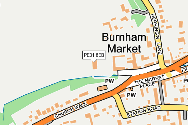
PE31 8EB is located in the Burnham Market & Docking electoral ward, within the local authority district of King's Lynn and West Norfolk and the English Parliamentary constituency of North West Norfolk. The Sub Integrated Care Board (ICB) Location is NHS Norfolk and Waveney ICB - 26A and the police force is Norfolk. This postcode has been in use since January 1980.


GetTheData
Source: OS OpenMap – Local (Ordnance Survey)
Source: OS VectorMap District (Ordnance Survey)
Licence: Open Government Licence (requires attribution)
| Easting | 582997 |
| Northing | 342174 |
| Latitude | 52.945741 |
| Longitude | 0.722146 |
GetTheData
Source: Open Postcode Geo
Licence: Open Government Licence
| Country | England |
| Postcode District | PE31 |
| ➜ PE31 open data dashboard ➜ See where PE31 is on a map ➜ Where is Burnham Market? | |
GetTheData
Source: Land Registry Price Paid Data
Licence: Open Government Licence
Elevation or altitude of PE31 8EB as distance above sea level:
| Metres | Feet | |
|---|---|---|
| Elevation | 10m | 33ft |
Elevation is measured from the approximate centre of the postcode, to the nearest point on an OS contour line from OS Terrain 50, which has contour spacing of ten vertical metres.
➜ How high above sea level am I? Find the elevation of your current position using your device's GPS.
GetTheData
Source: Open Postcode Elevation
Licence: Open Government Licence
| Ward | Burnham Market & Docking |
| Constituency | North West Norfolk |
GetTheData
Source: ONS Postcode Database
Licence: Open Government Licence
| June 2022 | Burglary | On or near Herring'S Lane | 270m |
| June 2022 | Drugs | On or near North Street | 478m |
| May 2022 | Violence and sexual offences | On or near Front Street | 425m |
| ➜ Get more crime data in our Crime section | |||
GetTheData
Source: data.police.uk
Licence: Open Government Licence
| Green (The Green) | Burnham Market | 248m |
| Green (The Green) | Burnham Market | 255m |
| Doctors Surgery (Church Walk) | Burnham Market | 359m |
| Doctors Surgery (Church Walk) | Burnham Market | 394m |
| All Saints Church (North Street) | Burnham Market | 561m |
GetTheData
Source: NaPTAN
Licence: Open Government Licence
GetTheData
Source: ONS Postcode Database
Licence: Open Government Licence


➜ Get more ratings from the Food Standards Agency
GetTheData
Source: Food Standards Agency
Licence: FSA terms & conditions
| Last Collection | |||
|---|---|---|---|
| Location | Mon-Fri | Sat | Distance |
| Church Walk | 16:00 | 10:00 | 393m |
| Church Hill | 15:45 | 08:00 | 1,405m |
| West End | 15:30 | 07:30 | 2,407m |
GetTheData
Source: Dracos
Licence: Creative Commons Attribution-ShareAlike
| Facility | Distance |
|---|---|
| Burnham Market Playing Field Station Road, Burnham Market Grass Pitches, Outdoor Tennis Courts | 491m |
| Burnham Thorpe Playing Field (Closed) Walsingham Road, Burnham Thorpe, King's Lynn Grass Pitches | 2.4km |
| Overy Tennis And Sports Club Gong Lane, Burnham Overy Staithe Outdoor Tennis Courts | 2.4km |
GetTheData
Source: Active Places
Licence: Open Government Licence
| School | Phase of Education | Distance |
|---|---|---|
| Burnham Market Primary School Friars Lane, Burnham Market, King's Lynn, PE31 8JA | Primary | 1km |
GetTheData
Source: Edubase
Licence: Open Government Licence
The below table lists the International Territorial Level (ITL) codes (formerly Nomenclature of Territorial Units for Statistics (NUTS) codes) and Local Administrative Units (LAU) codes for PE31 8EB:
| ITL 1 Code | Name |
|---|---|
| TLH | East |
| ITL 2 Code | Name |
| TLH1 | East Anglia |
| ITL 3 Code | Name |
| TLH16 | North and West Norfolk |
| LAU 1 Code | Name |
| E07000146 | King's Lynn and West Norfolk |
GetTheData
Source: ONS Postcode Directory
Licence: Open Government Licence
The below table lists the Census Output Area (OA), Lower Layer Super Output Area (LSOA), and Middle Layer Super Output Area (MSOA) for PE31 8EB:
| Code | Name | |
|---|---|---|
| OA | E00135405 | |
| LSOA | E01026646 | King's Lynn and West Norfolk 002B |
| MSOA | E02005552 | King's Lynn and West Norfolk 002 |
GetTheData
Source: ONS Postcode Directory
Licence: Open Government Licence
| PE31 8HE | Market Place | 111m |
| PE31 8UL | The Pound | 154m |
| PE31 8HD | Market Place | 220m |
| PE31 8HB | Rogers Row | 233m |
| PE31 8DH | Church Walk | 263m |
| PE31 8HF | Market Place | 278m |
| PE31 8DW | Herrings Lane | 304m |
| PE31 8HA | Station Road | 332m |
| PE31 8EJ | Front Street | 398m |
| PE31 8HG | North Street | 412m |
GetTheData
Source: Open Postcode Geo; Land Registry Price Paid Data
Licence: Open Government Licence