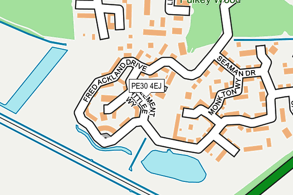
PE30 4EJ lies on Clement Attlee Way in King's Lynn. PE30 4EJ is located in the Fairstead electoral ward, within the local authority district of King's Lynn and West Norfolk and the English Parliamentary constituency of North West Norfolk. The Sub Integrated Care Board (ICB) Location is NHS Norfolk and Waveney ICB - 26A and the police force is Norfolk. This postcode has been in use since July 2011.


GetTheData
Source: OS OpenMap – Local (Ordnance Survey)
Source: OS VectorMap District (Ordnance Survey)
Licence: Open Government Licence (requires attribution)
| Easting | 564291 |
| Northing | 319302 |
| Latitude | 52.746370 |
| Longitude | 0.432517 |
GetTheData
Source: Open Postcode Geo
Licence: Open Government Licence
| Street | Clement Attlee Way |
| Town/City | King's Lynn |
| Country | England |
| Postcode District | PE30 |
➜ See where PE30 is on a map ➜ Where is King's Lynn? | |
GetTheData
Source: Land Registry Price Paid Data
Licence: Open Government Licence
Elevation or altitude of PE30 4EJ as distance above sea level:
| Metres | Feet | |
|---|---|---|
| Elevation | 0m | 0ft |
Elevation is measured from the approximate centre of the postcode, to the nearest point on an OS contour line from OS Terrain 50, which has contour spacing of ten vertical metres.
➜ How high above sea level am I? Find the elevation of your current position using your device's GPS.
GetTheData
Source: Open Postcode Elevation
Licence: Open Government Licence
| Ward | Fairstead |
| Constituency | North West Norfolk |
GetTheData
Source: ONS Postcode Database
Licence: Open Government Licence
| Russell Close (Clement Atlee Way) | Fairstead | 29m |
| Seaman Drive (Fred Ackland Drive) | Fairstead | 179m |
| Beechan Drive (Anthony Nolan Road) | Fairstead | 353m |
| Brockley Green (Winston Churchill Drive) | Fairstead | 380m |
| Fernlea Road (Winston Churchill Drive) | Fairstead | 386m |
| Kings Lynn Station | 2.1km |
GetTheData
Source: NaPTAN
Licence: Open Government Licence
| Percentage of properties with Next Generation Access | 100.0% |
| Percentage of properties with Superfast Broadband | 100.0% |
| Percentage of properties with Ultrafast Broadband | 0.0% |
| Percentage of properties with Full Fibre Broadband | 0.0% |
Superfast Broadband is between 30Mbps and 300Mbps
Ultrafast Broadband is > 300Mbps
| Median download speed | 51.3Mbps |
| Average download speed | 48.7Mbps |
| Maximum download speed | 68.42Mbps |
| Median upload speed | 11.0Mbps |
| Average upload speed | 12.3Mbps |
| Maximum upload speed | 19.53Mbps |
| Percentage of properties unable to receive 2Mbps | 0.0% |
| Percentage of properties unable to receive 5Mbps | 0.0% |
| Percentage of properties unable to receive 10Mbps | 0.0% |
| Percentage of properties unable to receive 30Mbps | 0.0% |
GetTheData
Source: Ofcom
Licence: Ofcom Terms of Use (requires attribution)
Estimated total energy consumption in PE30 4EJ by fuel type, 2015.
| Consumption (kWh) | 248,169 |
|---|---|
| Meter count | 41 |
| Mean (kWh/meter) | 6,053 |
| Median (kWh/meter) | 5,798 |
| Consumption (kWh) | 67,715 |
|---|---|
| Meter count | 41 |
| Mean (kWh/meter) | 1,652 |
| Median (kWh/meter) | 1,364 |
GetTheData
Source: Postcode level gas estimates: 2015 (experimental)
Source: Postcode level electricity estimates: 2015 (experimental)
Licence: Open Government Licence
GetTheData
Source: ONS Postcode Database
Licence: Open Government Licence


➜ Get more ratings from the Food Standards Agency
GetTheData
Source: Food Standards Agency
Licence: FSA terms & conditions
| Last Collection | |||
|---|---|---|---|
| Location | Mon-Fri | Sat | Distance |
| Telford Close | 17:30 | 12:15 | 431m |
| Ploughman Road | 17:30 | 12:15 | 552m |
| Ingleby Close | 17:45 | 12:30 | 612m |
GetTheData
Source: Dracos
Licence: Creative Commons Attribution-ShareAlike
| Risk of PE30 4EJ flooding from rivers and sea | Low |
| ➜ PE30 4EJ flood map | |
GetTheData
Source: Open Flood Risk by Postcode
Licence: Open Government Licence
The below table lists the International Territorial Level (ITL) codes (formerly Nomenclature of Territorial Units for Statistics (NUTS) codes) and Local Administrative Units (LAU) codes for PE30 4EJ:
| ITL 1 Code | Name |
|---|---|
| TLH | East |
| ITL 2 Code | Name |
| TLH1 | East Anglia |
| ITL 3 Code | Name |
| TLH16 | North and West Norfolk |
| LAU 1 Code | Name |
| E07000146 | King's Lynn and West Norfolk |
GetTheData
Source: ONS Postcode Directory
Licence: Open Government Licence
The below table lists the Census Output Area (OA), Lower Layer Super Output Area (LSOA), and Middle Layer Super Output Area (MSOA) for PE30 4EJ:
| Code | Name | |
|---|---|---|
| OA | E00169849 | |
| LSOA | E01026662 | King's Lynn and West Norfolk 010A |
| MSOA | E02005560 | King's Lynn and West Norfolk 010 |
GetTheData
Source: ONS Postcode Directory
Licence: Open Government Licence
| PE30 4GR | Fred Ackland Drive | 44m |
| PE30 4NQ | Russell Close | 77m |
| PE30 4DL | Fred Ackland Drive | 86m |
| PE30 4GT | Mellisham Walk | 102m |
| PE30 4HB | Wilson Crescent | 103m |
| PE30 4GJ | Anthony Nolan Road | 156m |
| PE30 4SH | Kings Green | 163m |
| PE30 4GS | Monkton Way | 164m |
| PE30 4SG | Silver Green | 190m |
| PE30 4GP | Seaman Drive | 196m |
GetTheData
Source: Open Postcode Geo; Land Registry Price Paid Data
Licence: Open Government Licence