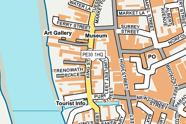
PE30 1HQ is located in the St. Margaret's with St. Nicholas electoral ward, within the local authority district of King's Lynn and West Norfolk and the English Parliamentary constituency of North West Norfolk. The Sub Integrated Care Board (ICB) Location is NHS Norfolk and Waveney ICB - 26A and the police force is Norfolk. This postcode has been in use since January 1980.


GetTheData
Source: OS OpenMap – Local (Ordnance Survey)
Source: OS VectorMap District (Ordnance Survey)
Licence: Open Government Licence (requires attribution)
| Easting | 561651 |
| Northing | 320157 |
| Latitude | 52.754845 |
| Longitude | 0.393864 |
GetTheData
Source: Open Postcode Geo
Licence: Open Government Licence
| Country | England |
| Postcode District | PE30 |
| ➜ PE30 open data dashboard ➜ See where PE30 is on a map ➜ Where is King's Lynn? | |
GetTheData
Source: Land Registry Price Paid Data
Licence: Open Government Licence
Elevation or altitude of PE30 1HQ as distance above sea level:
| Metres | Feet | |
|---|---|---|
| Elevation | 0m | 0ft |
Elevation is measured from the approximate centre of the postcode, to the nearest point on an OS contour line from OS Terrain 50, which has contour spacing of ten vertical metres.
➜ How high above sea level am I? Find the elevation of your current position using your device's GPS.
GetTheData
Source: Open Postcode Elevation
Licence: Open Government Licence
| Ward | St. Margaret's With St. Nicholas |
| Constituency | North West Norfolk |
GetTheData
Source: ONS Postcode Database
Licence: Open Government Licence
| January 2024 | Criminal damage and arson | On or near Parking Area | 228m |
| January 2024 | Public order | On or near Parking Area | 228m |
| January 2024 | Shoplifting | On or near Parking Area | 385m |
| ➜ Get more crime data in our Crime section | |||
GetTheData
Source: data.police.uk
Licence: Open Government Licence
| Austin Fields (John Kennedy Road) | King's Lynn | 424m |
| Austin Fields (John Kennedy Road) | King's Lynn | 443m |
| Kempe Road (St Peters Road) | West Lynn | 474m |
| Kempe Road (St Peters Road) | West Lynn | 482m |
| Hillington Square (Stonegate) | King's Lynn | 545m |
| Kings Lynn Station | 0.7km |
GetTheData
Source: NaPTAN
Licence: Open Government Licence
GetTheData
Source: ONS Postcode Database
Licence: Open Government Licence


➜ Get more ratings from the Food Standards Agency
GetTheData
Source: Food Standards Agency
Licence: FSA terms & conditions
| Last Collection | |||
|---|---|---|---|
| Location | Mon-Fri | Sat | Distance |
| Bridge Street | 17:45 | 12:15 | 127m |
| Tuesday Market Place | 18:30 | 12:15 | 137m |
| Kings Lynn Bo | 18:30 | 12:45 | 148m |
GetTheData
Source: Dracos
Licence: Creative Commons Attribution-ShareAlike
| Facility | Distance |
|---|---|
| Tower Health & Beauty Clinic (Closed) Tower Place, King's Lynn Health and Fitness Gym | 467m |
| St James Swimming And Fitness Centre Blackfriars Street, King's Lynn Swimming Pool, Health and Fitness Gym | 487m |
| West Lynn St. Peters Road, West Lynn, King's Lynn Grass Pitches | 629m |
GetTheData
Source: Active Places
Licence: Open Government Licence
| School | Phase of Education | Distance |
|---|---|---|
| Visiting Teacher Service West Gaywood, King's Lynn, PE30 5DR | Not applicable | 404m |
| West Lynn Primary School St Peter's Road, West Lynn, King's Lynn, PE34 3JL | Primary | 528m |
| King's Lynn Nursery School St James Park, London Road, King's Lynn, PE30 5PT | Nursery | 581m |
GetTheData
Source: Edubase
Licence: Open Government Licence
The below table lists the International Territorial Level (ITL) codes (formerly Nomenclature of Territorial Units for Statistics (NUTS) codes) and Local Administrative Units (LAU) codes for PE30 1HQ:
| ITL 1 Code | Name |
|---|---|
| TLH | East |
| ITL 2 Code | Name |
| TLH1 | East Anglia |
| ITL 3 Code | Name |
| TLH16 | North and West Norfolk |
| LAU 1 Code | Name |
| E07000146 | King's Lynn and West Norfolk |
GetTheData
Source: ONS Postcode Directory
Licence: Open Government Licence
The below table lists the Census Output Area (OA), Lower Layer Super Output Area (LSOA), and Middle Layer Super Output Area (MSOA) for PE30 1HQ:
| Code | Name | |
|---|---|---|
| OA | E00135698 | |
| LSOA | E01026698 | King's Lynn and West Norfolk 011A |
| MSOA | E02005561 | King's Lynn and West Norfolk 011 |
GetTheData
Source: ONS Postcode Directory
Licence: Open Government Licence
| PE30 1HJ | King Street | 8m |
| PE30 1ES | King Street | 25m |
| PE30 1ET | King Street | 53m |
| PE30 1HW | Aickmans Yard | 60m |
| PE30 1DB | Old School Court | 74m |
| PE30 1BB | High Street | 81m |
| PE30 1HN | Ferry Lane | 91m |
| PE30 1EN | Trenowath Place | 93m |
| PE30 1BE | High Street | 98m |
| PE30 1JJ | Tuesday Market Place | 102m |
GetTheData
Source: Open Postcode Geo; Land Registry Price Paid Data
Licence: Open Government Licence