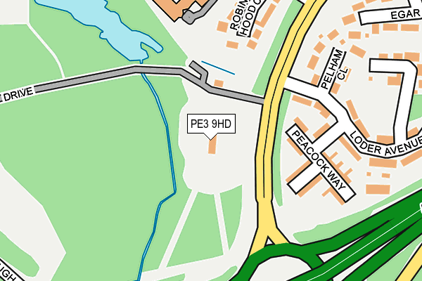
PE3 9HD is located in the West electoral ward, within the unitary authority of Peterborough and the English Parliamentary constituency of Peterborough. The Sub Integrated Care Board (ICB) Location is NHS Cambridgeshire and Peterborough ICB - 06H and the police force is Cambridgeshire. This postcode has been in use since May 2005.


GetTheData
Source: OS OpenMap – Local (Ordnance Survey)
Source: OS VectorMap District (Ordnance Survey)
Licence: Open Government Licence (requires attribution)
| Easting | 515504 |
| Northing | 298768 |
| Latitude | 52.574475 |
| Longitude | -0.297022 |
GetTheData
Source: Open Postcode Geo
Licence: Open Government Licence
| Country | England |
| Postcode District | PE3 |
| ➜ PE3 open data dashboard ➜ See where PE3 is on a map ➜ Where is Peterborough? | |
GetTheData
Source: Land Registry Price Paid Data
Licence: Open Government Licence
Elevation or altitude of PE3 9HD as distance above sea level:
| Metres | Feet | |
|---|---|---|
| Elevation | 20m | 66ft |
Elevation is measured from the approximate centre of the postcode, to the nearest point on an OS contour line from OS Terrain 50, which has contour spacing of ten vertical metres.
➜ How high above sea level am I? Find the elevation of your current position using your device's GPS.
GetTheData
Source: Open Postcode Elevation
Licence: Open Government Licence
| Ward | West |
| Constituency | Peterborough |
GetTheData
Source: ONS Postcode Database
Licence: Open Government Licence
| December 2023 | Anti-social behaviour | On or near Little Johns Close | 337m |
| July 2023 | Vehicle crime | On or near Little Johns Close | 337m |
| April 2023 | Other theft | On or near Little Johns Close | 337m |
| ➜ Get more crime data in our Crime section | |||
GetTheData
Source: data.police.uk
Licence: Open Government Licence
| Fitzwilliam Hosp (Bretton Way) | South Bretton | 107m |
| Fitzwilliam Hosp (Bretton Way) | South Bretton | 133m |
| Police Headquarters (Thorpe Wood Road) | Thorpe Wood | 358m |
| Police Headquarters (Thorpe Wood Road) | Thorpe Wood | 366m |
| Copeland (Bretton Way) | South Bretton | 499m |
| Peterborough Station | 3.2km |
GetTheData
Source: NaPTAN
Licence: Open Government Licence
GetTheData
Source: ONS Postcode Database
Licence: Open Government Licence


➜ Get more ratings from the Food Standards Agency
GetTheData
Source: Food Standards Agency
Licence: FSA terms & conditions
| Last Collection | |||
|---|---|---|---|
| Location | Mon-Fri | Sat | Distance |
| Bretton South Post Office | 18:00 | 11:45 | 464m |
| Manton-bretton Way | 18:00 | 12:45 | 565m |
| Grove Lane | 18:15 | 13:00 | 643m |
GetTheData
Source: Dracos
Licence: Creative Commons Attribution-ShareAlike
| Facility | Distance |
|---|---|
| David Lloyd (Peterborough) Thorpe Wood, Peterborough Swimming Pool, Health and Fitness Gym, Indoor Tennis Centre, Sports Hall, Studio, Outdoor Tennis Courts | 491m |
| Thomas Cook (Closed) Thorpe Wood Road, Peterborough Grass Pitches | 675m |
| South Bretton Playing Field Ringwood, Bretton, Peterborough Grass Pitches | 749m |
GetTheData
Source: Active Places
Licence: Open Government Licence
| School | Phase of Education | Distance |
|---|---|---|
| Longthorpe Primary School Bradwell Road, Longthorpe, Peterborough, PE3 9QW | Primary | 974m |
| Nova Primary Academy South Bretton, Peterborough, PE3 9XJ | Primary | 1.2km |
| Jack Hunt School Bradwell Road, Peterborough, PE3 9PY | Secondary | 1.5km |
GetTheData
Source: Edubase
Licence: Open Government Licence
The below table lists the International Territorial Level (ITL) codes (formerly Nomenclature of Territorial Units for Statistics (NUTS) codes) and Local Administrative Units (LAU) codes for PE3 9HD:
| ITL 1 Code | Name |
|---|---|
| TLH | East |
| ITL 2 Code | Name |
| TLH1 | East Anglia |
| ITL 3 Code | Name |
| TLH11 | Peterborough |
| LAU 1 Code | Name |
| E06000031 | Peterborough |
GetTheData
Source: ONS Postcode Directory
Licence: Open Government Licence
The below table lists the Census Output Area (OA), Lower Layer Super Output Area (LSOA), and Middle Layer Super Output Area (MSOA) for PE3 9HD:
| Code | Name | |
|---|---|---|
| OA | E00078880 | |
| LSOA | E01015598 | Peterborough 015A |
| MSOA | E02003251 | Peterborough 015 |
GetTheData
Source: ONS Postcode Directory
Licence: Open Government Licence
| PE3 9AA | Peacock Way | 171m |
| PE3 9AR | Robin Hood Close | 186m |
| PE3 9AD | Pelham Close | 186m |
| PE3 9AB | Loder Avenue | 241m |
| PE3 9TL | Longthorpe House Mews | 274m |
| PE3 9AP | Milton Way | 316m |
| PE3 9AE | Egar Way | 323m |
| PE3 9AS | Little Johns Close | 343m |
| PE3 9AF | Harrison Close | 389m |
| PE3 9BT | Sebrights Way | 419m |
GetTheData
Source: Open Postcode Geo; Land Registry Price Paid Data
Licence: Open Government Licence