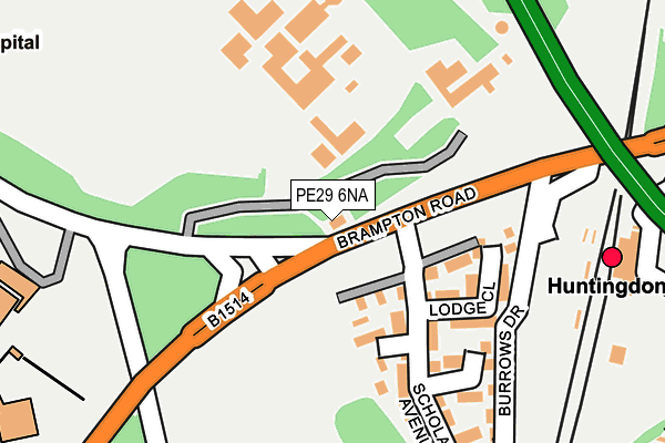
PE29 6NA lies on Brampton Road in Huntingdon. PE29 6NA is located in the Brampton electoral ward, within the local authority district of Huntingdonshire and the English Parliamentary constituency of Huntingdon. The Sub Integrated Care Board (ICB) Location is NHS Cambridgeshire and Peterborough ICB - 06H and the police force is Cambridgeshire. This postcode has been in use since June 2000.


GetTheData
Source: OS OpenMap – Local (Ordnance Survey)
Source: OS VectorMap District (Ordnance Survey)
Licence: Open Government Licence (requires attribution)
| Easting | 523178 |
| Northing | 271831 |
| Latitude | 52.330765 |
| Longitude | -0.193752 |
GetTheData
Source: Open Postcode Geo
Licence: Open Government Licence
| Street | Brampton Road |
| Town/City | Huntingdon |
| Country | England |
| Postcode District | PE29 |
| ➜ PE29 open data dashboard ➜ See where PE29 is on a map ➜ Where is Huntingdon? | |
GetTheData
Source: Land Registry Price Paid Data
Licence: Open Government Licence
Elevation or altitude of PE29 6NA as distance above sea level:
| Metres | Feet | |
|---|---|---|
| Elevation | 20m | 66ft |
Elevation is measured from the approximate centre of the postcode, to the nearest point on an OS contour line from OS Terrain 50, which has contour spacing of ten vertical metres.
➜ How high above sea level am I? Find the elevation of your current position using your device's GPS.
GetTheData
Source: Open Postcode Elevation
Licence: Open Government Licence
| Ward | Brampton |
| Constituency | Huntingdon |
GetTheData
Source: ONS Postcode Database
Licence: Open Government Licence
2022 23 SEP £325,000 |
2019 3 SEP £265,000 |
2005 15 JUL £230,000 |
2003 16 MAY £170,000 |
1998 7 AUG £60,000 |
GetTheData
Source: HM Land Registry Price Paid Data
Licence: Contains HM Land Registry data © Crown copyright and database right 2024. This data is licensed under the Open Government Licence v3.0.
| January 2024 | Other crime | On or near Parking Area | 189m |
| January 2024 | Other crime | On or near Lodge Close | 227m |
| January 2024 | Anti-social behaviour | On or near Lodge Close | 227m |
| ➜ Get more crime data in our Crime section | |||
GetTheData
Source: data.police.uk
Licence: Open Government Licence
| Railway Station (Brampton Road) | Huntingdon | 164m |
| Railway Station | Huntingdon | 203m |
| Playing Field (Brampton Road) | Hinchingbrooke Park | 261m |
| Millfield Park (Brampton Road) | Huntingdon | 273m |
| Millfield Park (Brampton Road) | Huntingdon | 296m |
| Huntingdon Station | 0.3km |
GetTheData
Source: NaPTAN
Licence: Open Government Licence
GetTheData
Source: ONS Postcode Database
Licence: Open Government Licence


➜ Get more ratings from the Food Standards Agency
GetTheData
Source: Food Standards Agency
Licence: FSA terms & conditions
| Last Collection | |||
|---|---|---|---|
| Location | Mon-Fri | Sat | Distance |
| Station | 17:30 | 12:00 | 244m |
| North End-ermine Street | 17:45 | 12:30 | 513m |
| Market Square | 18:00 | 12:00 | 664m |
GetTheData
Source: Dracos
Licence: Creative Commons Attribution-ShareAlike
| Facility | Distance |
|---|---|
| Hinchingbrooke School Brampton Road, Huntingdon Health and Fitness Gym, Grass Pitches, Artificial Grass Pitch, Sports Hall, Swimming Pool, Studio, Outdoor Tennis Courts | 608m |
| Anytime Fitness (Huntingdon) High Street, High Street, Huntingdon Health and Fitness Gym | 757m |
| Huntingdon Indoor Bowls Club St. Peters Road, Huntingdon Indoor Bowls | 826m |
GetTheData
Source: Active Places
Licence: Open Government Licence
| School | Phase of Education | Distance |
|---|---|---|
| Hinchingbrooke School Brampton Road, Huntingdon, PE29 3BN | Secondary | 575m |
| Stukeley Meadows Primary School Wertheim Way, Huntingdon, PE29 6UH | Primary | 783m |
| Cromwell Academy Parkway, Hinchingbrooke Park, Huntingdon, PE29 6JA | Primary | 937m |
GetTheData
Source: Edubase
Licence: Open Government Licence
The below table lists the International Territorial Level (ITL) codes (formerly Nomenclature of Territorial Units for Statistics (NUTS) codes) and Local Administrative Units (LAU) codes for PE29 6NA:
| ITL 1 Code | Name |
|---|---|
| TLH | East |
| ITL 2 Code | Name |
| TLH1 | East Anglia |
| ITL 3 Code | Name |
| TLH12 | Cambridgeshire CC |
| LAU 1 Code | Name |
| E07000011 | Huntingdonshire |
GetTheData
Source: ONS Postcode Directory
Licence: Open Government Licence
The below table lists the Census Output Area (OA), Lower Layer Super Output Area (LSOA), and Middle Layer Super Output Area (MSOA) for PE29 6NA:
| Code | Name | |
|---|---|---|
| OA | E00173808 | |
| LSOA | E01018151 | Huntingdonshire 012E |
| MSOA | E02003764 | Huntingdonshire 012 |
GetTheData
Source: ONS Postcode Directory
Licence: Open Government Licence
| PE29 3BH | Brampton Road | 236m |
| PE29 6GR | Lodge Close | 239m |
| PE29 3BQ | Brampton Road | 273m |
| PE29 6GS | Headlands | 300m |
| PE29 3BX | Roscrea Court | 302m |
| PE29 3TR | Millfield Park | 302m |
| PE29 3TS | Millfield Park | 323m |
| PE29 3TT | Brampton Road | 329m |
| PE29 6GP | Scholars Avenue | 333m |
| PE29 3DE | Roscrea Terrace | 338m |
GetTheData
Source: Open Postcode Geo; Land Registry Price Paid Data
Licence: Open Government Licence