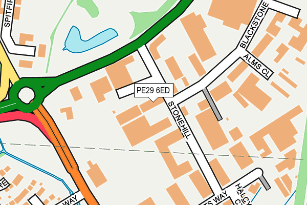
PE29 6ED lies on Stonehill in Stukeley Meadows Industrial Estate, Huntingdon. PE29 6ED is located in the Huntingdon North electoral ward, within the local authority district of Huntingdonshire and the English Parliamentary constituency of Huntingdon. The Sub Integrated Care Board (ICB) Location is NHS Cambridgeshire and Peterborough ICB - 06H and the police force is Cambridgeshire. This postcode has been in use since June 2000.


GetTheData
Source: OS OpenMap – Local (Ordnance Survey)
Source: OS VectorMap District (Ordnance Survey)
Licence: Open Government Licence (requires attribution)
| Easting | 523164 |
| Northing | 273189 |
| Latitude | 52.342956 |
| Longitude | -0.193481 |
GetTheData
Source: Open Postcode Geo
Licence: Open Government Licence
| Street | Stonehill |
| Locality | Stukeley Meadows Industrial Estate |
| Town/City | Huntingdon |
| Country | England |
| Postcode District | PE29 |
| ➜ PE29 open data dashboard ➜ See where PE29 is on a map ➜ Where is Huntingdon? | |
GetTheData
Source: Land Registry Price Paid Data
Licence: Open Government Licence
Elevation or altitude of PE29 6ED as distance above sea level:
| Metres | Feet | |
|---|---|---|
| Elevation | 20m | 66ft |
Elevation is measured from the approximate centre of the postcode, to the nearest point on an OS contour line from OS Terrain 50, which has contour spacing of ten vertical metres.
➜ How high above sea level am I? Find the elevation of your current position using your device's GPS.
GetTheData
Source: Open Postcode Elevation
Licence: Open Government Licence
| Ward | Huntingdon North |
| Constituency | Huntingdon |
GetTheData
Source: ONS Postcode Database
Licence: Open Government Licence
| September 2023 | Public order | On or near Lakeview Court | 338m |
| August 2023 | Other theft | On or near Lakeview Court | 338m |
| June 2023 | Other theft | On or near Lakeview Court | 338m |
| ➜ Stonehill crime map and outcomes | |||
GetTheData
Source: data.police.uk
Licence: Open Government Licence
| Blackstone Road (Stonehill) | Huntingdon | 27m |
| Blackstone Road (Stonehill) | Huntingdon | 35m |
| St Margarets Way (Stukeley Road) | Huntingdon | 275m |
| St Margarets Way (Stukeley Road) | Huntingdon | 283m |
| Ermine Business Park (Ermine Street) | Great Stukeley | 420m |
| Huntingdon Station | 1.6km |
GetTheData
Source: NaPTAN
Licence: Open Government Licence
| Median download speed | 78.9Mbps |
| Average download speed | 61.7Mbps |
| Maximum download speed | 80.00Mbps |
| Median upload speed | 20.0Mbps |
| Average upload speed | 15.3Mbps |
| Maximum upload speed | 20.00Mbps |
GetTheData
Source: Ofcom
Licence: Ofcom Terms of Use (requires attribution)
Estimated total energy consumption in PE29 6ED by fuel type, 2015.
| Consumption (kWh) | 111,390 |
|---|---|
| Meter count | 7 |
| Mean (kWh/meter) | 15,913 |
| Median (kWh/meter) | 9,688 |
GetTheData
Source: Postcode level gas estimates: 2015 (experimental)
Source: Postcode level electricity estimates: 2015 (experimental)
Licence: Open Government Licence
GetTheData
Source: ONS Postcode Database
Licence: Open Government Licence


➜ Get more ratings from the Food Standards Agency
GetTheData
Source: Food Standards Agency
Licence: FSA terms & conditions
| Last Collection | |||
|---|---|---|---|
| Location | Mon-Fri | Sat | Distance |
| Ermine Business Park | 18:00 | 484m | |
| Ermine Business Park | 18:00 | 11:30 | 487m |
| Stukeley Road | 17:30 | 11:30 | 542m |
GetTheData
Source: Dracos
Licence: Creative Commons Attribution-ShareAlike
| Facility | Distance |
|---|---|
| King George V Playing Fields (St Peters Road) St Peters Road, Huntingdon Grass Pitches | 671m |
| St Peters School St. Peters Road, Huntingdon Sports Hall, Grass Pitches, Studio | 687m |
| Huntingdon Indoor Bowls Club St. Peters Road, Huntingdon Indoor Bowls | 748m |
GetTheData
Source: Active Places
Licence: Open Government Licence
| School | Phase of Education | Distance |
|---|---|---|
| Stukeley Meadows Primary School Wertheim Way, Huntingdon, PE29 6UH | Primary | 578m |
| St Peter's School St Peter's Road, Huntingdon, PE29 7DD | Secondary | 686m |
| St John's CofE Primary School Sallowbush Road, Huntingdon, PE29 7LA | Primary | 1km |
GetTheData
Source: Edubase
Licence: Open Government Licence
The below table lists the International Territorial Level (ITL) codes (formerly Nomenclature of Territorial Units for Statistics (NUTS) codes) and Local Administrative Units (LAU) codes for PE29 6ED:
| ITL 1 Code | Name |
|---|---|
| TLH | East |
| ITL 2 Code | Name |
| TLH1 | East Anglia |
| ITL 3 Code | Name |
| TLH12 | Cambridgeshire CC |
| LAU 1 Code | Name |
| E07000011 | Huntingdonshire |
GetTheData
Source: ONS Postcode Directory
Licence: Open Government Licence
The below table lists the Census Output Area (OA), Lower Layer Super Output Area (LSOA), and Middle Layer Super Output Area (MSOA) for PE29 6ED:
| Code | Name | |
|---|---|---|
| OA | E00091571 | |
| LSOA | E01018150 | Huntingdonshire 012D |
| MSOA | E02003764 | Huntingdonshire 012 |
GetTheData
Source: ONS Postcode Directory
Licence: Open Government Licence
| PE29 6EF | Blackstone Road | 241m |
| PE29 6DG | Halcyon Court | 272m |
| PE29 6UD | Coniston Close | 304m |
| PE29 6UA | Lakeview Court | 314m |
| PE29 6EH | Blackstone Road | 317m |
| PE29 6UF | Rydal Close | 328m |
| PE29 6XY | Spitfire Close | 338m |
| PE29 6UB | Buttermere | 358m |
| PE29 6HH | Stukeley Road | 385m |
| PE29 6WN | Knipe Close | 420m |
GetTheData
Source: Open Postcode Geo; Land Registry Price Paid Data
Licence: Open Government Licence