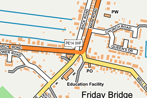
PE14 0HF lies on March Road in Friday Bridge, Wisbech. PE14 0HF is located in the Elm & Christchurch electoral ward, within the local authority district of Fenland and the English Parliamentary constituency of North East Cambridgeshire. The Sub Integrated Care Board (ICB) Location is NHS Cambridgeshire and Peterborough ICB - 06H and the police force is Cambridgeshire. This postcode has been in use since January 1980.


GetTheData
Source: OS OpenMap – Local (Ordnance Survey)
Source: OS VectorMap District (Ordnance Survey)
Licence: Open Government Licence (requires attribution)
| Easting | 546540 |
| Northing | 304754 |
| Latitude | 52.620782 |
| Longitude | 0.163286 |
GetTheData
Source: Open Postcode Geo
Licence: Open Government Licence
| Street | March Road |
| Locality | Friday Bridge |
| Town/City | Wisbech |
| Country | England |
| Postcode District | PE14 |
| ➜ PE14 open data dashboard ➜ See where PE14 is on a map ➜ Where is Friday Bridge? | |
GetTheData
Source: Land Registry Price Paid Data
Licence: Open Government Licence
Elevation or altitude of PE14 0HF as distance above sea level:
| Metres | Feet | |
|---|---|---|
| Elevation | 0m | 0ft |
Elevation is measured from the approximate centre of the postcode, to the nearest point on an OS contour line from OS Terrain 50, which has contour spacing of ten vertical metres.
➜ How high above sea level am I? Find the elevation of your current position using your device's GPS.
GetTheData
Source: Open Postcode Elevation
Licence: Open Government Licence
| Ward | Elm & Christchurch |
| Constituency | North East Cambridgeshire |
GetTheData
Source: ONS Postcode Database
Licence: Open Government Licence
LITTLE BRETTON, MARCH ROAD, FRIDAY BRIDGE, WISBECH, PE14 0HF 1998 9 APR £52,000 |
LITTLE BRETTON, MARCH ROAD, FRIDAY BRIDGE, WISBECH, PE14 0HF 1995 26 MAY £49,000 |
GetTheData
Source: HM Land Registry Price Paid Data
Licence: Contains HM Land Registry data © Crown copyright and database right 2024. This data is licensed under the Open Government Licence v3.0.
| January 2024 | Anti-social behaviour | On or near Tower Road | 268m |
| July 2023 | Vehicle crime | On or near Tower Road | 268m |
| May 2022 | Violence and sexual offences | On or near Queen'S Drive | 213m |
| ➜ Get more crime data in our Crime section | |||
GetTheData
Source: data.police.uk
Licence: Open Government Licence
| Well End (Main Road) | Friday Bridge | 33m |
| Well End (Main Road) | Friday Bridge | 50m |
| March Road | Friday Bridge | 177m |
| March Road | Friday Bridge | 177m |
| The Stitch (Main Road) | Friday Bridge | 529m |
GetTheData
Source: NaPTAN
Licence: Open Government Licence
GetTheData
Source: ONS Postcode Database
Licence: Open Government Licence


➜ Get more ratings from the Food Standards Agency
GetTheData
Source: Food Standards Agency
Licence: FSA terms & conditions
| Last Collection | |||
|---|---|---|---|
| Location | Mon-Fri | Sat | Distance |
| Birch Grove Elm | 16:45 | 07:45 | 1,773m |
| Elm Church Elm | 17:15 | 08:30 | 2,154m |
| Elm Post Office | 17:20 | 09:20 | 2,763m |
GetTheData
Source: Dracos
Licence: Creative Commons Attribution-ShareAlike
| Facility | Distance |
|---|---|
| Begdale Road Playing Field Begdale Road, Elm Grass Pitches | 2km |
| Lakers Gymnasium Anglia Way, Wisbech Health and Fitness Gym | 3.4km |
| Esselle Ladies Health And Leisure Ltd (Closed) Algores Way, Wisbech Health and Fitness Gym, Studio | 3.6km |
GetTheData
Source: Active Places
Licence: Open Government Licence
| School | Phase of Education | Distance |
|---|---|---|
| The Old School House 1 March Road, Friday Bridge, Wisbech, PE14 0HA | Not applicable | 30m |
| Friday Bridge Community Primary School Maltmas Drove, Friday Bridge, Wisbech, PE14 0HW | Primary | 97m |
| Shelldene House School Shelldene House, 20 Main Road, Friday Bridge, Wisbech, PE14 0HJ | Not applicable | 240m |
GetTheData
Source: Edubase
Licence: Open Government Licence
The below table lists the International Territorial Level (ITL) codes (formerly Nomenclature of Territorial Units for Statistics (NUTS) codes) and Local Administrative Units (LAU) codes for PE14 0HF:
| ITL 1 Code | Name |
|---|---|
| TLH | East |
| ITL 2 Code | Name |
| TLH1 | East Anglia |
| ITL 3 Code | Name |
| TLH12 | Cambridgeshire CC |
| LAU 1 Code | Name |
| E07000010 | Fenland |
GetTheData
Source: ONS Postcode Directory
Licence: Open Government Licence
The below table lists the Census Output Area (OA), Lower Layer Super Output Area (LSOA), and Middle Layer Super Output Area (MSOA) for PE14 0HF:
| Code | Name | |
|---|---|---|
| OA | E00091145 | |
| LSOA | E01018066 | Fenland 004A |
| MSOA | E02003745 | Fenland 004 |
GetTheData
Source: ONS Postcode Directory
Licence: Open Government Licence
| PE14 0HG | Well End | 169m |
| PE14 0HU | Back Road | 175m |
| PE14 0HJ | Main Road | 184m |
| PE14 0JB | Queens Drive | 199m |
| PE14 0HN | Church Road | 207m |
| PE14 0HP | Tower Road | 257m |
| PE14 0HT | Kilderkin Close | 285m |
| PE14 0HA | March Road | 302m |
| PE14 0LT | Grace Court | 315m |
| PE14 0JD | West Drive | 378m |
GetTheData
Source: Open Postcode Geo; Land Registry Price Paid Data
Licence: Open Government Licence