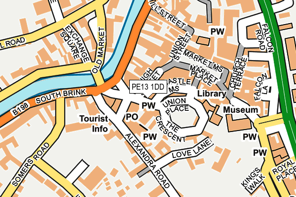
PE13 1DD is located in the Wisbech South electoral ward, within the local authority district of Fenland and the English Parliamentary constituency of North East Cambridgeshire. The Sub Integrated Care Board (ICB) Location is NHS Cambridgeshire and Peterborough ICB - 06H and the police force is Cambridgeshire. This postcode has been in use since January 1980.


GetTheData
Source: OS OpenMap – Local (Ordnance Survey)
Source: OS VectorMap District (Ordnance Survey)
Licence: Open Government Licence (requires attribution)
| Easting | 546123 |
| Northing | 309609 |
| Latitude | 52.664508 |
| Longitude | 0.159278 |
GetTheData
Source: Open Postcode Geo
Licence: Open Government Licence
| Country | England |
| Postcode District | PE13 |
| ➜ PE13 open data dashboard ➜ See where PE13 is on a map ➜ Where is Wisbech? | |
GetTheData
Source: Land Registry Price Paid Data
Licence: Open Government Licence
Elevation or altitude of PE13 1DD as distance above sea level:
| Metres | Feet | |
|---|---|---|
| Elevation | 0m | 0ft |
Elevation is measured from the approximate centre of the postcode, to the nearest point on an OS contour line from OS Terrain 50, which has contour spacing of ten vertical metres.
➜ How high above sea level am I? Find the elevation of your current position using your device's GPS.
GetTheData
Source: Open Postcode Elevation
Licence: Open Government Licence
| Ward | Wisbech South |
| Constituency | North East Cambridgeshire |
GetTheData
Source: ONS Postcode Database
Licence: Open Government Licence
| January 2024 | Violence and sexual offences | On or near Parking Area | 245m |
| January 2024 | Anti-social behaviour | On or near Parking Area | 322m |
| January 2024 | Anti-social behaviour | On or near Parking Area | 322m |
| ➜ Get more crime data in our Crime section | |||
GetTheData
Source: data.police.uk
Licence: Open Government Licence
| North Street | Wisbech | 242m |
| North End | Wisbech | 324m |
| Grammar School (Harecroft Road) | Wisbech | 444m |
| Grammar School (Harecroft Road) | Wisbech | 445m |
| North End | Wisbech | 475m |
GetTheData
Source: NaPTAN
Licence: Open Government Licence
GetTheData
Source: ONS Postcode Database
Licence: Open Government Licence


➜ Get more ratings from the Food Standards Agency
GetTheData
Source: Food Standards Agency
Licence: FSA terms & conditions
| Last Collection | |||
|---|---|---|---|
| Location | Mon-Fri | Sat | Distance |
| Bridge Street Post Office | 18:30 | 12:30 | 52m |
| Old Market | 18:30 | 11:45 | 217m |
| North Brink | 16:45 | 08:00 | 479m |
GetTheData
Source: Dracos
Licence: Creative Commons Attribution-ShareAlike
| Facility | Distance |
|---|---|
| Shapers Gym North Street, Wisbech Health and Fitness Gym | 285m |
| Wisbech Rugby Club Chapel Road, Wisbech Grass Pitches | 298m |
| Wisbech Grammar School North Brink, Wisbech Sports Hall, Grass Pitches, Artificial Grass Pitch, Outdoor Tennis Courts | 502m |
GetTheData
Source: Active Places
Licence: Open Government Licence
| School | Phase of Education | Distance |
|---|---|---|
| Cambian Wisbech School Old Sessions House, 32 Somers Road, Wisbech, PE13 1JF | Not applicable | 238m |
| Olive AP Academy - Nene Valley Coalwharf Road, Wisbech, PE13 2FP | Not applicable | 361m |
| The Nene Infant & Nursery School Norwich Road, Wisbech, PE13 2AP | Primary | 483m |
GetTheData
Source: Edubase
Licence: Open Government Licence
The below table lists the International Territorial Level (ITL) codes (formerly Nomenclature of Territorial Units for Statistics (NUTS) codes) and Local Administrative Units (LAU) codes for PE13 1DD:
| ITL 1 Code | Name |
|---|---|
| TLH | East |
| ITL 2 Code | Name |
| TLH1 | East Anglia |
| ITL 3 Code | Name |
| TLH12 | Cambridgeshire CC |
| LAU 1 Code | Name |
| E07000010 | Fenland |
GetTheData
Source: ONS Postcode Directory
Licence: Open Government Licence
The below table lists the Census Output Area (OA), Lower Layer Super Output Area (LSOA), and Middle Layer Super Output Area (MSOA) for PE13 1DD:
| Code | Name | |
|---|---|---|
| OA | E00091269 | |
| LSOA | E01033112 | Fenland 003I |
| MSOA | E02003744 | Fenland 003 |
GetTheData
Source: ONS Postcode Directory
Licence: Open Government Licence
| PE13 1EB | York Row | 26m |
| PE13 1EA | York Row | 31m |
| PE13 1DB | High Street | 39m |
| PE13 1SP | Crescent Passage | 40m |
| PE13 1HG | Post Office Lane | 44m |
| PE13 1HD | Castle Mews | 46m |
| PE13 1DE | High Street | 47m |
| PE13 1HB | Union Place | 52m |
| PE13 1AF | Bridge Street | 75m |
| PE13 1DG | Market Place | 87m |
GetTheData
Source: Open Postcode Geo; Land Registry Price Paid Data
Licence: Open Government Licence