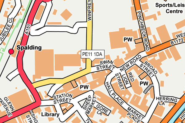
PE11 1DA lies on Winfrey Avenue in Spalding. PE11 1DA is located in the Spalding Castle electoral ward, within the local authority district of South Holland and the English Parliamentary constituency of South Holland and The Deepings. The Sub Integrated Care Board (ICB) Location is NHS Lincolnshire ICB - 71E and the police force is Lincolnshire. This postcode has been in use since January 1980.


GetTheData
Source: OS OpenMap – Local (Ordnance Survey)
Source: OS VectorMap District (Ordnance Survey)
Licence: Open Government Licence (requires attribution)
| Easting | 524702 |
| Northing | 322895 |
| Latitude | 52.789248 |
| Longitude | -0.152228 |
GetTheData
Source: Open Postcode Geo
Licence: Open Government Licence
| Street | Winfrey Avenue |
| Town/City | Spalding |
| Country | England |
| Postcode District | PE11 |
| ➜ PE11 open data dashboard ➜ See where PE11 is on a map ➜ Where is Spalding? | |
GetTheData
Source: Land Registry Price Paid Data
Licence: Open Government Licence
Elevation or altitude of PE11 1DA as distance above sea level:
| Metres | Feet | |
|---|---|---|
| Elevation | 10m | 33ft |
Elevation is measured from the approximate centre of the postcode, to the nearest point on an OS contour line from OS Terrain 50, which has contour spacing of ten vertical metres.
➜ How high above sea level am I? Find the elevation of your current position using your device's GPS.
GetTheData
Source: Open Postcode Elevation
Licence: Open Government Licence
| Ward | Spalding Castle |
| Constituency | South Holland And The Deepings |
GetTheData
Source: ONS Postcode Database
Licence: Open Government Licence
| January 2024 | Violence and sexual offences | On or near Jubilee Close | 337m |
| January 2024 | Violence and sexual offences | On or near Jubilee Close | 337m |
| January 2024 | Criminal damage and arson | On or near Supermarket | 440m |
| ➜ Get more crime data in our Crime section | |||
GetTheData
Source: data.police.uk
Licence: Open Government Licence
| Broad Street (New Road) | Spalding | 101m |
| Broad Street (New Road) | Spalding | 123m |
| Bus Station (Winfrey Avenue) | Spalding | 135m |
| Kings Road (Pinchbeck Road) | Spalding | 189m |
| Kings Road (Pinchbeck Road) | Spalding | 234m |
| Spalding Station | 0.3km |
GetTheData
Source: NaPTAN
Licence: Open Government Licence
GetTheData
Source: ONS Postcode Database
Licence: Open Government Licence


➜ Get more ratings from the Food Standards Agency
GetTheData
Source: Food Standards Agency
Licence: FSA terms & conditions
| Last Collection | |||
|---|---|---|---|
| Location | Mon-Fri | Sat | Distance |
| Westlode Street | 17:45 | 12:00 | 59m |
| Horseshoe Road Bridge | 16:00 | 11:00 | 1,172m |
| Springfields | 17:40 | 12:00 | 1,945m |
GetTheData
Source: Dracos
Licence: Creative Commons Attribution-ShareAlike
| Facility | Distance |
|---|---|
| Sir Halley Stewart Playing Field Winfrey Avenue, Spalding Grass Pitches | 111m |
| The Fitness Company Spalding (Closed) Spring Gardens, Spalding Health and Fitness Gym, Studio | 364m |
| Castle Sports Centre And Swimming Pool Albion Street, Spalding Sports Hall, Indoor Bowls, Athletics, Swimming Pool, Health and Fitness Gym, Grass Pitches, Outdoor Tennis Courts, Cycling | 442m |
GetTheData
Source: Active Places
Licence: Open Government Licence
| School | Phase of Education | Distance |
|---|---|---|
| St Norbert's Catholic Voluntary Academy Tollgate, Spalding, PE11 1NJ | Primary | 573m |
| Spalding Grammar School Priory Road, Spalding, PE11 2XH | Secondary | 635m |
| Ayscoughfee Hall School Welland Hall, London Road, Spalding, PE11 2TE | Not applicable | 790m |
GetTheData
Source: Edubase
Licence: Open Government Licence
| Risk of PE11 1DA flooding from rivers and sea | Medium |
| ➜ PE11 1DA flood map | |
GetTheData
Source: Open Flood Risk by Postcode
Licence: Open Government Licence
The below table lists the International Territorial Level (ITL) codes (formerly Nomenclature of Territorial Units for Statistics (NUTS) codes) and Local Administrative Units (LAU) codes for PE11 1DA:
| ITL 1 Code | Name |
|---|---|
| TLF | East Midlands (England) |
| ITL 2 Code | Name |
| TLF3 | Lincolnshire |
| ITL 3 Code | Name |
| TLF30 | Lincolnshire CC |
| LAU 1 Code | Name |
| E07000140 | South Holland |
GetTheData
Source: ONS Postcode Directory
Licence: Open Government Licence
The below table lists the Census Output Area (OA), Lower Layer Super Output Area (LSOA), and Middle Layer Super Output Area (MSOA) for PE11 1DA:
| Code | Name | |
|---|---|---|
| OA | E00133377 | |
| LSOA | E01032995 | South Holland 006F |
| MSOA | E02005470 | South Holland 006 |
GetTheData
Source: ONS Postcode Directory
Licence: Open Government Licence
| PE11 1DQ | New Road | 89m |
| PE11 1QD | Pinchbeck Road | 108m |
| PE11 1DN | New Road | 126m |
| PE11 1DL | New Road | 131m |
| PE11 1SX | Red Lion Street | 158m |
| PE11 1BT | Swan Street | 165m |
| PE11 1SG | Hall Place | 185m |
| PE11 1RY | Broad Street | 189m |
| PE11 1SA | Hall Place | 212m |
| PE11 1BE | Pied Calf Yard | 213m |
GetTheData
Source: Open Postcode Geo; Land Registry Price Paid Data
Licence: Open Government Licence