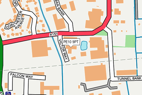
PE10 9PT is located in the Bourne Austerby electoral ward, within the local authority district of South Kesteven and the English Parliamentary constituency of Grantham and Stamford. The Sub Integrated Care Board (ICB) Location is NHS Lincolnshire ICB - 71E and the police force is Lincolnshire. This postcode has been in use since January 1993.


GetTheData
Source: OS OpenMap – Local (Ordnance Survey)
Source: OS VectorMap District (Ordnance Survey)
Licence: Open Government Licence (requires attribution)
| Easting | 510448 |
| Northing | 319281 |
| Latitude | 52.759854 |
| Longitude | -0.364729 |
GetTheData
Source: Open Postcode Geo
Licence: Open Government Licence
| Country | England |
| Postcode District | PE10 |
| ➜ PE10 open data dashboard ➜ See where PE10 is on a map ➜ Where is Bourne? | |
GetTheData
Source: Land Registry Price Paid Data
Licence: Open Government Licence
Elevation or altitude of PE10 9PT as distance above sea level:
| Metres | Feet | |
|---|---|---|
| Elevation | 10m | 33ft |
Elevation is measured from the approximate centre of the postcode, to the nearest point on an OS contour line from OS Terrain 50, which has contour spacing of ten vertical metres.
➜ How high above sea level am I? Find the elevation of your current position using your device's GPS.
GetTheData
Source: Open Postcode Elevation
Licence: Open Government Licence
| Ward | Bourne Austerby |
| Constituency | Grantham And Stamford |
GetTheData
Source: ONS Postcode Database
Licence: Open Government Licence
| January 2024 | Anti-social behaviour | On or near Cowslip Crescent | 457m |
| December 2023 | Anti-social behaviour | On or near Cowslip Crescent | 457m |
| July 2023 | Violence and sexual offences | On or near Dorchester Avenue | 264m |
| ➜ Get more crime data in our Crime section | |||
GetTheData
Source: data.police.uk
Licence: Open Government Licence
| Drummond Road (South Road) | Bourne | 363m |
| Holloway Avenue (South Road) | Bourne | 427m |
| Drummond Road (South Road) | Bourne | 449m |
| Holloway Avenue (South Road) | Bourne | 449m |
| Grammar School (South Road) | Bourne | 602m |
GetTheData
Source: NaPTAN
Licence: Open Government Licence
GetTheData
Source: ONS Postcode Database
Licence: Open Government Licence


➜ Get more ratings from the Food Standards Agency
GetTheData
Source: Food Standards Agency
Licence: FSA terms & conditions
| Last Collection | |||
|---|---|---|---|
| Location | Mon-Fri | Sat | Distance |
| Cherry Holt Rd-grovernor Ave | 17:30 | 12:00 | 176m |
| Graham Hill Way | 17:30 | 11:55 | 551m |
| Tillia Way | 16:00 | 12:45 | 585m |
GetTheData
Source: Dracos
Licence: Creative Commons Attribution-ShareAlike
| Facility | Distance |
|---|---|
| The Universal Fitness Centre Cherry Holt Road, Bourne Health and Fitness Gym, Studio | 415m |
| Willoughby School South Road, Bourne Sports Hall | 588m |
| Bourne Grammar School South Road, Bourne Health and Fitness Gym, Grass Pitches, Sports Hall, Outdoor Tennis Courts, Artificial Grass Pitch | 661m |
GetTheData
Source: Active Places
Licence: Open Government Licence
| School | Phase of Education | Distance |
|---|---|---|
| Willoughby Academy South Road, Bourne, PE10 9JD | Not applicable | 583m |
| Bourne Grammar School South Road, Bourne, PE10 9JE | Secondary | 661m |
| Bourne Abbey Church of England Primary Academy Abbey Road, Bourne, PE10 9EP | Primary | 894m |
GetTheData
Source: Edubase
Licence: Open Government Licence
The below table lists the International Territorial Level (ITL) codes (formerly Nomenclature of Territorial Units for Statistics (NUTS) codes) and Local Administrative Units (LAU) codes for PE10 9PT:
| ITL 1 Code | Name |
|---|---|
| TLF | East Midlands (England) |
| ITL 2 Code | Name |
| TLF3 | Lincolnshire |
| ITL 3 Code | Name |
| TLF30 | Lincolnshire CC |
| LAU 1 Code | Name |
| E07000141 | South Kesteven |
GetTheData
Source: ONS Postcode Directory
Licence: Open Government Licence
The below table lists the Census Output Area (OA), Lower Layer Super Output Area (LSOA), and Middle Layer Super Output Area (MSOA) for PE10 9PT:
| Code | Name | |
|---|---|---|
| OA | E00169403 | |
| LSOA | E01032997 | South Kesteven 011E |
| MSOA | E02005486 | South Kesteven 011 |
GetTheData
Source: ONS Postcode Directory
Licence: Open Government Licence
| PE10 9LS | Cherry Holt Road | 130m |
| PE10 0GR | Falcon Way | 170m |
| PE10 0BF | Eagle Road | 256m |
| PE10 9HU | Grosvenor Avenue | 258m |
| PE10 9HX | Dorchester Avenue | 268m |
| PE10 0FW | Peregrine Place | 273m |
| PE10 0BZ | Merlin Close | 298m |
| PE10 0DQ | Willoughby Road | 315m |
| PE10 0BX | Kestrel Drive | 320m |
| PE10 0DS | Mckenzie Court | 338m |
GetTheData
Source: Open Postcode Geo; Land Registry Price Paid Data
Licence: Open Government Licence