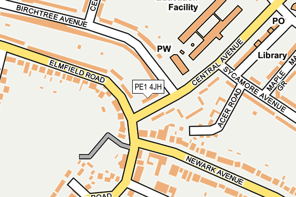
PE1 4JH lies on Central Avenue in Peterborough. PE1 4JH is located in the Dogsthorpe electoral ward, within the unitary authority of Peterborough and the English Parliamentary constituency of Peterborough. The Sub Integrated Care Board (ICB) Location is NHS Cambridgeshire and Peterborough ICB - 06H and the police force is Cambridgeshire. This postcode has been in use since January 1980.


GetTheData
Source: OS OpenMap – Local (Ordnance Survey)
Source: OS VectorMap District (Ordnance Survey)
Licence: Open Government Licence (requires attribution)
| Easting | 519718 |
| Northing | 300996 |
| Latitude | 52.593584 |
| Longitude | -0.234066 |
GetTheData
Source: Open Postcode Geo
Licence: Open Government Licence
| Street | Central Avenue |
| Town/City | Peterborough |
| Country | England |
| Postcode District | PE1 |
| ➜ PE1 open data dashboard ➜ See where PE1 is on a map ➜ Where is Peterborough? | |
GetTheData
Source: Land Registry Price Paid Data
Licence: Open Government Licence
Elevation or altitude of PE1 4JH as distance above sea level:
| Metres | Feet | |
|---|---|---|
| Elevation | 10m | 33ft |
Elevation is measured from the approximate centre of the postcode, to the nearest point on an OS contour line from OS Terrain 50, which has contour spacing of ten vertical metres.
➜ How high above sea level am I? Find the elevation of your current position using your device's GPS.
GetTheData
Source: Open Postcode Elevation
Licence: Open Government Licence
| Ward | Dogsthorpe |
| Constituency | Peterborough |
GetTheData
Source: ONS Postcode Database
Licence: Open Government Licence
| June 2022 | Public order | On or near Acer Road | 160m |
| June 2022 | Anti-social behaviour | On or near Acer Road | 160m |
| June 2022 | Vehicle crime | On or near Acer Road | 160m |
| ➜ Central Avenue crime map and outcomes | |||
GetTheData
Source: data.police.uk
Licence: Open Government Licence
| Methodist Church (Birchtree Ave) | Dogsthorpe | 43m |
| Elmfield Road | Garton End | 51m |
| Elmfield Road | Garton End | 64m |
| The Elm Tree (Garton End Road) | Garton End | 81m |
| The Elm Tree (Newark Avenue) | Garton End | 97m |
| Peterborough Station | 2.3km |
GetTheData
Source: NaPTAN
Licence: Open Government Licence
| Percentage of properties with Next Generation Access | 100.0% |
| Percentage of properties with Superfast Broadband | 100.0% |
| Percentage of properties with Ultrafast Broadband | 100.0% |
| Percentage of properties with Full Fibre Broadband | 100.0% |
Superfast Broadband is between 30Mbps and 300Mbps
Ultrafast Broadband is > 300Mbps
| Percentage of properties unable to receive 2Mbps | 0.0% |
| Percentage of properties unable to receive 5Mbps | 0.0% |
| Percentage of properties unable to receive 10Mbps | 0.0% |
| Percentage of properties unable to receive 30Mbps | 0.0% |
GetTheData
Source: Ofcom
Licence: Ofcom Terms of Use (requires attribution)
GetTheData
Source: ONS Postcode Database
Licence: Open Government Licence


➜ Get more ratings from the Food Standards Agency
GetTheData
Source: Food Standards Agency
Licence: FSA terms & conditions
| Last Collection | |||
|---|---|---|---|
| Location | Mon-Fri | Sat | Distance |
| Elmtree Public House | 18:00 | 12:45 | 123m |
| Central Avenue Post Office | 17:30 | 11:45 | 282m |
| Dogsthorpe Road | 18:15 | 12:45 | 523m |
GetTheData
Source: Dracos
Licence: Creative Commons Attribution-ShareAlike
| Facility | Distance |
|---|---|
| Dogsthorpe Academy Central Avenue, Peterborough Grass Pitches | 191m |
| The King's School Playing Field Garton End Road, Peterborough Artificial Grass Pitch, Grass Pitches | 247m |
| Millfield Autoparts Stadium Chestnut Avenue, Dogsthorpe, Peterborough Grass Pitches | 508m |
GetTheData
Source: Active Places
Licence: Open Government Licence
| School | Phase of Education | Distance |
|---|---|---|
| Dogsthorpe Academy Central Avenue, Dogsthorpe, Peterborough, PE1 4LH | Primary | 195m |
| Dogsthorpe Infant School Central Avenue, Dogsthorpe, Peterborough, PE1 4LH | Primary | 247m |
| The Beeches Independent School 45 Thorpe Road, Peterborough, PE3 6AN | Not applicable | 554m |
GetTheData
Source: Edubase
Licence: Open Government Licence
The below table lists the International Territorial Level (ITL) codes (formerly Nomenclature of Territorial Units for Statistics (NUTS) codes) and Local Administrative Units (LAU) codes for PE1 4JH:
| ITL 1 Code | Name |
|---|---|
| TLH | East |
| ITL 2 Code | Name |
| TLH1 | East Anglia |
| ITL 3 Code | Name |
| TLH11 | Peterborough |
| LAU 1 Code | Name |
| E06000031 | Peterborough |
GetTheData
Source: ONS Postcode Directory
Licence: Open Government Licence
The below table lists the Census Output Area (OA), Lower Layer Super Output Area (LSOA), and Middle Layer Super Output Area (MSOA) for PE1 4JH:
| Code | Name | |
|---|---|---|
| OA | E00078941 | |
| LSOA | E01015608 | Peterborough 008B |
| MSOA | E02003244 | Peterborough 008 |
GetTheData
Source: ONS Postcode Directory
Licence: Open Government Licence
| PE1 4JJ | Central Avenue | 41m |
| PE1 4JL | Central Avenue | 104m |
| PE1 4HW | Birchtree Avenue | 180m |
| PE1 4HP | Birchtree Avenue | 189m |
| PE1 4NP | Newark Avenue | 197m |
| PE1 4EP | Pyecroft | 199m |
| PE1 4HA | Elmfield Road | 204m |
| PE1 4JN | Sycamore Avenue | 217m |
| PE1 4EA | Ascot Drive | 222m |
| PE1 4NL | Newark Avenue | 228m |
GetTheData
Source: Open Postcode Geo; Land Registry Price Paid Data
Licence: Open Government Licence