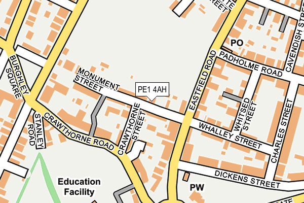
PE1 4AH lies on Leicester Terrace in Peterborough. PE1 4AH is located in the Central electoral ward, within the unitary authority of Peterborough and the English Parliamentary constituency of Peterborough. The Sub Integrated Care Board (ICB) Location is NHS Cambridgeshire and Peterborough ICB - 06H and the police force is Cambridgeshire. This postcode has been in use since September 1991.


GetTheData
Source: OS OpenMap – Local (Ordnance Survey)
Source: OS VectorMap District (Ordnance Survey)
Licence: Open Government Licence (requires attribution)
| Easting | 519662 |
| Northing | 299351 |
| Latitude | 52.578816 |
| Longitude | -0.235486 |
GetTheData
Source: Open Postcode Geo
Licence: Open Government Licence
| Street | Leicester Terrace |
| Town/City | Peterborough |
| Country | England |
| Postcode District | PE1 |
| ➜ PE1 open data dashboard ➜ See where PE1 is on a map ➜ Where is Peterborough? | |
GetTheData
Source: Land Registry Price Paid Data
Licence: Open Government Licence
Elevation or altitude of PE1 4AH as distance above sea level:
| Metres | Feet | |
|---|---|---|
| Elevation | 10m | 33ft |
Elevation is measured from the approximate centre of the postcode, to the nearest point on an OS contour line from OS Terrain 50, which has contour spacing of ten vertical metres.
➜ How high above sea level am I? Find the elevation of your current position using your device's GPS.
GetTheData
Source: Open Postcode Elevation
Licence: Open Government Licence
| Ward | Central |
| Constituency | Peterborough |
GetTheData
Source: ONS Postcode Database
Licence: Open Government Licence
| January 2024 | Anti-social behaviour | On or near Parking Area | 355m |
| January 2024 | Violence and sexual offences | On or near Parking Area | 355m |
| January 2024 | Violence and sexual offences | On or near Parking Area | 355m |
| ➜ Leicester Terrace crime map and outcomes | |||
GetTheData
Source: data.police.uk
Licence: Open Government Licence
| Whalley Street (Eastfield Road) | Eastfield | 78m |
| Whalley Street (Eastfield Road) | Eastfield | 82m |
| Crawthorne Road | Peterborough | 112m |
| Broadway Mansion (Broadway) | Peterborough | 208m |
| Broadway Mansion (Broadway) | Peterborough | 226m |
| Peterborough (Nene Valley Railway) | Woodston | 1,501m |
| Peterborough Station | 1.1km |
GetTheData
Source: NaPTAN
Licence: Open Government Licence
| Percentage of properties with Next Generation Access | 100.0% |
| Percentage of properties with Superfast Broadband | 100.0% |
| Percentage of properties with Ultrafast Broadband | 100.0% |
| Percentage of properties with Full Fibre Broadband | 0.0% |
Superfast Broadband is between 30Mbps and 300Mbps
Ultrafast Broadband is > 300Mbps
| Percentage of properties unable to receive 2Mbps | 0.0% |
| Percentage of properties unable to receive 5Mbps | 0.0% |
| Percentage of properties unable to receive 10Mbps | 0.0% |
| Percentage of properties unable to receive 30Mbps | 0.0% |
GetTheData
Source: Ofcom
Licence: Ofcom Terms of Use (requires attribution)
GetTheData
Source: ONS Postcode Database
Licence: Open Government Licence


➜ Get more ratings from the Food Standards Agency
GetTheData
Source: Food Standards Agency
Licence: FSA terms & conditions
| Last Collection | |||
|---|---|---|---|
| Location | Mon-Fri | Sat | Distance |
| Burghly Road-broadway Corner | 18:30 | 11:45 | 230m |
| Park Road-church Walk Corner | 18:30 | 11:45 | 349m |
| Church Walk-park Road | 356m | ||
GetTheData
Source: Dracos
Licence: Creative Commons Attribution-ShareAlike
| Facility | Distance |
|---|---|
| King's School Park Road, Peterborough Sports Hall | 398m |
| Trugym (Peterborough) (Closed) New Road, Peterborough Health and Fitness Gym, Studio | 441m |
| Ultra Bodies Gym & Fitness (Closed) Broadway, Peterborough Health and Fitness Gym | 605m |
GetTheData
Source: Active Places
Licence: Open Government Licence
| School | Phase of Education | Distance |
|---|---|---|
| The King's (The Cathedral) School Park Road, Peterborough, PE1 2UE | All-through | 388m |
| Lime Academy Abbotsmede Kingsley Road, Peterborough, PE1 5JS | Primary | 496m |
| Bishop Creighton Academy Vineyard Road, Peterborough, PE1 5DB | Primary | 716m |
GetTheData
Source: Edubase
Licence: Open Government Licence
The below table lists the International Territorial Level (ITL) codes (formerly Nomenclature of Territorial Units for Statistics (NUTS) codes) and Local Administrative Units (LAU) codes for PE1 4AH:
| ITL 1 Code | Name |
|---|---|
| TLH | East |
| ITL 2 Code | Name |
| TLH1 | East Anglia |
| ITL 3 Code | Name |
| TLH11 | Peterborough |
| LAU 1 Code | Name |
| E06000031 | Peterborough |
GetTheData
Source: ONS Postcode Directory
Licence: Open Government Licence
The below table lists the Census Output Area (OA), Lower Layer Super Output Area (LSOA), and Middle Layer Super Output Area (MSOA) for PE1 4AH:
| Code | Name | |
|---|---|---|
| OA | E00078892 | |
| LSOA | E01015602 | Peterborough 014C |
| MSOA | E02003250 | Peterborough 014 |
GetTheData
Source: ONS Postcode Directory
Licence: Open Government Licence
| PE1 4NB | Monument Court | 22m |
| PE1 4AQ | Monument Street | 23m |
| PE1 4AL | Gloucester Place | 32m |
| PE1 4AR | Eastfield Road | 61m |
| PE1 4AD | Crawthorne Street | 83m |
| PE1 4AG | Monument Street | 101m |
| PE1 4AS | Eastfield Road | 105m |
| PE1 4AP | Eastfield Road | 108m |
| PE1 4AN | Eastfield Road | 111m |
| PE1 4AE | Crawthorne Road | 123m |
GetTheData
Source: Open Postcode Geo; Land Registry Price Paid Data
Licence: Open Government Licence