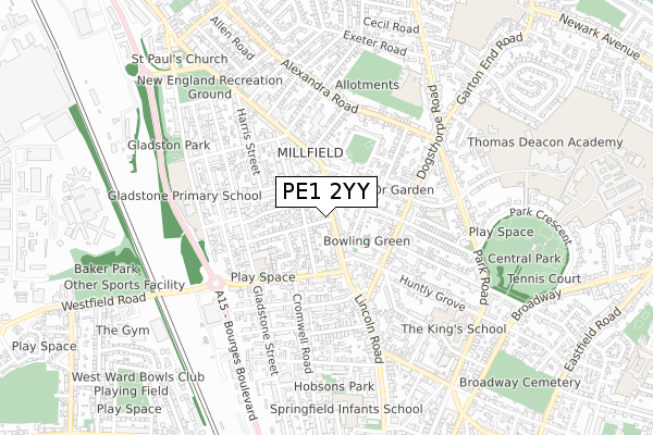
PE1 2YY lies on Lincoln Road in Peterborough. PE1 2YY is located in the North electoral ward, within the unitary authority of Peterborough and the English Parliamentary constituency of Peterborough. The Sub Integrated Care Board (ICB) Location is NHS Cambridgeshire and Peterborough ICB - 06H and the police force is Cambridgeshire. This postcode has been in use since June 1998.


GetTheData
Source: OS Open Zoomstack (Ordnance Survey)
Licence: Open Government Licence (requires attribution)
Attribution: Contains OS data © Crown copyright and database right 2024
Source: Open Postcode Geo
Licence: Open Government Licence (requires attribution)
Attribution: Contains OS data © Crown copyright and database right 2024; Contains Royal Mail data © Royal Mail copyright and database right 2024; Source: Office for National Statistics licensed under the Open Government Licence v.3.0
| Easting | 518899 |
| Northing | 300108 |
| Latitude | 52.585785 |
| Longitude | -0.246469 |
GetTheData
Source: Open Postcode Geo
Licence: Open Government Licence
| Street | Lincoln Road |
| Town/City | Peterborough |
| Country | England |
| Postcode District | PE1 |
| ➜ PE1 open data dashboard ➜ See where PE1 is on a map ➜ Where is Peterborough? | |
GetTheData
Source: Land Registry Price Paid Data
Licence: Open Government Licence
Elevation or altitude of PE1 2YY as distance above sea level:
| Metres | Feet | |
|---|---|---|
| Elevation | 10m | 33ft |
Elevation is measured from the approximate centre of the postcode, to the nearest point on an OS contour line from OS Terrain 50, which has contour spacing of ten vertical metres.
➜ How high above sea level am I? Find the elevation of your current position using your device's GPS.
GetTheData
Source: Open Postcode Elevation
Licence: Open Government Licence
| Ward | North |
| Constituency | Peterborough |
GetTheData
Source: ONS Postcode Database
Licence: Open Government Licence
| January 2024 | Violence and sexual offences | On or near Victoria Street | 165m |
| January 2024 | Burglary | On or near English Street | 400m |
| January 2024 | Violence and sexual offences | On or near English Street | 400m |
| ➜ Get more crime data in our Crime section | |||
GetTheData
Source: data.police.uk
Licence: Open Government Licence
| Cambridge Avenue (Lincoln Road) | Millfield | 18m |
| Cambridge Avenue (Lincoln Road) | Millfield | 37m |
| Alma Road (Lincoln Road) | Millfield | 124m |
| Alma Road (Lincoln Road) | Millfield | 153m |
| Huntly Grove (Dogsthorpe Road) | Millfield | 266m |
| Peterborough Station | 1.2km |
GetTheData
Source: NaPTAN
Licence: Open Government Licence
GetTheData
Source: ONS Postcode Database
Licence: Open Government Licence


➜ Get more ratings from the Food Standards Agency
GetTheData
Source: Food Standards Agency
Licence: FSA terms & conditions
| Last Collection | |||
|---|---|---|---|
| Location | Mon-Fri | Sat | Distance |
| Millfield Post Office | 18:00 | 12:15 | 214m |
| Huntley Grove | 18:15 | 12:30 | 324m |
| Dogsthorpe Road | 18:15 | 12:30 | 360m |
GetTheData
Source: Dracos
Licence: Creative Commons Attribution-ShareAlike
| Facility | Distance |
|---|---|
| Gladstone Park Community Centre Bourges Boulevard, Peterborough Sports Hall, Health and Fitness Gym, Grass Pitches, Artificial Grass Pitch | 525m |
| King's School Park Road, Peterborough Sports Hall | 681m |
| Central Park (Peterborough) Park Crescent, Peterborough Outdoor Tennis Courts | 803m |
GetTheData
Source: Active Places
Licence: Open Government Licence
| School | Phase of Education | Distance |
|---|---|---|
| Gladstone Primary Academy Gladstone Street, Peterborough, PE1 2BZ | Primary | 287m |
| Queen's Drive Infant School Queen's Drive West, Peterborough, PE1 2UU | Primary | 407m |
| All Saints' CofE (Aided) Primary School Dogsthorpe Road, Peterborough, PE1 3PW | Primary | 632m |
GetTheData
Source: Edubase
Licence: Open Government Licence
The below table lists the International Territorial Level (ITL) codes (formerly Nomenclature of Territorial Units for Statistics (NUTS) codes) and Local Administrative Units (LAU) codes for PE1 2YY:
| ITL 1 Code | Name |
|---|---|
| TLH | East |
| ITL 2 Code | Name |
| TLH1 | East Anglia |
| ITL 3 Code | Name |
| TLH11 | Peterborough |
| LAU 1 Code | Name |
| E06000031 | Peterborough |
GetTheData
Source: ONS Postcode Directory
Licence: Open Government Licence
The below table lists the Census Output Area (OA), Lower Layer Super Output Area (LSOA), and Middle Layer Super Output Area (MSOA) for PE1 2YY:
| Code | Name | |
|---|---|---|
| OA | E00078908 | |
| LSOA | E01015601 | Peterborough 012A |
| MSOA | E02003248 | Peterborough 012 |
GetTheData
Source: ONS Postcode Directory
Licence: Open Government Licence
| PE1 2JA | Cambridge Avenue | 48m |
| PE1 2PL | Lincoln Road | 51m |
| PE1 2NE | Lincoln Road | 74m |
| PE1 2JF | Silverwood Road | 85m |
| PE1 3BE | Highbury Street | 112m |
| PE1 2NQ | Lincoln Road | 115m |
| PE1 2JE | Silverwood Road | 120m |
| PE1 2PH | Lincoln Road | 137m |
| PE1 3BD | St Martins Street | 143m |
| PE1 2LT | Windmill Street | 156m |
GetTheData
Source: Open Postcode Geo; Land Registry Price Paid Data
Licence: Open Government Licence