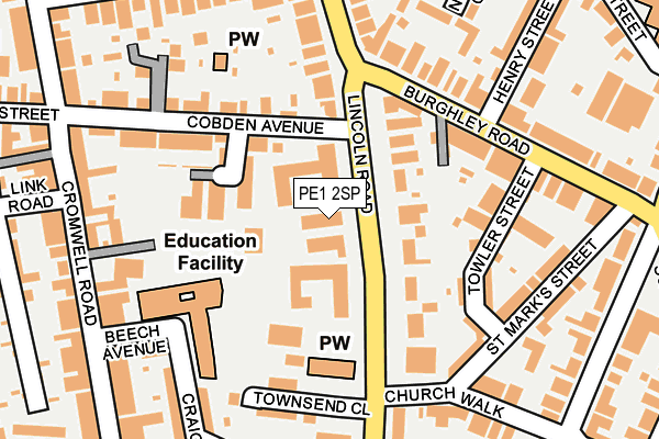
PE1 2SP is located in the Central electoral ward, within the unitary authority of Peterborough and the English Parliamentary constituency of Peterborough. The Sub Integrated Care Board (ICB) Location is NHS Cambridgeshire and Peterborough ICB - 06H and the police force is Cambridgeshire. This postcode has been in use since January 1980.


GetTheData
Source: OS OpenMap – Local (Ordnance Survey)
Source: OS VectorMap District (Ordnance Survey)
Licence: Open Government Licence (requires attribution)
| Easting | 519078 |
| Northing | 299458 |
| Latitude | 52.579905 |
| Longitude | -0.244061 |
GetTheData
Source: Open Postcode Geo
Licence: Open Government Licence
| Country | England |
| Postcode District | PE1 |
| ➜ PE1 open data dashboard ➜ See where PE1 is on a map ➜ Where is Peterborough? | |
GetTheData
Source: Land Registry Price Paid Data
Licence: Open Government Licence
Elevation or altitude of PE1 2SP as distance above sea level:
| Metres | Feet | |
|---|---|---|
| Elevation | 10m | 33ft |
Elevation is measured from the approximate centre of the postcode, to the nearest point on an OS contour line from OS Terrain 50, which has contour spacing of ten vertical metres.
➜ How high above sea level am I? Find the elevation of your current position using your device's GPS.
GetTheData
Source: Open Postcode Elevation
Licence: Open Government Licence
| Ward | Central |
| Constituency | Peterborough |
GetTheData
Source: ONS Postcode Database
Licence: Open Government Licence
| January 2024 | Anti-social behaviour | On or near Cromwell Road | 231m |
| January 2024 | Violence and sexual offences | On or near Cromwell Road | 231m |
| December 2023 | Violence and sexual offences | On or near Cromwell Road | 231m |
| ➜ Get more crime data in our Crime section | |||
GetTheData
Source: data.police.uk
Licence: Open Government Licence
| Cobden Avenue (Lincoln Road) | Peterborough | 71m |
| Cobden Avenue (Lincoln Road) | Peterborough | 87m |
| Burghley Road | Peterborough | 132m |
| Burghley Road | Peterborough | 245m |
| Craig Street (Lincoln Road) | Peterborough | 273m |
| Peterborough (Nene Valley Railway) | Woodston | 1,392m |
| Peterborough Station | 0.7km |
GetTheData
Source: NaPTAN
Licence: Open Government Licence
GetTheData
Source: ONS Postcode Database
Licence: Open Government Licence


➜ Get more ratings from the Food Standards Agency
GetTheData
Source: Food Standards Agency
Licence: FSA terms & conditions
| Last Collection | |||
|---|---|---|---|
| Location | Mon-Fri | Sat | Distance |
| Burghly Road | 18:30 | 11:45 | 146m |
| Cobden Street-cromwell Road | 18:15 | 11:45 | 282m |
| Church Walk-park Road | 299m | ||
GetTheData
Source: Dracos
Licence: Creative Commons Attribution-ShareAlike
| Facility | Distance |
|---|---|
| King's School Park Road, Peterborough Sports Hall | 396m |
| Ultra Bodies Gym & Fitness (Closed) Broadway, Peterborough Health and Fitness Gym | 560m |
| Trugym (Peterborough) (Closed) New Road, Peterborough Health and Fitness Gym, Studio | 618m |
GetTheData
Source: Active Places
Licence: Open Government Licence
| School | Phase of Education | Distance |
|---|---|---|
| The Beeches Primary School Beech Avenue, Peterborough, PE1 2EH | Primary | 175m |
| The King's (The Cathedral) School Park Road, Peterborough, PE1 2UE | All-through | 413m |
| Gladstone Primary Academy Gladstone Street, Peterborough, PE1 2BZ | Primary | 660m |
GetTheData
Source: Edubase
Licence: Open Government Licence
The below table lists the International Territorial Level (ITL) codes (formerly Nomenclature of Territorial Units for Statistics (NUTS) codes) and Local Administrative Units (LAU) codes for PE1 2SP:
| ITL 1 Code | Name |
|---|---|
| TLH | East |
| ITL 2 Code | Name |
| TLH1 | East Anglia |
| ITL 3 Code | Name |
| TLH11 | Peterborough |
| LAU 1 Code | Name |
| E06000031 | Peterborough |
GetTheData
Source: ONS Postcode Directory
Licence: Open Government Licence
The below table lists the Census Output Area (OA), Lower Layer Super Output Area (LSOA), and Middle Layer Super Output Area (MSOA) for PE1 2SP:
| Code | Name | |
|---|---|---|
| OA | E00171269 | |
| LSOA | E01015599 | Peterborough 014A |
| MSOA | E02003250 | Peterborough 014 |
GetTheData
Source: ONS Postcode Directory
Licence: Open Government Licence
| PE1 2SN | Lincoln Road | 50m |
| PE1 2RD | Lincoln Gate | 51m |
| PE1 2RE | Lincoln Gate | 51m |
| PE1 2SJ | Lincoln Road | 72m |
| PE1 2SH | Lincoln Road | 83m |
| PE1 2NL | Kimbolton Court | 108m |
| PE1 2TX | Towler Street | 147m |
| PE1 2NX | Cobden Avenue | 156m |
| PE1 2QE | Burghley Road | 158m |
| PE1 2QA | Burghley Road | 161m |
GetTheData
Source: Open Postcode Geo; Land Registry Price Paid Data
Licence: Open Government Licence