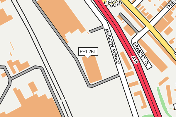
PE1 2BT is located in the North electoral ward, within the unitary authority of Peterborough and the English Parliamentary constituency of Peterborough. The Sub Integrated Care Board (ICB) Location is NHS Cambridgeshire and Peterborough ICB - 06H and the police force is Cambridgeshire. This postcode has been in use since October 2007.


GetTheData
Source: OS OpenMap – Local (Ordnance Survey)
Source: OS VectorMap District (Ordnance Survey)
Licence: Open Government Licence (requires attribution)
| Easting | 517953 |
| Northing | 300891 |
| Latitude | 52.593046 |
| Longitude | -0.260132 |
GetTheData
Source: Open Postcode Geo
Licence: Open Government Licence
| Country | England |
| Postcode District | PE1 |
| ➜ PE1 open data dashboard ➜ See where PE1 is on a map ➜ Where is Peterborough? | |
GetTheData
Source: Land Registry Price Paid Data
Licence: Open Government Licence
Elevation or altitude of PE1 2BT as distance above sea level:
| Metres | Feet | |
|---|---|---|
| Elevation | 20m | 66ft |
Elevation is measured from the approximate centre of the postcode, to the nearest point on an OS contour line from OS Terrain 50, which has contour spacing of ten vertical metres.
➜ How high above sea level am I? Find the elevation of your current position using your device's GPS.
GetTheData
Source: Open Postcode Elevation
Licence: Open Government Licence
| Ward | North |
| Constituency | Peterborough |
GetTheData
Source: ONS Postcode Database
Licence: Open Government Licence
| June 2022 | Violence and sexual offences | On or near Brassey Close | 173m |
| June 2022 | Shoplifting | On or near Brassey Close | 173m |
| June 2022 | Violence and sexual offences | On or near Lincoln Road | 248m |
| ➜ Get more crime data in our Crime section | |||
GetTheData
Source: data.police.uk
Licence: Open Government Licence
| Maskew Retail Park (Maskew Avenue) | New England | 103m |
| Burmer Road (Lincoln Road) | New England | 217m |
| Burmer Road (Lincoln Road) | New England | 238m |
| Boulevard Retail Park (Bourges Boulevard) | New England | 248m |
| Lincoln Road | New England | 258m |
| Peterborough Station | 2.1km |
GetTheData
Source: NaPTAN
Licence: Open Government Licence
GetTheData
Source: ONS Postcode Database
Licence: Open Government Licence


➜ Get more ratings from the Food Standards Agency
GetTheData
Source: Food Standards Agency
Licence: FSA terms & conditions
| Last Collection | |||
|---|---|---|---|
| Location | Mon-Fri | Sat | Distance |
| Crown Street-lincoln Road | 17:45 | 12:45 | 297m |
| Burmer Road | 17:45 | 13:00 | 353m |
| New England Post Office | 17:45 | 12:00 | 381m |
GetTheData
Source: Dracos
Licence: Creative Commons Attribution-ShareAlike
| Facility | Distance |
|---|---|
| Peterborough Sports Fc Lincoln Road, Peterborough Grass Pitches, Outdoor Tennis Courts | 345m |
| Bodyworx Gym Ltd Ivatt Way, Peterborough Health and Fitness Gym | 535m |
| Fulbridge Academy Keeton Road, Peterborough Grass Pitches, Artificial Grass Pitch, Sports Hall | 684m |
GetTheData
Source: Active Places
Licence: Open Government Licence
| School | Phase of Education | Distance |
|---|---|---|
| Ravensthorpe Primary School Brigstock Court, Peterborough, PE3 7NB | Primary | 652m |
| Fulbridge Academy Keeton Road, Peterborough, PE1 3JQ | Primary | 691m |
| Highlees Primary School Ashton Road, Westwood, Peterborough, PE3 7ER | Primary | 996m |
GetTheData
Source: Edubase
Licence: Open Government Licence
The below table lists the International Territorial Level (ITL) codes (formerly Nomenclature of Territorial Units for Statistics (NUTS) codes) and Local Administrative Units (LAU) codes for PE1 2BT:
| ITL 1 Code | Name |
|---|---|
| TLH | East |
| ITL 2 Code | Name |
| TLH1 | East Anglia |
| ITL 3 Code | Name |
| TLH11 | Peterborough |
| LAU 1 Code | Name |
| E06000031 | Peterborough |
GetTheData
Source: ONS Postcode Directory
Licence: Open Government Licence
The below table lists the Census Output Area (OA), Lower Layer Super Output Area (LSOA), and Middle Layer Super Output Area (MSOA) for PE1 2BT:
| Code | Name | |
|---|---|---|
| OA | E00078902 | |
| LSOA | E01015603 | Peterborough 010A |
| MSOA | E02003246 | Peterborough 010 |
GetTheData
Source: ONS Postcode Directory
Licence: Open Government Licence
| PE1 3HH | Lincoln Road | 211m |
| PE1 3HD | Lincoln Road | 248m |
| PE1 3HJ | Lincoln Road | 259m |
| PE1 2DU | Peppercorn Close | 304m |
| PE1 3NL | Gillwell Mews | 308m |
| PE1 3HE | Lincoln Road | 316m |
| PE1 3HA | Lincoln Road | 336m |
| PE1 2AU | Bourges Boulevard | 348m |
| PE1 3HU | Burmer Road | 378m |
| PE1 3HT | Burmer Road | 389m |
GetTheData
Source: Open Postcode Geo; Land Registry Price Paid Data
Licence: Open Government Licence