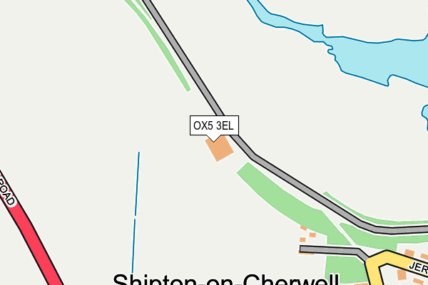
OX5 3EL lies on Bunkers Hill in Bunkers Hill, Kidlington. OX5 3EL is located in the Launton and Otmoor electoral ward, within the local authority district of Cherwell and the English Parliamentary constituency of Henley. The Sub Integrated Care Board (ICB) Location is NHS Buckinghamshire, Oxfordshire and Berkshire West ICB - 10Q and the police force is Thames Valley. This postcode has been in use since February 2003.


GetTheData
Source: OS OpenMap – Local (Ordnance Survey)
Source: OS VectorMap District (Ordnance Survey)
Licence: Open Government Licence (requires attribution)
| Easting | 447684 |
| Northing | 217010 |
| Latitude | 51.849656 |
| Longitude | -1.309148 |
GetTheData
Source: Open Postcode Geo
Licence: Open Government Licence
| Street | Bunkers Hill |
| Locality | Bunkers Hill |
| Town/City | Kidlington |
| Country | England |
| Postcode District | OX5 |
| ➜ OX5 open data dashboard ➜ See where OX5 is on a map | |
GetTheData
Source: Land Registry Price Paid Data
Licence: Open Government Licence
Elevation or altitude of OX5 3EL as distance above sea level:
| Metres | Feet | |
|---|---|---|
| Elevation | 80m | 262ft |
Elevation is measured from the approximate centre of the postcode, to the nearest point on an OS contour line from OS Terrain 50, which has contour spacing of ten vertical metres.
➜ How high above sea level am I? Find the elevation of your current position using your device's GPS.
GetTheData
Source: Open Postcode Elevation
Licence: Open Government Licence
| Ward | Launton And Otmoor |
| Constituency | Henley |
GetTheData
Source: ONS Postcode Database
Licence: Open Government Licence
| June 2022 | Public order | On or near Birchwood Drive | 320m |
| April 2022 | Anti-social behaviour | On or near Jerome Way | 421m |
| April 2022 | Anti-social behaviour | On or near Jerome Way | 421m |
| ➜ Bunkers Hill crime map and outcomes | |||
GetTheData
Source: data.police.uk
Licence: Open Government Licence
| Shipton On Cherwell Turn (Banbury Road) | Shipton-on-cherwell | 370m |
| Shipton On Cherwell Turn (Banbury Road) | Shipton-on-cherwell | 384m |
| Jerome Way | Shipton-on-cherwell | 501m |
| Bunkers Hill Turn (Banbury Road) | Bunkers Hill | 699m |
| Bunkers Hill Turn (Banbury Road) | Bunkers Hill | 738m |
| Tackley Station | 3.6km |
| Hanborough Station | 5.2km |
| Islip Station | 5.6km |
GetTheData
Source: NaPTAN
Licence: Open Government Licence
GetTheData
Source: ONS Postcode Database
Licence: Open Government Licence


➜ Get more ratings from the Food Standards Agency
GetTheData
Source: Food Standards Agency
Licence: FSA terms & conditions
| Last Collection | |||
|---|---|---|---|
| Location | Mon-Fri | Sat | Distance |
| Jerome Way | 17:00 | 08:00 | 405m |
| Shipton Manor | 17:15 | 08:00 | 515m |
| Bunkers Hill | 17:00 | 08:15 | 842m |
GetTheData
Source: Dracos
Licence: Creative Commons Attribution-ShareAlike
| Facility | Distance |
|---|---|
| Woodstock Open Air Pool Shipton Road, Woodstock Swimming Pool | 2.1km |
| Vida Health And Fitness Langford Lane, Kidlington Health and Fitness Gym, Studio, Squash Courts | 2.2km |
| The Marlborough Church Of England School Shipton Road, Woodstock Grass Pitches, Sports Hall, Outdoor Tennis Courts | 2.2km |
GetTheData
Source: Active Places
Licence: Open Government Licence
| School | Phase of Education | Distance |
|---|---|---|
| The Marlborough Church of England School Shipton Road, Woodstock, OX20 1LP | Secondary | 2.2km |
| Bletchingdon Parochial Church of England Primary School Whitemarsh Way, Bletchingdon, Kidlington, OX5 3FD | Primary | 2.5km |
| Woodstock Church of England Primary School Shipton Road, Woodstock, OX20 1LL | Primary | 2.5km |
GetTheData
Source: Edubase
Licence: Open Government Licence
The below table lists the International Territorial Level (ITL) codes (formerly Nomenclature of Territorial Units for Statistics (NUTS) codes) and Local Administrative Units (LAU) codes for OX5 3EL:
| ITL 1 Code | Name |
|---|---|
| TLJ | South East (England) |
| ITL 2 Code | Name |
| TLJ1 | Berkshire, Buckinghamshire and Oxfordshire |
| ITL 3 Code | Name |
| TLJ14 | Oxfordshire CC |
| LAU 1 Code | Name |
| E07000177 | Cherwell |
GetTheData
Source: ONS Postcode Directory
Licence: Open Government Licence
The below table lists the Census Output Area (OA), Lower Layer Super Output Area (LSOA), and Middle Layer Super Output Area (MSOA) for OX5 3EL:
| Code | Name | |
|---|---|---|
| OA | E00145198 | |
| LSOA | E01028498 | Cherwell 016C |
| MSOA | E02005936 | Cherwell 016 |
GetTheData
Source: ONS Postcode Directory
Licence: Open Government Licence
| OX5 1JP | Railway Cottage | 296m |
| OX5 1JW | 319m | |
| OX5 1JJ | Shipton Bottom | 323m |
| OX5 1NR | Birchwood Drive | 330m |
| OX5 1JN | 341m | |
| OX5 1JT | Jerome Way | 486m |
| OX5 1JL | 533m | |
| OX5 3BA | Bunkers Hill | 845m |
| OX20 1QQ | Upper Campsfield Road | 1212m |
| OX5 1JY | 1220m |
GetTheData
Source: Open Postcode Geo; Land Registry Price Paid Data
Licence: Open Government Licence