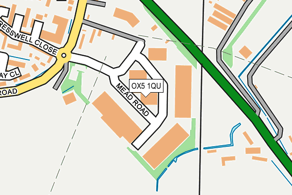
OX5 1QU is located in the Kidlington West electoral ward, within the local authority district of Cherwell and the English Parliamentary constituency of Oxford West and Abingdon. The Sub Integrated Care Board (ICB) Location is NHS Buckinghamshire, Oxfordshire and Berkshire West ICB - 10Q and the police force is Thames Valley. This postcode has been in use since December 1999.


GetTheData
Source: OS OpenMap – Local (Ordnance Survey)
Source: OS VectorMap District (Ordnance Survey)
Licence: Open Government Licence (requires attribution)
| Easting | 448380 |
| Northing | 211964 |
| Latitude | 51.804232 |
| Longitude | -1.299748 |
GetTheData
Source: Open Postcode Geo
Licence: Open Government Licence
| Country | England |
| Postcode District | OX5 |
| ➜ OX5 open data dashboard ➜ See where OX5 is on a map ➜ Where is Yarnton? | |
GetTheData
Source: Land Registry Price Paid Data
Licence: Open Government Licence
Elevation or altitude of OX5 1QU as distance above sea level:
| Metres | Feet | |
|---|---|---|
| Elevation | 60m | 197ft |
Elevation is measured from the approximate centre of the postcode, to the nearest point on an OS contour line from OS Terrain 50, which has contour spacing of ten vertical metres.
➜ How high above sea level am I? Find the elevation of your current position using your device's GPS.
GetTheData
Source: Open Postcode Elevation
Licence: Open Government Licence
| Ward | Kidlington West |
| Constituency | Oxford West And Abingdon |
GetTheData
Source: ONS Postcode Database
Licence: Open Government Licence
| June 2022 | Criminal damage and arson | On or near Bernard Close | 323m |
| June 2022 | Violence and sexual offences | On or near Marsh Close | 398m |
| June 2022 | Violence and sexual offences | On or near Marsh Close | 398m |
| ➜ Get more crime data in our Crime section | |||
GetTheData
Source: data.police.uk
Licence: Open Government Licence
| Great Close Road (Cassington Road) | Yarnton | 225m |
| Great Close Road (Cassington Road) | Yarnton | 231m |
| The Turnpike Ph (Woodstock Road) | Yarnton | 374m |
| The Turnpike Ph (Woodstock Road) | Yarnton | 399m |
| The Garth East (Woodstock Road) | Yarnton | 623m |
| Oxford Parkway Station | 1.7km |
| Islip Station | 4.9km |
GetTheData
Source: NaPTAN
Licence: Open Government Licence
GetTheData
Source: ONS Postcode Database
Licence: Open Government Licence


➜ Get more ratings from the Food Standards Agency
GetTheData
Source: Food Standards Agency
Licence: FSA terms & conditions
| Last Collection | |||
|---|---|---|---|
| Location | Mon-Fri | Sat | Distance |
| Great Close Road | 16:00 | 09:15 | 276m |
| Rutten Lane | 16:45 | 09:15 | 705m |
| Yarnton Post Office | 17:00 | 09:30 | 729m |
GetTheData
Source: Dracos
Licence: Creative Commons Attribution-ShareAlike
| Facility | Distance |
|---|---|
| Little Marsh Sports Ground Green Lane, Yarnton, Kidlington Grass Pitches | 379m |
| Yarnton Park Rutten Lane, Yarnton Grass Pitches | 832m |
| Stratfield Brake Frieze Way, Kidlington Grass Pitches | 1.3km |
GetTheData
Source: Active Places
Licence: Open Government Licence
| School | Phase of Education | Distance |
|---|---|---|
| William Fletcher Primary School Rutten Lane, Yarnton, Oxford, OX5 1LW | Primary | 1km |
| St Thomas More Catholic Primary School, Kidlington Oxford Road, Kidlington, OX5 1EA | Primary | 1.7km |
| West Kidlington Primary and Nursery School Oxford Road, Kidlington, OX5 1EA | Primary | 1.7km |
GetTheData
Source: Edubase
Licence: Open Government Licence
The below table lists the International Territorial Level (ITL) codes (formerly Nomenclature of Territorial Units for Statistics (NUTS) codes) and Local Administrative Units (LAU) codes for OX5 1QU:
| ITL 1 Code | Name |
|---|---|
| TLJ | South East (England) |
| ITL 2 Code | Name |
| TLJ1 | Berkshire, Buckinghamshire and Oxfordshire |
| ITL 3 Code | Name |
| TLJ14 | Oxfordshire CC |
| LAU 1 Code | Name |
| E07000177 | Cherwell |
GetTheData
Source: ONS Postcode Directory
Licence: Open Government Licence
The below table lists the Census Output Area (OA), Lower Layer Super Output Area (LSOA), and Middle Layer Super Output Area (MSOA) for OX5 1QU:
| Code | Name | |
|---|---|---|
| OA | E00145256 | |
| LSOA | E01028511 | Cherwell 019C |
| MSOA | E02005939 | Cherwell 019 |
GetTheData
Source: ONS Postcode Directory
Licence: Open Government Licence
| OX5 1FZ | Cresswell Close | 232m |
| OX5 1QH | Woodstock Road | 240m |
| OX5 1PQ | Woodstock Road | 247m |
| OX5 1QA | Cassington Road | 250m |
| OX5 1QW | Great Close Road | 316m |
| OX5 1FX | Cresswell Close | 320m |
| OX5 1QP | Bernard Close | 326m |
| OX5 1FS | Hayday Close | 354m |
| OX5 1QL | Marsh Close | 380m |
| OX5 1QN | Great Close Road | 425m |
GetTheData
Source: Open Postcode Geo; Land Registry Price Paid Data
Licence: Open Government Licence