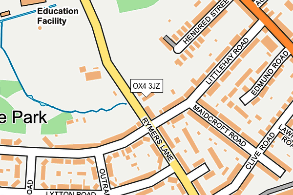
OX4 3JZ is located in the Temple Cowley electoral ward, within the local authority district of Oxford and the English Parliamentary constituency of Oxford East. The Sub Integrated Care Board (ICB) Location is NHS Buckinghamshire, Oxfordshire and Berkshire West ICB - 10Q and the police force is Thames Valley. This postcode has been in use since January 1980.


GetTheData
Source: OS OpenMap – Local (Ordnance Survey)
Source: OS VectorMap District (Ordnance Survey)
Licence: Open Government Licence (requires attribution)
| Easting | 453832 |
| Northing | 204403 |
| Latitude | 51.735765 |
| Longitude | -1.221835 |
GetTheData
Source: Open Postcode Geo
Licence: Open Government Licence
| Country | England |
| Postcode District | OX4 |
➜ See where OX4 is on a map ➜ Where is Oxford? | |
GetTheData
Source: Land Registry Price Paid Data
Licence: Open Government Licence
Elevation or altitude of OX4 3JZ as distance above sea level:
| Metres | Feet | |
|---|---|---|
| Elevation | 60m | 197ft |
Elevation is measured from the approximate centre of the postcode, to the nearest point on an OS contour line from OS Terrain 50, which has contour spacing of ten vertical metres.
➜ How high above sea level am I? Find the elevation of your current position using your device's GPS.
GetTheData
Source: Open Postcode Elevation
Licence: Open Government Licence
| Ward | Temple Cowley |
| Constituency | Oxford East |
GetTheData
Source: ONS Postcode Database
Licence: Open Government Licence
| Lytton Road (Rymers Lane) | Cowley | 118m |
| Maidcroft Road (Littlehay Road) | Cowley | 122m |
| Maidcroft Road (Littlehay Road) | Cowley | 131m |
| Lytton Road (Rymers Lane) | Cowley | 153m |
| Marsh Road (Cowley Road) | Cowley | 292m |
| Oxford Station | 3.9km |
GetTheData
Source: NaPTAN
Licence: Open Government Licence
GetTheData
Source: ONS Postcode Database
Licence: Open Government Licence


➜ Get more ratings from the Food Standards Agency
GetTheData
Source: Food Standards Agency
Licence: FSA terms & conditions
| Last Collection | |||
|---|---|---|---|
| Location | Mon-Fri | Sat | Distance |
| Clive Road, Cowley | 17:15 | 12:00 | 254m |
| Little Hay Road | 17:30 | 12:00 | 261m |
| Florence Park | 17:15 | 12:00 | 316m |
GetTheData
Source: Dracos
Licence: Creative Commons Attribution-ShareAlike
| Risk of OX4 3JZ flooding from rivers and sea | Medium |
| ➜ OX4 3JZ flood map | |
GetTheData
Source: Open Flood Risk by Postcode
Licence: Open Government Licence
The below table lists the International Territorial Level (ITL) codes (formerly Nomenclature of Territorial Units for Statistics (NUTS) codes) and Local Administrative Units (LAU) codes for OX4 3JZ:
| ITL 1 Code | Name |
|---|---|
| TLJ | South East (England) |
| ITL 2 Code | Name |
| TLJ1 | Berkshire, Buckinghamshire and Oxfordshire |
| ITL 3 Code | Name |
| TLJ14 | Oxfordshire CC |
| LAU 1 Code | Name |
| E07000178 | Oxford |
GetTheData
Source: ONS Postcode Directory
Licence: Open Government Licence
The below table lists the Census Output Area (OA), Lower Layer Super Output Area (LSOA), and Middle Layer Super Output Area (MSOA) for OX4 3JZ:
| Code | Name | |
|---|---|---|
| OA | E00145362 | |
| LSOA | E01028533 | Oxford 013C |
| MSOA | E02005952 | Oxford 013 |
GetTheData
Source: ONS Postcode Directory
Licence: Open Government Licence
| OX4 3EQ | Littlehay Road | 60m |
| OX4 3NP | Cornwallis Road | 95m |
| OX4 3JY | Rymers Lane | 110m |
| OX4 3LD | Kames Close | 122m |
| OX4 3LB | Rymers Lane | 141m |
| OX4 3PB | Lytton Road | 166m |
| OX4 3JW | Trevor Place | 168m |
| OX4 2ED | Hendred Street | 171m |
| OX4 2EE | Hendred Street | 174m |
| OX4 3EN | Maidcroft Road | 178m |
GetTheData
Source: Open Postcode Geo; Land Registry Price Paid Data
Licence: Open Government Licence