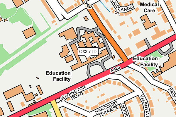
OX3 7TD is located in the Headington Hill & Northway electoral ward, within the local authority district of Oxford and the English Parliamentary constituency of Oxford East. The Sub Integrated Care Board (ICB) Location is NHS Buckinghamshire, Oxfordshire and Berkshire West ICB - 10Q and the police force is Thames Valley. This postcode has been in use since January 1980.


GetTheData
Source: OS OpenMap – Local (Ordnance Survey)
Source: OS VectorMap District (Ordnance Survey)
Licence: Open Government Licence (requires attribution)
| Easting | 453825 |
| Northing | 206828 |
| Latitude | 51.757561 |
| Longitude | -1.221581 |
GetTheData
Source: Open Postcode Geo
Licence: Open Government Licence
| Country | England |
| Postcode District | OX3 |
| ➜ OX3 open data dashboard ➜ See where OX3 is on a map ➜ Where is Oxford? | |
GetTheData
Source: Land Registry Price Paid Data
Licence: Open Government Licence
Elevation or altitude of OX3 7TD as distance above sea level:
| Metres | Feet | |
|---|---|---|
| Elevation | 100m | 328ft |
Elevation is measured from the approximate centre of the postcode, to the nearest point on an OS contour line from OS Terrain 50, which has contour spacing of ten vertical metres.
➜ How high above sea level am I? Find the elevation of your current position using your device's GPS.
GetTheData
Source: Open Postcode Elevation
Licence: Open Government Licence
| Ward | Headington Hill & Northway |
| Constituency | Oxford East |
GetTheData
Source: ONS Postcode Database
Licence: Open Government Licence
| June 2022 | Burglary | On or near Harcourt Terrace | 177m |
| June 2022 | Violence and sexual offences | On or near London Road | 239m |
| June 2022 | Violence and sexual offences | On or near London Road | 239m |
| ➜ Get more crime data in our Crime section | |||
GetTheData
Source: data.police.uk
Licence: Open Government Licence
| Headington School (Headington Road) | Headington | 66m |
| Headington School (Headington Road) | Headington | 99m |
| Headington School (Headley Way) | Headington | 102m |
| Headington School (Headley Way) | Headington | 114m |
| Brookes University (Headington Road) | Headington | 280m |
| Oxford Station | 3.4km |
GetTheData
Source: NaPTAN
Licence: Open Government Licence
Estimated total energy consumption in OX3 7TD by fuel type, 2015.
| Consumption (kWh) | 199,276 |
|---|---|
| Meter count | 7 |
| Mean (kWh/meter) | 28,468 |
| Median (kWh/meter) | 25,424 |
GetTheData
Source: Postcode level gas estimates: 2015 (experimental)
Source: Postcode level electricity estimates: 2015 (experimental)
Licence: Open Government Licence
GetTheData
Source: ONS Postcode Database
Licence: Open Government Licence


➜ Get more ratings from the Food Standards Agency
GetTheData
Source: Food Standards Agency
Licence: FSA terms & conditions
| Last Collection | |||
|---|---|---|---|
| Location | Mon-Fri | Sat | Distance |
| Grays Road | 17:15 | 11:30 | 169m |
| London Road West | 17:00 | 11:20 | 206m |
| Fortnam Close | 17:15 | 12:00 | 419m |
GetTheData
Source: Dracos
Licence: Creative Commons Attribution-ShareAlike
| Facility | Distance |
|---|---|
| Headington School Headington Road, Headington, Oxford Health and Fitness Gym, Sports Hall, Swimming Pool, Artificial Grass Pitch, Studio, Grass Pitches, Outdoor Tennis Courts | 0m |
| Rye St Antony School Pullens Lane, Headington, Oxford Sports Hall, Swimming Pool, Grass Pitches, Health and Fitness Gym, Outdoor Tennis Courts, Artificial Grass Pitch | 364m |
| Cheney School Cheney Lane, Headington, Oxford Sports Hall, Grass Pitches, Health and Fitness Gym, Outdoor Tennis Courts, Studio | 515m |
GetTheData
Source: Active Places
Licence: Open Government Licence
| School | Phase of Education | Distance |
|---|---|---|
| Headington School Headington Road, Oxford, OX3 7TD | Not applicable | 0m |
| Rye St Antony Pullen's Lane, Oxford, Oxford, OX3 0BY | Not applicable | 364m |
| Oxford Brookes University Headington Campus, Gipsy Lane, Headington, Oxford, OX3 0BP | Not applicable | 371m |
GetTheData
Source: Edubase
Licence: Open Government Licence
The below table lists the International Territorial Level (ITL) codes (formerly Nomenclature of Territorial Units for Statistics (NUTS) codes) and Local Administrative Units (LAU) codes for OX3 7TD:
| ITL 1 Code | Name |
|---|---|
| TLJ | South East (England) |
| ITL 2 Code | Name |
| TLJ1 | Berkshire, Buckinghamshire and Oxfordshire |
| ITL 3 Code | Name |
| TLJ14 | Oxfordshire CC |
| LAU 1 Code | Name |
| E07000178 | Oxford |
GetTheData
Source: ONS Postcode Directory
Licence: Open Government Licence
The below table lists the Census Output Area (OA), Lower Layer Super Output Area (LSOA), and Middle Layer Super Output Area (MSOA) for OX3 7TD:
| Code | Name | |
|---|---|---|
| OA | E00172562 | |
| LSOA | E01028540 | Oxford 006F |
| MSOA | E02005945 | Oxford 006 |
GetTheData
Source: ONS Postcode Directory
Licence: Open Government Licence
| OX3 7PS | Headington Road | 113m |
| OX3 7SU | Headley Way | 127m |
| OX3 7QF | Harcourt Terrace | 159m |
| OX3 7QB | Grays Road | 162m |
| OX3 7RX | Woodlands Road | 187m |
| OX3 7SP | London Road | 197m |
| OX3 7PL | Valentia Road | 217m |
| OX3 7RU | Woodlands Road | 222m |
| OX3 7PN | Valentia Road | 225m |
| OX3 7RY | Woodlands Close | 228m |
GetTheData
Source: Open Postcode Geo; Land Registry Price Paid Data
Licence: Open Government Licence