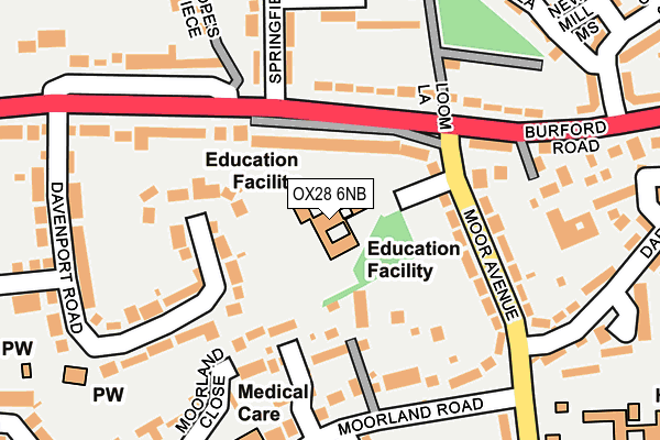
OX28 6NB is located in the Witney Central electoral ward, within the local authority district of West Oxfordshire and the English Parliamentary constituency of Witney. The Sub Integrated Care Board (ICB) Location is NHS Buckinghamshire, Oxfordshire and Berkshire West ICB - 10Q and the police force is Thames Valley. This postcode has been in use since June 2001.


GetTheData
Source: OS OpenMap – Local (Ordnance Survey)
Source: OS VectorMap District (Ordnance Survey)
Licence: Open Government Licence (requires attribution)
| Easting | 435019 |
| Northing | 210203 |
| Latitude | 51.789393 |
| Longitude | -1.493690 |
GetTheData
Source: Open Postcode Geo
Licence: Open Government Licence
| Country | England |
| Postcode District | OX28 |
| ➜ OX28 open data dashboard ➜ See where OX28 is on a map ➜ Where is Witney? | |
GetTheData
Source: Land Registry Price Paid Data
Licence: Open Government Licence
Elevation or altitude of OX28 6NB as distance above sea level:
| Metres | Feet | |
|---|---|---|
| Elevation | 90m | 295ft |
Elevation is measured from the approximate centre of the postcode, to the nearest point on an OS contour line from OS Terrain 50, which has contour spacing of ten vertical metres.
➜ How high above sea level am I? Find the elevation of your current position using your device's GPS.
GetTheData
Source: Open Postcode Elevation
Licence: Open Government Licence
| Ward | Witney Central |
| Constituency | Witney |
GetTheData
Source: ONS Postcode Database
Licence: Open Government Licence
| January 2024 | Public order | On or near Welch Way | 378m |
| December 2023 | Possession of weapons | On or near Police Station | 406m |
| December 2023 | Anti-social behaviour | On or near Police Station | 406m |
| ➜ Get more crime data in our Crime section | |||
GetTheData
Source: data.police.uk
Licence: Open Government Licence
| Moor Avenue | Witney | 154m |
| Moorland Road | Witney | 191m |
| Davenport Road | Witney | 247m |
| Springfield Oval | Witney | 305m |
| Moorland Road (Welch Way) | Witney | 357m |
GetTheData
Source: NaPTAN
Licence: Open Government Licence
GetTheData
Source: ONS Postcode Database
Licence: Open Government Licence


➜ Get more ratings from the Food Standards Agency
GetTheData
Source: Food Standards Agency
Licence: FSA terms & conditions
| Last Collection | |||
|---|---|---|---|
| Location | Mon-Fri | Sat | Distance |
| Burford Road | 16:45 | 09:30 | 265m |
| Corn Street | 17:00 | 12:00 | 707m |
| Witney Post Office | 18:30 | 12:30 | 728m |
GetTheData
Source: Dracos
Licence: Creative Commons Attribution-ShareAlike
| Facility | Distance |
|---|---|
| Pirate Fitness Bridge Street Mills Industrial Estate, Witney Health and Fitness Gym, Studio | 846m |
| The Henry Box School Playing Fields Ducklington Lane, Witney Grass Pitches | 883m |
| Palace Fitness Studio (Closed) Market Square, Witney Health and Fitness Gym | 897m |
GetTheData
Source: Active Places
Licence: Open Government Licence
| School | Phase of Education | Distance |
|---|---|---|
| Tower Hill Community Primary School Moor Avenue, Witney, OX28 6NB | Primary | 1m |
| The Batt Church of England Primary School Marlborough Lane, Corn Street, Witney, OX28 6DY | Primary | 739m |
| West Witney Primary School & Nursery Edington Road, Witney, OX28 5FZ | Primary | 982m |
GetTheData
Source: Edubase
Licence: Open Government Licence
The below table lists the International Territorial Level (ITL) codes (formerly Nomenclature of Territorial Units for Statistics (NUTS) codes) and Local Administrative Units (LAU) codes for OX28 6NB:
| ITL 1 Code | Name |
|---|---|
| TLJ | South East (England) |
| ITL 2 Code | Name |
| TLJ1 | Berkshire, Buckinghamshire and Oxfordshire |
| ITL 3 Code | Name |
| TLJ14 | Oxfordshire CC |
| LAU 1 Code | Name |
| E07000181 | West Oxfordshire |
GetTheData
Source: ONS Postcode Directory
Licence: Open Government Licence
The below table lists the Census Output Area (OA), Lower Layer Super Output Area (LSOA), and Middle Layer Super Output Area (MSOA) for OX28 6NB:
| Code | Name | |
|---|---|---|
| OA | E00146728 | |
| LSOA | E01028807 | West Oxfordshire 010A |
| MSOA | E02006002 | West Oxfordshire 010 |
GetTheData
Source: ONS Postcode Directory
Licence: Open Government Licence
| OX28 6DP | Burford Road | 89m |
| OX28 6LY | Crundel Rise | 134m |
| OX28 6DH | Burford Road | 141m |
| OX28 6LJ | Moor Avenue | 147m |
| OX28 6LF | Moorland Road | 155m |
| OX28 6LL | Moor Avenue | 161m |
| OX28 6EL | Davenport Road | 167m |
| OX28 6EJ | Davenport Road | 175m |
| OX28 6EF | Springfield Park | 183m |
| OX28 6DW | Burford Road | 194m |
GetTheData
Source: Open Postcode Geo; Land Registry Price Paid Data
Licence: Open Government Licence