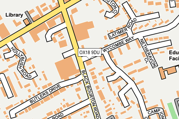
OX18 9DU is located in the Carterton South electoral ward, within the local authority district of West Oxfordshire and the English Parliamentary constituency of Witney. The Sub Integrated Care Board (ICB) Location is NHS Buckinghamshire, Oxfordshire and Berkshire West ICB - 10Q and the police force is Thames Valley. This postcode has been in use since February 2016.


GetTheData
Source: OS OpenMap – Local (Ordnance Survey)
Source: OS VectorMap District (Ordnance Survey)
Licence: Open Government Licence (requires attribution)
| Easting | 428184 |
| Northing | 206627 |
| Latitude | 51.757626 |
| Longitude | -1.593071 |
GetTheData
Source: Open Postcode Geo
Licence: Open Government Licence
| Country | England |
| Postcode District | OX18 |
| ➜ OX18 open data dashboard ➜ See where OX18 is on a map ➜ Where is Carterton? | |
GetTheData
Source: Land Registry Price Paid Data
Licence: Open Government Licence
Elevation or altitude of OX18 9DU as distance above sea level:
| Metres | Feet | |
|---|---|---|
| Elevation | 90m | 295ft |
Elevation is measured from the approximate centre of the postcode, to the nearest point on an OS contour line from OS Terrain 50, which has contour spacing of ten vertical metres.
➜ How high above sea level am I? Find the elevation of your current position using your device's GPS.
GetTheData
Source: Open Postcode Elevation
Licence: Open Government Licence
| Ward | Carterton South |
| Constituency | Witney |
GetTheData
Source: ONS Postcode Database
Licence: Open Government Licence
| January 2024 | Shoplifting | On or near Parking Area | 170m |
| January 2024 | Violence and sexual offences | On or near Parking Area | 283m |
| December 2023 | Drugs | On or near Parking Area | 283m |
| ➜ Get more crime data in our Crime section | |||
GetTheData
Source: data.police.uk
Licence: Open Government Licence
| Co-op (Black Bourton Road) | Carterton | 81m |
| Co-op (Black Bourton Road) | Carterton | 102m |
| Crossroads (Brize Norton Road) | Carterton | 220m |
| Town Hall (Alvescot Road) | Carterton | 246m |
| Marlborough Close (Milestone Road) | Carterton | 281m |
GetTheData
Source: NaPTAN
Licence: Open Government Licence
GetTheData
Source: ONS Postcode Database
Licence: Open Government Licence


➜ Get more ratings from the Food Standards Agency
GetTheData
Source: Food Standards Agency
Licence: FSA terms & conditions
| Last Collection | |||
|---|---|---|---|
| Location | Mon-Fri | Sat | Distance |
| Carterton Sorting Office | 18:00 | 11:30 | 21m |
| Oakfield Road | 16:15 | 11:30 | 477m |
| Rock Close | 16:30 | 11:30 | 553m |
GetTheData
Source: Dracos
Licence: Creative Commons Attribution-ShareAlike
| Facility | Distance |
|---|---|
| St John The Evangelist Church Carterton Burford Road, Carterton Sports Hall | 250m |
| Carterton Recreation Ground Alvescot Road Alvescot Road, Carterton Grass Pitches | 398m |
| Carterton Indoor Bowls Club Arkell Avenue, Carterton Indoor Bowls | 428m |
GetTheData
Source: Active Places
Licence: Open Government Licence
| School | Phase of Education | Distance |
|---|---|---|
| Gateway Primary School Netheravon Close, Carterton, OX18 3SF | Primary | 180m |
| Carterton Primary School Burford Road, Carterton, OX18 3AD | Primary | 563m |
| St Joseph's Catholic Primary School, Carterton Lawton Avenue, Carterton, OX18 3JY | Primary | 590m |
GetTheData
Source: Edubase
Licence: Open Government Licence
The below table lists the International Territorial Level (ITL) codes (formerly Nomenclature of Territorial Units for Statistics (NUTS) codes) and Local Administrative Units (LAU) codes for OX18 9DU:
| ITL 1 Code | Name |
|---|---|
| TLJ | South East (England) |
| ITL 2 Code | Name |
| TLJ1 | Berkshire, Buckinghamshire and Oxfordshire |
| ITL 3 Code | Name |
| TLJ14 | Oxfordshire CC |
| LAU 1 Code | Name |
| E07000181 | West Oxfordshire |
GetTheData
Source: ONS Postcode Directory
Licence: Open Government Licence
The below table lists the Census Output Area (OA), Lower Layer Super Output Area (LSOA), and Middle Layer Super Output Area (MSOA) for OX18 9DU:
| Code | Name | |
|---|---|---|
| OA | E00146559 | |
| LSOA | E01028774 | West Oxfordshire 014C |
| MSOA | E02006006 | West Oxfordshire 014 |
GetTheData
Source: ONS Postcode Directory
Licence: Open Government Licence
| OX18 3HQ | Black Bourton Road | 32m |
| OX18 3XL | Wycombe Way | 45m |
| OX18 3FQ | Butlers Drive | 70m |
| OX18 3YB | Queens Road | 90m |
| OX18 3HD | Black Bourton Road | 108m |
| OX18 3DJ | Black Bourton Road | 137m |
| OX18 3YD | Queens Road | 166m |
| OX18 3SF | Netheravon Close | 178m |
| OX18 3HH | Arlington Close | 187m |
| OX18 3XQ | Queens Road | 208m |
GetTheData
Source: Open Postcode Geo; Land Registry Price Paid Data
Licence: Open Government Licence