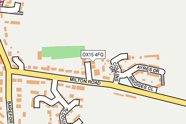
OX15 4FQ lies on Exchange Lane in Bloxham, Banbury. OX15 4FQ is located in the Adderbury, Bloxham and Bodicote electoral ward, within the local authority district of Cherwell and the English Parliamentary constituency of Banbury. The Sub Integrated Care Board (ICB) Location is NHS Buckinghamshire, Oxfordshire and Berkshire West ICB - 10Q and the police force is Thames Valley. This postcode has been in use since April 2012.


GetTheData
Source: OS OpenMap – Local (Ordnance Survey)
Source: OS VectorMap District (Ordnance Survey)
Licence: Open Government Licence (requires attribution)
| Easting | 443229 |
| Northing | 235345 |
| Latitude | 52.014855 |
| Longitude | -1.371522 |
GetTheData
Source: Open Postcode Geo
Licence: Open Government Licence
| Street | Exchange Lane |
| Locality | Bloxham |
| Town/City | Banbury |
| Country | England |
| Postcode District | OX15 |
| ➜ OX15 open data dashboard ➜ See where OX15 is on a map | |
GetTheData
Source: Land Registry Price Paid Data
Licence: Open Government Licence
Elevation or altitude of OX15 4FQ as distance above sea level:
| Metres | Feet | |
|---|---|---|
| Elevation | 120m | 394ft |
Elevation is measured from the approximate centre of the postcode, to the nearest point on an OS contour line from OS Terrain 50, which has contour spacing of ten vertical metres.
➜ How high above sea level am I? Find the elevation of your current position using your device's GPS.
GetTheData
Source: Open Postcode Elevation
Licence: Open Government Licence
| Ward | Adderbury, Bloxham And Bodicote |
| Constituency | Banbury |
GetTheData
Source: ONS Postcode Database
Licence: Open Government Licence
| November 2023 | Other theft | On or near Merrivale'S Lane | 467m |
| August 2023 | Violence and sexual offences | On or near Merrivale'S Lane | 467m |
| March 2023 | Burglary | On or near Merrivale'S Lane | 467m |
| ➜ Get more crime data in our Crime section | |||
GetTheData
Source: data.police.uk
Licence: Open Government Licence
| Manning Close (Barford Road) | Bloxham | 377m |
| Manning Close (Barford Road) | Bloxham | 384m |
| Church (Church Street) | Bloxham | 395m |
| Kings Road (South Newington Road) | Bloxham | 415m |
| Church (Church Street) | Bloxham | 420m |
GetTheData
Source: NaPTAN
Licence: Open Government Licence
| Percentage of properties with Next Generation Access | 100.0% |
| Percentage of properties with Superfast Broadband | 100.0% |
| Percentage of properties with Ultrafast Broadband | 100.0% |
| Percentage of properties with Full Fibre Broadband | 100.0% |
Superfast Broadband is between 30Mbps and 300Mbps
Ultrafast Broadband is > 300Mbps
| Percentage of properties unable to receive 2Mbps | 0.0% |
| Percentage of properties unable to receive 5Mbps | 0.0% |
| Percentage of properties unable to receive 10Mbps | 0.0% |
| Percentage of properties unable to receive 30Mbps | 0.0% |
GetTheData
Source: Ofcom
Licence: Ofcom Terms of Use (requires attribution)
GetTheData
Source: ONS Postcode Database
Licence: Open Government Licence


➜ Get more ratings from the Food Standards Agency
GetTheData
Source: Food Standards Agency
Licence: FSA terms & conditions
| Last Collection | |||
|---|---|---|---|
| Location | Mon-Fri | Sat | Distance |
| Bloxham Post Office | 17:00 | 09:30 | 785m |
| Horn Hill | 16:45 | 08:00 | 3,378m |
| Round Close | 16:45 | 09:15 | 3,573m |
GetTheData
Source: Dracos
Licence: Creative Commons Attribution-ShareAlike
| Facility | Distance |
|---|---|
| Bloxham Recreation Ground South Newington Road, Bloxham Grass Pitches | 720m |
| Bloxham Ex Servicemans Hall High Street, Bloxham, Banbury Sports Hall | 728m |
| Dewey Sports Centre Barley Close, Bloxham Sports Hall, Health and Fitness Gym, Artificial Grass Pitch, Grass Pitches, Squash Courts, Outdoor Tennis Courts, Studio | 742m |
GetTheData
Source: Active Places
Licence: Open Government Licence
| School | Phase of Education | Distance |
|---|---|---|
| Bloxham School Bloxham, Banbury, OX15 4PE | Not applicable | 869m |
| Bloxham Church of England Primary School Tadmarton Road, Bloxham, Banbury, OX15 4HP | Primary | 1.1km |
| The Warriner School Banbury Road, Bloxham, Banbury, OX15 4LJ | Secondary | 1.4km |
GetTheData
Source: Edubase
Licence: Open Government Licence
The below table lists the International Territorial Level (ITL) codes (formerly Nomenclature of Territorial Units for Statistics (NUTS) codes) and Local Administrative Units (LAU) codes for OX15 4FQ:
| ITL 1 Code | Name |
|---|---|
| TLJ | South East (England) |
| ITL 2 Code | Name |
| TLJ1 | Berkshire, Buckinghamshire and Oxfordshire |
| ITL 3 Code | Name |
| TLJ14 | Oxfordshire CC |
| LAU 1 Code | Name |
| E07000177 | Cherwell |
GetTheData
Source: ONS Postcode Directory
Licence: Open Government Licence
The below table lists the Census Output Area (OA), Lower Layer Super Output Area (LSOA), and Middle Layer Super Output Area (MSOA) for OX15 4FQ:
| Code | Name | |
|---|---|---|
| OA | E00145086 | |
| LSOA | E01028476 | Cherwell 008D |
| MSOA | E02005928 | Cherwell 008 |
GetTheData
Source: ONS Postcode Directory
Licence: Open Government Licence
| OX15 4FR | Collins Drive | 71m |
| OX15 4HD | Milton Road | 128m |
| OX15 4FT | Ayres Drive | 182m |
| OX15 4FP | Aldous Drive | 185m |
| OX15 4FS | Bridges Close | 185m |
| OX15 4EZ | Barford Road | 305m |
| OX15 4FL | Bloxham Court | 324m |
| OX15 4EX | Barford Road | 330m |
| OX15 4RA | Bradford Court | 347m |
| OX15 4GT | Wiggins Close | 351m |
GetTheData
Source: Open Postcode Geo; Land Registry Price Paid Data
Licence: Open Government Licence