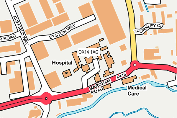
OX14 1AG is located in the Abingdon Fitzharris electoral ward, within the local authority district of Vale of White Horse and the English Parliamentary constituency of Oxford West and Abingdon. The Sub Integrated Care Board (ICB) Location is NHS Buckinghamshire, Oxfordshire and Berkshire West ICB - 10Q and the police force is Thames Valley. This postcode has been in use since January 1980.


GetTheData
Source: OS OpenMap – Local (Ordnance Survey)
Source: OS VectorMap District (Ordnance Survey)
Licence: Open Government Licence (requires attribution)
| Easting | 448375 |
| Northing | 197036 |
| Latitude | 51.670023 |
| Longitude | -1.301891 |
GetTheData
Source: Open Postcode Geo
Licence: Open Government Licence
| Country | England |
| Postcode District | OX14 |
| ➜ OX14 open data dashboard ➜ See where OX14 is on a map ➜ Where is Abingdon-on-Thames? | |
GetTheData
Source: Land Registry Price Paid Data
Licence: Open Government Licence
Elevation or altitude of OX14 1AG as distance above sea level:
| Metres | Feet | |
|---|---|---|
| Elevation | 60m | 197ft |
Elevation is measured from the approximate centre of the postcode, to the nearest point on an OS contour line from OS Terrain 50, which has contour spacing of ten vertical metres.
➜ How high above sea level am I? Find the elevation of your current position using your device's GPS.
GetTheData
Source: Open Postcode Elevation
Licence: Open Government Licence
| Ward | Abingdon Fitzharris |
| Constituency | Oxford West And Abingdon |
GetTheData
Source: ONS Postcode Database
Licence: Open Government Licence
| December 2023 | Violence and sexual offences | On or near Ock Mill Close | 344m |
| December 2023 | Violence and sexual offences | On or near Ock Mill Close | 344m |
| October 2023 | Other theft | On or near Nash Drive | 392m |
| ➜ Get more crime data in our Crime section | |||
GetTheData
Source: data.police.uk
Licence: Open Government Licence
| Community Hospital (Marcham Road) | Abingdon | 94m |
| Community Hospital (Marcham Road) | Abingdon | 135m |
| Colwell Drive | Abingdon | 193m |
| Colwell Drive | Abingdon | 201m |
| Abingdon Business Park (Wyndyke Furlong) | Abingdon | 361m |
| Radley Station | 4.6km |
| Culham Station | 4.9km |
| Appleford Station | 5.3km |
GetTheData
Source: NaPTAN
Licence: Open Government Licence
GetTheData
Source: ONS Postcode Database
Licence: Open Government Licence


➜ Get more ratings from the Food Standards Agency
GetTheData
Source: Food Standards Agency
Licence: FSA terms & conditions
| Last Collection | |||
|---|---|---|---|
| Location | Mon-Fri | Sat | Distance |
| Nuffield Way | 18:00 | 08:30 | 189m |
| Abingdon Business Park | 18:00 | 296m | |
| Blacklands Way | 18:00 | 08:30 | 301m |
GetTheData
Source: Dracos
Licence: Creative Commons Attribution-ShareAlike
| Facility | Distance |
|---|---|
| Anytime Fitness (Abingdon) Kimber Road, Kimber Road, Abingdon Health and Fitness Gym | 295m |
| The Gym Group (Oxford Abingdon) Marcham Road, Abingdon Health and Fitness Gym | 327m |
| Larkmead School Faringdon Road, Abingdon Grass Pitches, Sports Hall, Outdoor Tennis Courts | 775m |
GetTheData
Source: Active Places
Licence: Open Government Licence
| School | Phase of Education | Distance |
|---|---|---|
| The Unicorn School 20 Marcham Road, Abingdon, OX14 1AA | Not applicable | 368m |
| Larkmead School Faringdon Road, Abingdon, OX14 1RF | Secondary | 775m |
| Carswell Community Primary School Bostock Road, Carswell Primary School, Abingdon, OX14 1DP | Primary | 794m |
GetTheData
Source: Edubase
Licence: Open Government Licence
The below table lists the International Territorial Level (ITL) codes (formerly Nomenclature of Territorial Units for Statistics (NUTS) codes) and Local Administrative Units (LAU) codes for OX14 1AG:
| ITL 1 Code | Name |
|---|---|
| TLJ | South East (England) |
| ITL 2 Code | Name |
| TLJ1 | Berkshire, Buckinghamshire and Oxfordshire |
| ITL 3 Code | Name |
| TLJ14 | Oxfordshire CC |
| LAU 1 Code | Name |
| E07000180 | Vale of White Horse |
GetTheData
Source: ONS Postcode Directory
Licence: Open Government Licence
The below table lists the Census Output Area (OA), Lower Layer Super Output Area (LSOA), and Middle Layer Super Output Area (MSOA) for OX14 1AG:
| Code | Name | |
|---|---|---|
| OA | E00146158 | |
| LSOA | E01028698 | Vale of White Horse 006D |
| MSOA | E02005983 | Vale of White Horse 006 |
GetTheData
Source: ONS Postcode Directory
Licence: Open Government Licence
| OX14 1AF | Marcham Road | 114m |
| OX14 1UW | Willow Brook | 248m |
| OX14 1GQ | Thornley Close | 255m |
| OX14 1UL | Willow Brook | 311m |
| OX14 1TB | Willow Brook | 318m |
| OX14 5PW | Jenyns Court | 328m |
| OX14 1TD | Willow Brook | 332m |
| OX14 5PP | Chaunterell Way | 341m |
| OX14 1AL | Winterborne Road | 353m |
| OX14 1GN | Cemetery Road | 355m |
GetTheData
Source: Open Postcode Geo; Land Registry Price Paid Data
Licence: Open Government Licence