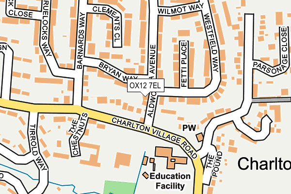
OX12 7EL is located in the Wantage Charlton electoral ward, within the local authority district of Vale of White Horse and the English Parliamentary constituency of Wantage. The Sub Integrated Care Board (ICB) Location is NHS Buckinghamshire, Oxfordshire and Berkshire West ICB - 10Q and the police force is Thames Valley. This postcode has been in use since January 1980.


GetTheData
Source: OS OpenMap – Local (Ordnance Survey)
Source: OS VectorMap District (Ordnance Survey)
Licence: Open Government Licence (requires attribution)
| Easting | 440882 |
| Northing | 188461 |
| Latitude | 51.593521 |
| Longitude | -1.411232 |
GetTheData
Source: Open Postcode Geo
Licence: Open Government Licence
| Country | England |
| Postcode District | OX12 |
| ➜ OX12 open data dashboard ➜ See where OX12 is on a map ➜ Where is Wantage? | |
GetTheData
Source: Land Registry Price Paid Data
Licence: Open Government Licence
Elevation or altitude of OX12 7EL as distance above sea level:
| Metres | Feet | |
|---|---|---|
| Elevation | 100m | 328ft |
Elevation is measured from the approximate centre of the postcode, to the nearest point on an OS contour line from OS Terrain 50, which has contour spacing of ten vertical metres.
➜ How high above sea level am I? Find the elevation of your current position using your device's GPS.
GetTheData
Source: Open Postcode Elevation
Licence: Open Government Licence
| Ward | Wantage Charlton |
| Constituency | Wantage |
GetTheData
Source: ONS Postcode Database
Licence: Open Government Licence
| June 2022 | Other theft | On or near Parsonage Close | 243m |
| June 2022 | Violence and sexual offences | On or near Palmers | 262m |
| June 2022 | Burglary | On or near Lyneham Court | 467m |
| ➜ Get more crime data in our Crime section | |||
GetTheData
Source: data.police.uk
Licence: Open Government Licence
| Aldworth Avenue (Charlton Village Road) | Charlton | 67m |
| Aldworth Avenue (Charlton Village Road) | Charlton | 76m |
| Harcourt Green (Harcourt Road) | Charlton | 315m |
| Harcourt Green (Harcourt Road) | Charlton | 316m |
| Fyfield Close (Charlton Road) | Charlton | 362m |
GetTheData
Source: NaPTAN
Licence: Open Government Licence
| Percentage of properties with Next Generation Access | 100.0% |
| Percentage of properties with Superfast Broadband | 100.0% |
| Percentage of properties with Ultrafast Broadband | 100.0% |
| Percentage of properties with Full Fibre Broadband | 0.0% |
Superfast Broadband is between 30Mbps and 300Mbps
Ultrafast Broadband is > 300Mbps
| Percentage of properties unable to receive 2Mbps | 0.0% |
| Percentage of properties unable to receive 5Mbps | 0.0% |
| Percentage of properties unable to receive 10Mbps | 0.0% |
| Percentage of properties unable to receive 30Mbps | 0.0% |
GetTheData
Source: Ofcom
Licence: Ofcom Terms of Use (requires attribution)
GetTheData
Source: ONS Postcode Database
Licence: Open Government Licence


➜ Get more ratings from the Food Standards Agency
GetTheData
Source: Food Standards Agency
Licence: FSA terms & conditions
| Last Collection | |||
|---|---|---|---|
| Location | Mon-Fri | Sat | Distance |
| Barnards Way Post Office | 17:00 | 11:30 | 172m |
| Portway The Quadrangle | 18:30 | 08:00 | 449m |
| Denchworth Road | 17:00 | 08:15 | 769m |
GetTheData
Source: Dracos
Licence: Creative Commons Attribution-ShareAlike
| Facility | Distance |
|---|---|
| Charlton Primary School Charlton Village Road, Charlton, Wantage Grass Pitches | 127m |
| Tugwell Field Reading Road, Wantage Grass Pitches | 459m |
| Wantage Primary Academy Rutherford Road, Rutherford Road, Wantage Grass Pitches | 578m |
GetTheData
Source: Active Places
Licence: Open Government Licence
| School | Phase of Education | Distance |
|---|---|---|
| Charlton Primary School Charlton Village Road, Wantage, OX12 7HG | Primary | 137m |
| Huckleberry Therapeutic School Manor Road, Wantage, Oxfordshire, OX12 8NE | Not applicable | 404m |
| Wantage Primary Academy Rutherford Road, Wantage Primary Academy, Wantage, OX12 7GQ | Primary | 578m |
GetTheData
Source: Edubase
Licence: Open Government Licence
The below table lists the International Territorial Level (ITL) codes (formerly Nomenclature of Territorial Units for Statistics (NUTS) codes) and Local Administrative Units (LAU) codes for OX12 7EL:
| ITL 1 Code | Name |
|---|---|
| TLJ | South East (England) |
| ITL 2 Code | Name |
| TLJ1 | Berkshire, Buckinghamshire and Oxfordshire |
| ITL 3 Code | Name |
| TLJ14 | Oxfordshire CC |
| LAU 1 Code | Name |
| E07000180 | Vale of White Horse |
GetTheData
Source: ONS Postcode Directory
Licence: Open Government Licence
The below table lists the Census Output Area (OA), Lower Layer Super Output Area (LSOA), and Middle Layer Super Output Area (MSOA) for OX12 7EL:
| Code | Name | |
|---|---|---|
| OA | E00146466 | |
| LSOA | E01028755 | Vale of White Horse 014A |
| MSOA | E02005991 | Vale of White Horse 014 |
GetTheData
Source: ONS Postcode Directory
Licence: Open Government Licence
| OX12 7EH | Bryan Way | 71m |
| OX12 7HQ | Charlton Village Road | 90m |
| OX12 7EN | Fettiplace | 125m |
| OX12 7HG | Charlton Village Road | 127m |
| OX12 7EW | Westfield Way | 141m |
| OX12 7EJ | Aldworth Avenue | 149m |
| OX12 7ED | Clement Close | 162m |
| OX12 7HW | Charlton Village Road | 170m |
| OX12 7HJ | The Chestnuts | 171m |
| OX12 7ER | Wilmot Way | 175m |
GetTheData
Source: Open Postcode Geo; Land Registry Price Paid Data
Licence: Open Government Licence