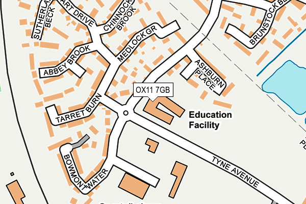
OX11 7GB is located in the Didcot North East electoral ward, within the local authority district of South Oxfordshire and the English Parliamentary constituency of Wantage. The Sub Integrated Care Board (ICB) Location is NHS Buckinghamshire, Oxfordshire and Berkshire West ICB - 10Q and the police force is Thames Valley. This postcode has been in use since June 1999.


GetTheData
Source: OS OpenMap – Local (Ordnance Survey)
Source: OS VectorMap District (Ordnance Survey)
Licence: Open Government Licence (requires attribution)
| Easting | 452651 |
| Northing | 191044 |
| Latitude | 51.615769 |
| Longitude | -1.240965 |
GetTheData
Source: Open Postcode Geo
Licence: Open Government Licence
| Country | England |
| Postcode District | OX11 |
| ➜ OX11 open data dashboard ➜ See where OX11 is on a map ➜ Where is Didcot? | |
GetTheData
Source: Land Registry Price Paid Data
Licence: Open Government Licence
Elevation or altitude of OX11 7GB as distance above sea level:
| Metres | Feet | |
|---|---|---|
| Elevation | 60m | 197ft |
Elevation is measured from the approximate centre of the postcode, to the nearest point on an OS contour line from OS Terrain 50, which has contour spacing of ten vertical metres.
➜ How high above sea level am I? Find the elevation of your current position using your device's GPS.
GetTheData
Source: Open Postcode Elevation
Licence: Open Government Licence
| Ward | Didcot North East |
| Constituency | Wantage |
GetTheData
Source: ONS Postcode Database
Licence: Open Government Licence
| November 2023 | Anti-social behaviour | On or near Rawthey Avenue | 478m |
| October 2023 | Criminal damage and arson | On or near Rawthey Avenue | 478m |
| October 2023 | Other theft | On or near Rawthey Avenue | 478m |
| ➜ Get more crime data in our Crime section | |||
GetTheData
Source: data.police.uk
Licence: Open Government Licence
| Ladygrove Park Primary School (Avon Way) | Ladygrove | 28m |
| Ladygrove Park Primary School (Avon Way) | Ladygrove | 38m |
| Brunstock Beck (Avon Way) | Ladygrove | 195m |
| Brunstock Beck (Avon Way) | Ladygrove | 228m |
| Dagdale Drive (Avon Way) | Ladygrove | 318m |
| Didcot Parkway Station | 0.6km |
| Appleford Station | 2.7km |
| Culham Station | 4.2km |
GetTheData
Source: NaPTAN
Licence: Open Government Licence
GetTheData
Source: ONS Postcode Database
Licence: Open Government Licence


➜ Get more ratings from the Food Standards Agency
GetTheData
Source: Food Standards Agency
Licence: FSA terms & conditions
| Last Collection | |||
|---|---|---|---|
| Location | Mon-Fri | Sat | Distance |
| Tyne Avenue | 16:00 | 08:00 | 352m |
| Tamar Way | 17:30 | 08:00 | 479m |
| Mersey Way | 16:00 | 08:00 | 713m |
GetTheData
Source: Dracos
Licence: Creative Commons Attribution-ShareAlike
| Facility | Distance |
|---|---|
| Ladygrove Park Primary School Avon Way, Didcot Grass Pitches | 0m |
| Npower Loop Meadow Stadium Bowmont Water, Didcot Grass Pitches | 143m |
| Willowbrook Leisure Centre Bowmont Water, Didcot Sports Hall, Health and Fitness Gym, Studio | 170m |
GetTheData
Source: Active Places
Licence: Open Government Licence
| School | Phase of Education | Distance |
|---|---|---|
| Ladygrove Park Primary School Avon Way, Didcot, OX11 7GB | Primary | 1m |
| Lydalls Nursery School Lydalls Road, Didcot, OX11 7HX | Nursery | 674m |
| All Saints Church of England Primary School Tamar Way, Didcot, OX11 7QH | Primary | 977m |
GetTheData
Source: Edubase
Licence: Open Government Licence
The below table lists the International Territorial Level (ITL) codes (formerly Nomenclature of Territorial Units for Statistics (NUTS) codes) and Local Administrative Units (LAU) codes for OX11 7GB:
| ITL 1 Code | Name |
|---|---|
| TLJ | South East (England) |
| ITL 2 Code | Name |
| TLJ1 | Berkshire, Buckinghamshire and Oxfordshire |
| ITL 3 Code | Name |
| TLJ14 | Oxfordshire CC |
| LAU 1 Code | Name |
| E07000179 | South Oxfordshire |
GetTheData
Source: ONS Postcode Directory
Licence: Open Government Licence
The below table lists the Census Output Area (OA), Lower Layer Super Output Area (LSOA), and Middle Layer Super Output Area (MSOA) for OX11 7GB:
| Code | Name | |
|---|---|---|
| OA | E00145815 | |
| LSOA | E01028625 | South Oxfordshire 009A |
| MSOA | E02005966 | South Oxfordshire 009 |
GetTheData
Source: ONS Postcode Directory
Licence: Open Government Licence
| OX11 7XZ | Blakehope Burn | 65m |
| OX11 7FW | Nunney Brook | 77m |
| OX11 7FN | Ashburn Place | 117m |
| OX11 7XY | Medlock Grove | 127m |
| OX11 7XX | Dart Drive | 154m |
| OX11 7FZ | Tarret Burn | 165m |
| OX11 7GF | Bowmont Water | 183m |
| OX11 7XU | Chinnock Brook | 185m |
| OX11 7FY | Abbey Brook | 187m |
| OX11 7GE | Bowmont Water | 195m |
GetTheData
Source: Open Postcode Geo; Land Registry Price Paid Data
Licence: Open Government Licence