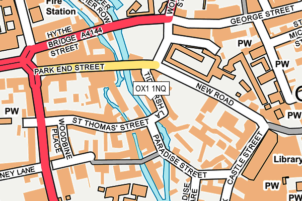
OX1 1NQ is located in the Osney & St Thomas electoral ward, within the local authority district of Oxford and the English Parliamentary constituency of Oxford East. The Sub Integrated Care Board (ICB) Location is NHS Buckinghamshire, Oxfordshire and Berkshire West ICB - 10Q and the police force is Thames Valley. This postcode has been in use since January 1980.


GetTheData
Source: OS OpenMap – Local (Ordnance Survey)
Source: OS VectorMap District (Ordnance Survey)
Licence: Open Government Licence (requires attribution)
| Easting | 450901 |
| Northing | 206194 |
| Latitude | 51.752134 |
| Longitude | -1.264033 |
GetTheData
Source: Open Postcode Geo
Licence: Open Government Licence
| Country | England |
| Postcode District | OX1 |
| ➜ OX1 open data dashboard ➜ See where OX1 is on a map ➜ Where is Oxford? | |
GetTheData
Source: Land Registry Price Paid Data
Licence: Open Government Licence
Elevation or altitude of OX1 1NQ as distance above sea level:
| Metres | Feet | |
|---|---|---|
| Elevation | 60m | 197ft |
Elevation is measured from the approximate centre of the postcode, to the nearest point on an OS contour line from OS Terrain 50, which has contour spacing of ten vertical metres.
➜ How high above sea level am I? Find the elevation of your current position using your device's GPS.
GetTheData
Source: Open Postcode Elevation
Licence: Open Government Licence
| Ward | Osney & St Thomas |
| Constituency | Oxford East |
GetTheData
Source: ONS Postcode Database
Licence: Open Government Licence
| January 2024 | Criminal damage and arson | On or near Parking Area | 273m |
| January 2024 | Other theft | On or near Parking Area | 273m |
| January 2024 | Violence and sexual offences | On or near Parking Area | 273m |
| ➜ Get more crime data in our Crime section | |||
GetTheData
Source: data.police.uk
Licence: Open Government Licence
| New Road | Oxford City Centre | 82m |
| New Road | Oxford City Centre | 91m |
| Park End Street | Oxford City Centre | 108m |
| New Road | Oxford City Centre | 115m |
| County Hall (New Road) | Oxford City Centre | 131m |
| Oxford Station | 0.4km |
GetTheData
Source: NaPTAN
Licence: Open Government Licence
GetTheData
Source: ONS Postcode Database
Licence: Open Government Licence


➜ Get more ratings from the Food Standards Agency
GetTheData
Source: Food Standards Agency
Licence: FSA terms & conditions
| Last Collection | |||
|---|---|---|---|
| Location | Mon-Fri | Sat | Distance |
| Paradise Street | 17:30 | 12:00 | 68m |
| George Street | 18:30 | 12:00 | 225m |
| Royal Mail House | 19:15 | 12:00 | 273m |
GetTheData
Source: Dracos
Licence: Creative Commons Attribution-ShareAlike
| Facility | Distance |
|---|---|
| Worcester College Walton Street, Oxford Health and Fitness Gym, Grass Pitches, Outdoor Tennis Courts | 232m |
| Buzz Gym (Oxford) Castle Street, Oxford Health and Fitness Gym | 267m |
| Puregym (Oxford Central) 16 -17 St Ebbes Street, Oxford Swimming Pool, Health and Fitness Gym, Studio | 384m |
GetTheData
Source: Active Places
Licence: Open Government Licence
| School | Phase of Education | Distance |
|---|---|---|
| Carfax College 39-42 Hythe Bridge Street, Oxford, OX1 2EP | Not applicable | 204m |
| Activate Learning Oxpens Road, Oxford, OX1 1SA | 16 plus | 290m |
| The Eckersley School of English 14 Friars Entry, Oxford, OX1 2BZ | Not applicable | 345m |
GetTheData
Source: Edubase
Licence: Open Government Licence
The below table lists the International Territorial Level (ITL) codes (formerly Nomenclature of Territorial Units for Statistics (NUTS) codes) and Local Administrative Units (LAU) codes for OX1 1NQ:
| ITL 1 Code | Name |
|---|---|
| TLJ | South East (England) |
| ITL 2 Code | Name |
| TLJ1 | Berkshire, Buckinghamshire and Oxfordshire |
| ITL 3 Code | Name |
| TLJ14 | Oxfordshire CC |
| LAU 1 Code | Name |
| E07000178 | Oxford |
GetTheData
Source: ONS Postcode Directory
Licence: Open Government Licence
The below table lists the Census Output Area (OA), Lower Layer Super Output Area (LSOA), and Middle Layer Super Output Area (MSOA) for OX1 1NQ:
| Code | Name | |
|---|---|---|
| OA | E00172575 | |
| LSOA | E01028521 | Oxford 008A |
| MSOA | E02005947 | Oxford 008 |
GetTheData
Source: ONS Postcode Directory
Licence: Open Government Licence
| OX1 1JZ | Lower Fisher Row | 32m |
| OX1 1AZ | Tidmarsh Lane | 41m |
| OX1 1HT | Fisher Row | 60m |
| OX1 1HQ | St Thomas Street | 83m |
| OX1 1HD | Woodins Way | 97m |
| OX1 1JE | St Thomas Street | 106m |
| OX1 1JD | Park End Street | 124m |
| OX1 1HH | Park End Street | 138m |
| OX1 1HF | Woodins Way | 140m |
| OX1 1JW | Hamel Walk | 143m |
GetTheData
Source: Open Postcode Geo; Land Registry Price Paid Data
Licence: Open Government Licence