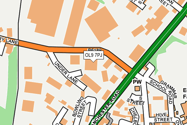
OL9 7PJ is located in the Chadderton South electoral ward, within the metropolitan district of Oldham and the English Parliamentary constituency of Oldham West and Royton. The Sub Integrated Care Board (ICB) Location is NHS Greater Manchester ICB - 00Y and the police force is Greater Manchester. This postcode has been in use since July 1983.


GetTheData
Source: OS OpenMap – Local (Ordnance Survey)
Source: OS VectorMap District (Ordnance Survey)
Licence: Open Government Licence (requires attribution)
| Easting | 390691 |
| Northing | 403058 |
| Latitude | 53.524120 |
| Longitude | -2.141882 |
GetTheData
Source: Open Postcode Geo
Licence: Open Government Licence
| Country | England |
| Postcode District | OL9 |
| ➜ OL9 open data dashboard ➜ See where OL9 is on a map ➜ Where is Chadderton? | |
GetTheData
Source: Land Registry Price Paid Data
Licence: Open Government Licence
Elevation or altitude of OL9 7PJ as distance above sea level:
| Metres | Feet | |
|---|---|---|
| Elevation | 120m | 394ft |
Elevation is measured from the approximate centre of the postcode, to the nearest point on an OS contour line from OS Terrain 50, which has contour spacing of ten vertical metres.
➜ How high above sea level am I? Find the elevation of your current position using your device's GPS.
GetTheData
Source: Open Postcode Elevation
Licence: Open Government Licence
| Ward | Chadderton South |
| Constituency | Oldham West And Royton |
GetTheData
Source: ONS Postcode Database
Licence: Open Government Licence
| Drury Ln/Under Ln (Drury Ln) | White Gate | 63m |
| Drury Ln/Under Ln (Drury Ln) | White Gate | 77m |
| Manchester Rd/Drury Ln (Manchester Rd) | White Gate | 133m |
| Manchester Rd/Drury Ln (Manchester Rd) | White Gate | 189m |
| Manchester Rd/Clowes St (Manchester Rd) | Hollinwood | 264m |
| South Chadderton (Manchester Metrolink) (Canal St) | White Gate | 349m |
| Hollinwood (Manchester Metrolink) (Railway Road) | Hollinwood | 604m |
| Failsworth (Manchester Metrolink) (Hardman Lane) | Failsworth | 2,050m |
| Moston Station | 1.9km |
| Mills Hill (Manchester) Station | 3.6km |
| Ashton-under-Lyne Station | 4.8km |
GetTheData
Source: NaPTAN
Licence: Open Government Licence
| Median download speed | 24.4Mbps |
| Average download speed | 36.3Mbps |
| Maximum download speed | 80.00Mbps |
| Median upload speed | 5.5Mbps |
| Average upload speed | 8.3Mbps |
| Maximum upload speed | 20.00Mbps |
GetTheData
Source: Ofcom
Licence: Ofcom Terms of Use (requires attribution)
GetTheData
Source: ONS Postcode Database
Licence: Open Government Licence


➜ Get more ratings from the Food Standards Agency
GetTheData
Source: Food Standards Agency
Licence: FSA terms & conditions
| Last Collection | |||
|---|---|---|---|
| Location | Mon-Fri | Sat | Distance |
| Corner Of Chapel Road | 17:30 | 11:55 | 620m |
| Sycamore Avenue | 17:35 | 12:10 | 798m |
| Morrisons | 17:40 | 12:00 | 841m |
GetTheData
Source: Dracos
Licence: Creative Commons Attribution-ShareAlike
| Facility | Distance |
|---|---|
| The Gym Group (Oldham) Drury Lane, Chadderton, Oldham Health and Fitness Gym | 140m |
| Chapel Road Synthetic Pitch Grammar School Road, Oldham Artificial Grass Pitch | 258m |
| Oldham Athletic Afc (Chapel Road Training Ground) Chapel Road, Oldham Grass Pitches | 318m |
GetTheData
Source: Active Places
Licence: Open Government Licence
| School | Phase of Education | Distance |
|---|---|---|
| St Margaret's CofE Junior Infant and Nursery School Hive Street, Hollinwood, Oldham, OL8 4QS | Primary | 284m |
| Corpus Christi RC Primary School Stanley Road, Chadderton, Oldham, OL9 7HA | Primary | 544m |
| Stanley Road Primary School Derby Street, Chadderton, Oldham, OL9 7HX | Primary | 591m |
GetTheData
Source: Edubase
Licence: Open Government Licence
The below table lists the International Territorial Level (ITL) codes (formerly Nomenclature of Territorial Units for Statistics (NUTS) codes) and Local Administrative Units (LAU) codes for OL9 7PJ:
| ITL 1 Code | Name |
|---|---|
| TLD | North West (England) |
| ITL 2 Code | Name |
| TLD3 | Greater Manchester |
| ITL 3 Code | Name |
| TLD37 | Greater Manchester North East |
| LAU 1 Code | Name |
| E08000004 | Oldham |
GetTheData
Source: ONS Postcode Directory
Licence: Open Government Licence
The below table lists the Census Output Area (OA), Lower Layer Super Output Area (LSOA), and Middle Layer Super Output Area (MSOA) for OL9 7PJ:
| Code | Name | |
|---|---|---|
| OA | E00027220 | |
| LSOA | E01005376 | Oldham 031D |
| MSOA | E02001128 | Oldham 031 |
GetTheData
Source: ONS Postcode Directory
Licence: Open Government Licence
| OL8 4QY | Manchester Road | 173m |
| OL8 4RB | Moorfield Road | 182m |
| OL8 4RF | Manchester Road | 192m |
| OL8 4RD | Parkfield Avenue | 231m |
| OL8 4QU | Byron Street | 241m |
| OL8 4QT | Byron Street | 245m |
| OL9 7HQ | Wharf Street | 260m |
| OL9 7PA | Vine Street | 272m |
| OL9 7HG | Albert Street | 278m |
| OL8 4QS | Hive Street | 294m |
GetTheData
Source: Open Postcode Geo; Land Registry Price Paid Data
Licence: Open Government Licence