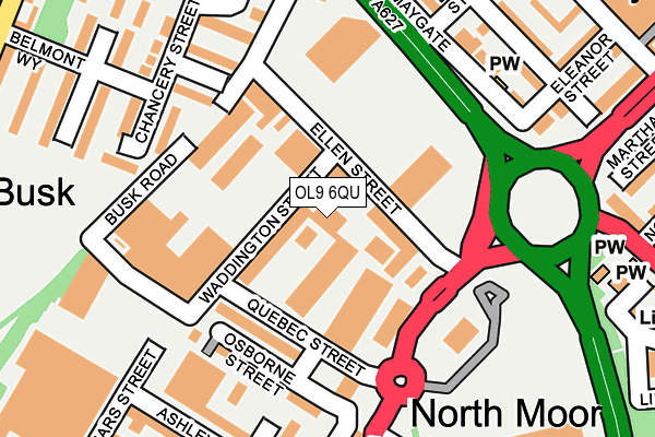
OL9 6QU is located in the Coldhurst electoral ward, within the metropolitan district of Oldham and the English Parliamentary constituency of Oldham West and Royton. The Sub Integrated Care Board (ICB) Location is NHS Greater Manchester ICB - 00Y and the police force is Greater Manchester. This postcode has been in use since December 1994.


GetTheData
Source: OS OpenMap – Local (Ordnance Survey)
Source: OS VectorMap District (Ordnance Survey)
Licence: Open Government Licence (requires attribution)
| Easting | 391551 |
| Northing | 405684 |
| Latitude | 53.547722 |
| Longitude | -2.128984 |
GetTheData
Source: Open Postcode Geo
Licence: Open Government Licence
| Country | England |
| Postcode District | OL9 |
| ➜ OL9 open data dashboard ➜ See where OL9 is on a map ➜ Where is Oldham? | |
GetTheData
Source: Land Registry Price Paid Data
Licence: Open Government Licence
Elevation or altitude of OL9 6QU as distance above sea level:
| Metres | Feet | |
|---|---|---|
| Elevation | 170m | 558ft |
Elevation is measured from the approximate centre of the postcode, to the nearest point on an OS contour line from OS Terrain 50, which has contour spacing of ten vertical metres.
➜ How high above sea level am I? Find the elevation of your current position using your device's GPS.
GetTheData
Source: Open Postcode Elevation
Licence: Open Government Licence
| Ward | Coldhurst |
| Constituency | Oldham West And Royton |
GetTheData
Source: ONS Postcode Database
Licence: Open Government Licence
| January 2022 | Violence and sexual offences | On or near Redvers Street | 428m |
| December 2021 | Violence and sexual offences | On or near Pedestrian Subway | 269m |
| ➜ Get more crime data in our Crime section | |||
GetTheData
Source: data.police.uk
Licence: Open Government Licence
| Chadderton Way/Featherstall Rd Nth (Chadderton Way) | Burnley Brow | 175m |
| Featherstall Rd North/Quebec St (Featherstall Rd) | Westwood | 195m |
| Chadderton Way/Westhulme Ave (Chadderton Way) | Busk | 219m |
| Featherstall Rd Nth/Quebec St (Featherstall Rd) | Westwood | 227m |
| Tesco Car Park (Wbd) (Featherstall Rd) | Westwood | 249m |
| Westwood (Manchester Metrolink) (Middleton Road) | Westwood | 637m |
| Oldham King Street (Manchester Metrolink) (King St) | Oldham | 1,199m |
| Freehold (Manchester Metrolink) (Block Lane) | Chadderton | 1,280m |
| Oldham Central (Manchester Metrolink) (Union St) | Oldham | 1,389m |
| Mills Hill (Manchester) Station | 2.8km |
| Moston Station | 3.9km |
| Castleton (Manchester) Station | 5.9km |
GetTheData
Source: NaPTAN
Licence: Open Government Licence
GetTheData
Source: ONS Postcode Database
Licence: Open Government Licence


➜ Get more ratings from the Food Standards Agency
GetTheData
Source: Food Standards Agency
Licence: FSA terms & conditions
| Last Collection | |||
|---|---|---|---|
| Location | Mon-Fri | Sat | Distance |
| Sheepfoot Lane | 17:30 | 11:15 | 904m |
| Oldham Delivery Office | 19:00 | 13:00 | 912m |
| Dog Inn | 17:30 | 11:20 | 1,141m |
GetTheData
Source: Dracos
Licence: Creative Commons Attribution-ShareAlike
| Facility | Distance |
|---|---|
| Kick Sonic Waddington Street, Oldham Artificial Grass Pitch | 7m |
| Oba Millennium Centre Featherstall Road North, Oldham Sports Hall, Health and Fitness Gym | 248m |
| Grange Synthetic Pitch West End Street, Oldham Sports Hall, Artificial Grass Pitch | 472m |
GetTheData
Source: Active Places
Licence: Open Government Licence
| School | Phase of Education | Distance |
|---|---|---|
| Burnley Brow Community School Victoria Street, Chadderton, Oldham, OL9 0BY | Primary | 500m |
| St Hilda's CofE Primary School Tilbury Street, Oldham, OL1 2HJ | Primary | 504m |
| Westwood Academy Middleton Road, Oldham, OL9 6BH | Primary | 536m |
GetTheData
Source: Edubase
Licence: Open Government Licence
The below table lists the International Territorial Level (ITL) codes (formerly Nomenclature of Territorial Units for Statistics (NUTS) codes) and Local Administrative Units (LAU) codes for OL9 6QU:
| ITL 1 Code | Name |
|---|---|
| TLD | North West (England) |
| ITL 2 Code | Name |
| TLD3 | Greater Manchester |
| ITL 3 Code | Name |
| TLD37 | Greater Manchester North East |
| LAU 1 Code | Name |
| E08000004 | Oldham |
GetTheData
Source: ONS Postcode Directory
Licence: Open Government Licence
The below table lists the Census Output Area (OA), Lower Layer Super Output Area (LSOA), and Middle Layer Super Output Area (MSOA) for OL9 6QU:
| Code | Name | |
|---|---|---|
| OA | E00027105 | |
| LSOA | E01005351 | Oldham 016B |
| MSOA | E02001113 | Oldham 016 |
GetTheData
Source: ONS Postcode Directory
Licence: Open Government Licence
| OL9 6QR | Ellen Street | 60m |
| OL9 6QJ | 89m | |
| OL9 6QE | Osborne Street | 156m |
| OL9 6SF | Busk Road | 170m |
| OL9 6SE | Belmont Way | 173m |
| OL9 6SG | Busk Walk | 178m |
| OL9 6SD | Denmark Way | 205m |
| OL9 6LR | Main Road | 223m |
| OL9 6RB | Chancery Street | 233m |
| OL1 2NL | Cottam Street | 236m |
GetTheData
Source: Open Postcode Geo; Land Registry Price Paid Data
Licence: Open Government Licence