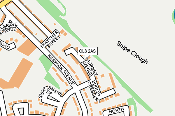
OL8 2AS is located in the Medlock Vale electoral ward, within the metropolitan district of Oldham and the English Parliamentary constituency of Oldham West and Royton. The Sub Integrated Care Board (ICB) Location is NHS Greater Manchester ICB - 00Y and the police force is Greater Manchester. This postcode has been in use since September 2014.


GetTheData
Source: OS OpenMap – Local (Ordnance Survey)
Source: OS VectorMap District (Ordnance Survey)
Licence: Open Government Licence (requires attribution)
| Easting | 393428 |
| Northing | 403450 |
| Latitude | 53.527669 |
| Longitude | -2.100608 |
GetTheData
Source: Open Postcode Geo
Licence: Open Government Licence
| Country | England |
| Postcode District | OL8 |
| ➜ OL8 open data dashboard ➜ See where OL8 is on a map ➜ Where is Oldham? | |
GetTheData
Source: Land Registry Price Paid Data
Licence: Open Government Licence
Elevation or altitude of OL8 2AS as distance above sea level:
| Metres | Feet | |
|---|---|---|
| Elevation | 170m | 558ft |
Elevation is measured from the approximate centre of the postcode, to the nearest point on an OS contour line from OS Terrain 50, which has contour spacing of ten vertical metres.
➜ How high above sea level am I? Find the elevation of your current position using your device's GPS.
GetTheData
Source: Open Postcode Elevation
Licence: Open Government Licence
| Ward | Medlock Vale |
| Constituency | Oldham West And Royton |
GetTheData
Source: ONS Postcode Database
Licence: Open Government Licence
| June 2021 | Violence and sexual offences | On or near Sportsmans Drive | 178m |
| ➜ Get more crime data in our Crime section | |||
GetTheData
Source: data.police.uk
Licence: Open Government Licence
| Keswick Ave/Sportsman Dr (Keswick Ave) | Hathershaw | 100m |
| Keswick Ave/Sportsman Dr (Keswick Ave) | Hathershaw | 140m |
| Keswick Ave/Belgrave Ave (Keswick Ave) | Hathershaw | 283m |
| Keswick Ave/The Green (Keswick Ave) | Hathershaw | 304m |
| Honeywell Ln/Meldrum St (Honeywell Ln) | Hathershaw | 369m |
| Oldham Central (Manchester Metrolink) (Union St) | Oldham | 1,597m |
| Oldham King Street (Manchester Metrolink) (King St) | Oldham | 1,719m |
| Ashton-under-Lyne Station | 4.1km |
| Mossley (Manchester) Station | 4.2km |
| Moston Station | 4.7km |
GetTheData
Source: NaPTAN
Licence: Open Government Licence
| Percentage of properties with Next Generation Access | 100.0% |
| Percentage of properties with Superfast Broadband | 100.0% |
| Percentage of properties with Ultrafast Broadband | 0.0% |
| Percentage of properties with Full Fibre Broadband | 0.0% |
Superfast Broadband is between 30Mbps and 300Mbps
Ultrafast Broadband is > 300Mbps
| Percentage of properties unable to receive 2Mbps | 0.0% |
| Percentage of properties unable to receive 5Mbps | 0.0% |
| Percentage of properties unable to receive 10Mbps | 0.0% |
| Percentage of properties unable to receive 30Mbps | 0.0% |
GetTheData
Source: Ofcom
Licence: Ofcom Terms of Use (requires attribution)
GetTheData
Source: ONS Postcode Database
Licence: Open Government Licence


➜ Get more ratings from the Food Standards Agency
GetTheData
Source: Food Standards Agency
Licence: FSA terms & conditions
| Last Collection | |||
|---|---|---|---|
| Location | Mon-Fri | Sat | Distance |
| Marland Fold | 17:05 | 11:30 | 1,255m |
| 1 Chatsworth Street | 17:20 | 12:10 | 1,547m |
| Oldham Delivery Office | 19:00 | 1,566m | |
GetTheData
Source: Dracos
Licence: Creative Commons Attribution-ShareAlike
| Facility | Distance |
|---|---|
| Snipe Clough Ashville Court, Oldham Grass Pitches | 180m |
| Tate Street Tate Street, Oldham Grass Pitches | 498m |
| Glodwick Cricket Club Warren Lane, Oldham Grass Pitches | 510m |
GetTheData
Source: Active Places
Licence: Open Government Licence
| School | Phase of Education | Distance |
|---|---|---|
| Alexandra Park Junior School Brook Lane, Oldham, OL8 2BE | Primary | 530m |
| Alexandra Park Junior School Brook Lane, Oldham, OL8 2BE | Primary | 530m |
| Medlock Valley Primary School Deanshut Road, Fitton Hill, Oldham, OL8 2PN | Primary | 567m |
GetTheData
Source: Edubase
Licence: Open Government Licence
The below table lists the International Territorial Level (ITL) codes (formerly Nomenclature of Territorial Units for Statistics (NUTS) codes) and Local Administrative Units (LAU) codes for OL8 2AS:
| ITL 1 Code | Name |
|---|---|
| TLD | North West (England) |
| ITL 2 Code | Name |
| TLD3 | Greater Manchester |
| ITL 3 Code | Name |
| TLD37 | Greater Manchester North East |
| LAU 1 Code | Name |
| E08000004 | Oldham |
GetTheData
Source: ONS Postcode Directory
Licence: Open Government Licence
The below table lists the Census Output Area (OA), Lower Layer Super Output Area (LSOA), and Middle Layer Super Output Area (MSOA) for OL8 2AS:
| Code | Name | |
|---|---|---|
| OA | E00026956 | |
| LSOA | E01005325 | Oldham 029D |
| MSOA | E02001126 | Oldham 029 |
GetTheData
Source: ONS Postcode Directory
Licence: Open Government Licence
| OL8 2LD | Keswick Avenue | 69m |
| OL8 2JX | Thatcher Street | 131m |
| OL8 2LF | Keswick Avenue | 190m |
| OL8 2JT | Belgrave Road | 231m |
| OL8 2JU | Belgrave Road | 234m |
| OL8 2JZ | Keswick Avenue | 242m |
| OL8 2LG | North Croft | 251m |
| OL8 2JY | Keswick Avenue | 261m |
| OL8 2LB | Fitton Hill Road | 266m |
| OL8 2LP | Dowry Street | 269m |
GetTheData
Source: Open Postcode Geo; Land Registry Price Paid Data
Licence: Open Government Licence