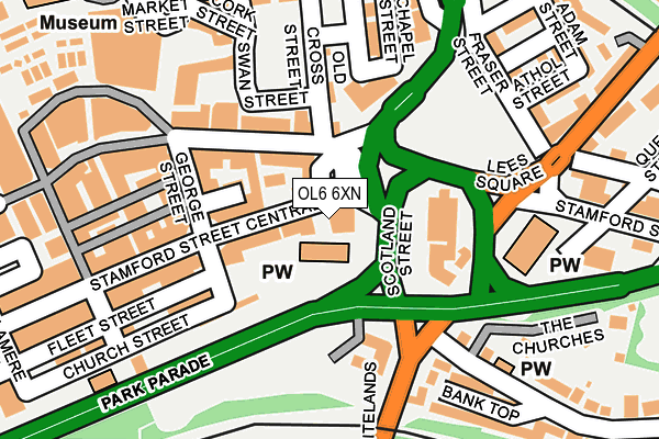
OL6 6XN is located in the St Peter's electoral ward, within the metropolitan district of Tameside and the English Parliamentary constituency of Ashton-under-Lyne. The Sub Integrated Care Board (ICB) Location is NHS Greater Manchester ICB - 01Y and the police force is Greater Manchester. This postcode has been in use since January 1992.


GetTheData
Source: OS OpenMap – Local (Ordnance Survey)
Source: OS VectorMap District (Ordnance Survey)
Licence: Open Government Licence (requires attribution)
| Easting | 394146 |
| Northing | 399026 |
| Latitude | 53.487913 |
| Longitude | -2.089693 |
GetTheData
Source: Open Postcode Geo
Licence: Open Government Licence
| Country | England |
| Postcode District | OL6 |
| ➜ OL6 open data dashboard ➜ See where OL6 is on a map ➜ Where is Ashton-under-Lyne? | |
GetTheData
Source: Land Registry Price Paid Data
Licence: Open Government Licence
Elevation or altitude of OL6 6XN as distance above sea level:
| Metres | Feet | |
|---|---|---|
| Elevation | 110m | 361ft |
Elevation is measured from the approximate centre of the postcode, to the nearest point on an OS contour line from OS Terrain 50, which has contour spacing of ten vertical metres.
➜ How high above sea level am I? Find the elevation of your current position using your device's GPS.
GetTheData
Source: Open Postcode Elevation
Licence: Open Government Licence
| Ward | St Peter's |
| Constituency | Ashton-under-lyne |
GetTheData
Source: ONS Postcode Database
Licence: Open Government Licence
| April 2021 | Violence and sexual offences | On or near Grafton Street | 413m |
| ➜ Get more crime data in our Crime section | |||
GetTheData
Source: data.police.uk
Licence: Open Government Licence
| Stamford St/Old Square (Stamford St) | Ashton Under Lyne | 61m |
| Old Cross St/Mulberry St (Old Cross St) | Ashton Under Lyne | 131m |
| Arlington Way/Penny Meadow (Arlington Way) | Ashton Under Lyne | 203m |
| Penny Meadow/Swan St (Penny Meadow) | Ashton Under Lyne | 220m |
| Penny Meadow/Glebe St (Penny Meadow) | Ashton Under Lyne | 224m |
| Ashton-under-lyne (Manchester Metrolink) (Wellington Rd) | Ashton Under Lyne | 615m |
| Ashton West (Manchester Metrolink) (Lord Sheldon Way) | Ashton Moss | 1,354m |
| Ashton-under-Lyne Station | 0.5km |
| Stalybridge Station | 1.8km |
| Guide Bridge Station | 2.2km |
GetTheData
Source: NaPTAN
Licence: Open Government Licence
GetTheData
Source: ONS Postcode Database
Licence: Open Government Licence


➜ Get more ratings from the Food Standards Agency
GetTheData
Source: Food Standards Agency
Licence: FSA terms & conditions
| Last Collection | |||
|---|---|---|---|
| Location | Mon-Fri | Sat | Distance |
| Grafton Street | 17:30 | 11:25 | 435m |
| Ashton Delivery Office | 19:00 | 542m | |
| Crescent Road | 17:30 | 11:40 | 861m |
GetTheData
Source: Dracos
Licence: Creative Commons Attribution-ShareAlike
| Facility | Distance |
|---|---|
| Crossfit Tameside (Closed) Lower Wharf Street, Ashton-under-lyne Sports Hall | 238m |
| Total Body Fitness Centre (Closed) Henrietta Street, Ashton-under-lyne Health and Fitness Gym | 462m |
| International Gym & Hope Street Boxing Lord Street, Ashton-under-lyne Health and Fitness Gym | 534m |
GetTheData
Source: Active Places
Licence: Open Government Licence
| School | Phase of Education | Distance |
|---|---|---|
| Parochial CofE Primary and Nursery School, Ashton-under-Lyne Keppel Street, Ashton-under-Lyne, OL6 6NN | Primary | 382m |
| St James' Church of England Primary School Romney Street, Ashton-under-Lyne, OL6 9HU | Primary | 395m |
| The Heys Primary School Whiteacre Road, Ashton-under-Lyne, OL6 9NS | Primary | 432m |
GetTheData
Source: Edubase
Licence: Open Government Licence
The below table lists the International Territorial Level (ITL) codes (formerly Nomenclature of Territorial Units for Statistics (NUTS) codes) and Local Administrative Units (LAU) codes for OL6 6XN:
| ITL 1 Code | Name |
|---|---|
| TLD | North West (England) |
| ITL 2 Code | Name |
| TLD3 | Greater Manchester |
| ITL 3 Code | Name |
| TLD35 | Greater Manchester South East |
| LAU 1 Code | Name |
| E08000008 | Tameside |
GetTheData
Source: ONS Postcode Directory
Licence: Open Government Licence
The below table lists the Census Output Area (OA), Lower Layer Super Output Area (LSOA), and Middle Layer Super Output Area (MSOA) for OL6 6XN:
| Code | Name | |
|---|---|---|
| OA | E00030151 | |
| LSOA | E01005948 | Tameside 013A |
| MSOA | E02001241 | Tameside 013 |
GetTheData
Source: ONS Postcode Directory
Licence: Open Government Licence
| OL6 6LE | St Michaels Square | 38m |
| OL6 6XJ | Stamford Street Central | 44m |
| OL6 6JY | Stamford Arcade | 79m |
| OL6 6LA | Old Street | 93m |
| OL6 6LB | Old Street | 111m |
| OL6 6AD | Stamford Street Central | 128m |
| OL6 6AQ | George Street | 141m |
| OL6 6XE | Church Street | 148m |
| OL6 6HD | Glebe Street | 165m |
| OL6 6BX | Market Street | 176m |
GetTheData
Source: Open Postcode Geo; Land Registry Price Paid Data
Licence: Open Government Licence