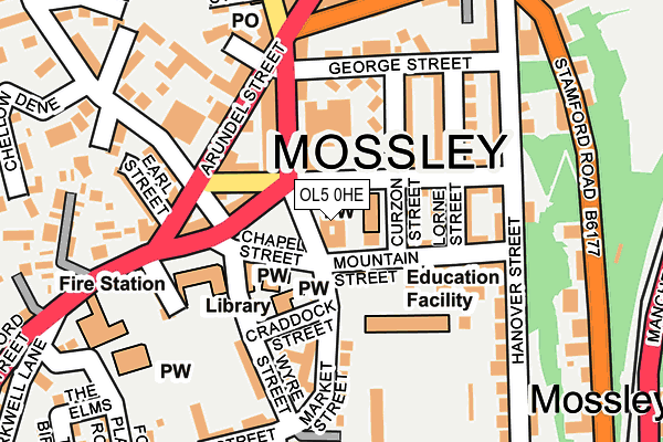
OL5 0HE lies on Market Place in Mossley, Ashton-under-lyne. OL5 0HE is located in the Mossley electoral ward, within the metropolitan district of Tameside and the English Parliamentary constituency of Stalybridge and Hyde. The Sub Integrated Care Board (ICB) Location is NHS Greater Manchester ICB - 01Y and the police force is Greater Manchester. This postcode has been in use since January 1980.


GetTheData
Source: OS OpenMap – Local (Ordnance Survey)
Source: OS VectorMap District (Ordnance Survey)
Licence: Open Government Licence (requires attribution)
| Easting | 397071 |
| Northing | 402355 |
| Latitude | 53.517861 |
| Longitude | -2.045643 |
GetTheData
Source: Open Postcode Geo
Licence: Open Government Licence
| Street | Market Place |
| Locality | Mossley |
| Town/City | Ashton-under-lyne |
| Country | England |
| Postcode District | OL5 |
| ➜ OL5 open data dashboard ➜ See where OL5 is on a map ➜ Where is Mossley? | |
GetTheData
Source: Land Registry Price Paid Data
Licence: Open Government Licence
Elevation or altitude of OL5 0HE as distance above sea level:
| Metres | Feet | |
|---|---|---|
| Elevation | 210m | 689ft |
Elevation is measured from the approximate centre of the postcode, to the nearest point on an OS contour line from OS Terrain 50, which has contour spacing of ten vertical metres.
➜ How high above sea level am I? Find the elevation of your current position using your device's GPS.
GetTheData
Source: Open Postcode Elevation
Licence: Open Government Licence
| Ward | Mossley |
| Constituency | Stalybridge And Hyde |
GetTheData
Source: ONS Postcode Database
Licence: Open Government Licence
| May 2021 | Violence and sexual offences | On or near Seel Street | 216m |
| ➜ Get more crime data in our Crime section | |||
GetTheData
Source: data.police.uk
Licence: Open Government Licence
| Stamford St/Market Place (Stamford St) | Top Mossley | 64m |
| Stamford St/Market Place (Stamford St) | Brookbottom | 75m |
| Arundel St/Dean St (Arundel St) | Brookbottom | 133m |
| Waterton Lane (Nth Bnd) (Waterton Lane) | Brookbottom | 141m |
| Stamford St/St. George's Sch (Stamford St) | Brookbottom | 230m |
| Mossley (Manchester) Station | 0.4km |
| Greenfield Station | 3.1km |
| Stalybridge Station | 3.9km |
GetTheData
Source: NaPTAN
Licence: Open Government Licence
GetTheData
Source: ONS Postcode Database
Licence: Open Government Licence


➜ Get more ratings from the Food Standards Agency
GetTheData
Source: Food Standards Agency
Licence: FSA terms & conditions
| Last Collection | |||
|---|---|---|---|
| Location | Mon-Fri | Sat | Distance |
| Upper Mosley P.o. | 17:15 | 11:35 | 273m |
| Mossley P.o. | 17:30 | 11:30 | 509m |
| Heyhead | 16:30 | 11:30 | 1,477m |
GetTheData
Source: Dracos
Licence: Creative Commons Attribution-ShareAlike
| Facility | Distance |
|---|---|
| Seel Park Market Street, Mossley, Ashton-under-lyne Grass Pitches | 225m |
| Mossley Park Stamford Road, Mossley, Ashton-under-lyne Grass Pitches | 317m |
| King Georges Field (Mossley) Egmont Street, Mossley Grass Pitches | 905m |
GetTheData
Source: Active Places
Licence: Open Government Licence
| School | Phase of Education | Distance |
|---|---|---|
| St Joseph's RC Primary School Market Street, Mossley, Ashton-under-Lyne, OL5 0ES | Primary | 114m |
| St George's CofE Primary School Stamford Street, Mossley, Ashton-Under-Lyne, OL5 0HT | Primary | 234m |
| Livingstone Primary School Valeside, Mossley, Ashton-under-Lyne, OL5 0AP | Primary | 424m |
GetTheData
Source: Edubase
Licence: Open Government Licence
The below table lists the International Territorial Level (ITL) codes (formerly Nomenclature of Territorial Units for Statistics (NUTS) codes) and Local Administrative Units (LAU) codes for OL5 0HE:
| ITL 1 Code | Name |
|---|---|
| TLD | North West (England) |
| ITL 2 Code | Name |
| TLD3 | Greater Manchester |
| ITL 3 Code | Name |
| TLD35 | Greater Manchester South East |
| LAU 1 Code | Name |
| E08000008 | Tameside |
GetTheData
Source: ONS Postcode Directory
Licence: Open Government Licence
The below table lists the Census Output Area (OA), Lower Layer Super Output Area (LSOA), and Middle Layer Super Output Area (MSOA) for OL5 0HE:
| Code | Name | |
|---|---|---|
| OA | E00030675 | |
| LSOA | E01006058 | Tameside 001E |
| MSOA | E02001229 | Tameside 001 |
GetTheData
Source: ONS Postcode Directory
Licence: Open Government Licence
| OL5 0HF | Argyle Street | 26m |
| OL5 0ET | Market Street | 69m |
| OL5 0HB | Curzon Street | 69m |
| OL5 0EX | Chapel Street | 80m |
| OL5 0EY | Mountain Street | 86m |
| OL5 0HD | Curzon Street | 91m |
| OL5 0PD | Lancaster Street | 96m |
| OL5 0LN | Stamford Street | 99m |
| OL5 0HH | Lorne Street | 102m |
| OL5 0HG | Argyle Street | 104m |
GetTheData
Source: Open Postcode Geo; Land Registry Price Paid Data
Licence: Open Government Licence