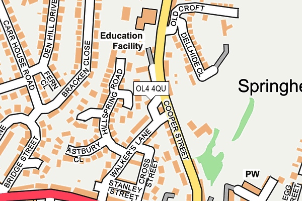
OL4 4QU lies on Walkers in Springhead, Oldham. OL4 4QU is located in the Saddleworth West & Lees electoral ward, within the metropolitan district of Oldham and the English Parliamentary constituency of Oldham East and Saddleworth. The Sub Integrated Care Board (ICB) Location is NHS Greater Manchester ICB - 00Y and the police force is Greater Manchester. This postcode has been in use since January 1980.


GetTheData
Source: OS OpenMap – Local (Ordnance Survey)
Source: OS VectorMap District (Ordnance Survey)
Licence: Open Government Licence (requires attribution)
| Easting | 396107 |
| Northing | 404774 |
| Latitude | 53.539614 |
| Longitude | -2.060210 |
GetTheData
Source: Open Postcode Geo
Licence: Open Government Licence
| Street | Walkers |
| Locality | Springhead |
| Town/City | Oldham |
| Country | England |
| Postcode District | OL4 |
| ➜ OL4 open data dashboard ➜ See where OL4 is on a map ➜ Where is Lees? | |
GetTheData
Source: Land Registry Price Paid Data
Licence: Open Government Licence
Elevation or altitude of OL4 4QU as distance above sea level:
| Metres | Feet | |
|---|---|---|
| Elevation | 220m | 722ft |
Elevation is measured from the approximate centre of the postcode, to the nearest point on an OS contour line from OS Terrain 50, which has contour spacing of ten vertical metres.
➜ How high above sea level am I? Find the elevation of your current position using your device's GPS.
GetTheData
Source: Open Postcode Elevation
Licence: Open Government Licence
| Ward | Saddleworth West & Lees |
| Constituency | Oldham East And Saddleworth |
GetTheData
Source: ONS Postcode Database
Licence: Open Government Licence
| Oldham Rd/Walkers Ln (Oldham Rd) | Springhead | 223m |
| Cooper Street (Nbd) (Cooper Street) | Springhead | 224m |
| Oldham Rd/Cooper St (Oldham Rd) | Springhead | 278m |
| Oldham Rd/Springhead P.o. (Oldham Road) | Springhead | 289m |
| Oldham Rd/Springhead P.o. (Oldham Rd) | Springhead | 303m |
| Mossley (Manchester) Station | 3km |
| Greenfield Station | 3.1km |
GetTheData
Source: NaPTAN
Licence: Open Government Licence
| Percentage of properties with Next Generation Access | 100.0% |
| Percentage of properties with Superfast Broadband | 100.0% |
| Percentage of properties with Ultrafast Broadband | 0.0% |
| Percentage of properties with Full Fibre Broadband | 0.0% |
Superfast Broadband is between 30Mbps and 300Mbps
Ultrafast Broadband is > 300Mbps
| Percentage of properties unable to receive 2Mbps | 0.0% |
| Percentage of properties unable to receive 5Mbps | 0.0% |
| Percentage of properties unable to receive 10Mbps | 0.0% |
| Percentage of properties unable to receive 30Mbps | 0.0% |
GetTheData
Source: Ofcom
Licence: Ofcom Terms of Use (requires attribution)
GetTheData
Source: ONS Postcode Database
Licence: Open Government Licence


➜ Get more ratings from the Food Standards Agency
GetTheData
Source: Food Standards Agency
Licence: FSA terms & conditions
| Last Collection | |||
|---|---|---|---|
| Location | Mon-Fri | Sat | Distance |
| Lees P.o. | 18:00 | 11:55 | 493m |
| Cooper Street | 16:55 | 11:20 | 543m |
| Burnley Street | 17:45 | 11:10 | 1,975m |
GetTheData
Source: Dracos
Licence: Creative Commons Attribution-ShareAlike
| Facility | Distance |
|---|---|
| Ashfield Crescent Playing Fields Ashfield Crescent, Springhead, Oldham Grass Pitches | 478m |
| Viking Fitness St. Johns Industrial Estate, Lees, Oldham Health and Fitness Gym, Studio | 751m |
| Mills Recreation Ground Barn Fold, Lees, Oldham Grass Pitches | 809m |
GetTheData
Source: Active Places
Licence: Open Government Licence
| School | Phase of Education | Distance |
|---|---|---|
| Springhead Infant and Nursery School Cooper Street, Springhead, Oldham, OL4 4QT | Primary | 169m |
| Knowsley Junior School Stoneleigh Road, Springhead, Oldham, OL4 4BH | Primary | 511m |
| St Edwards Roman Catholic Primary, a Voluntary Academy Rowland Way, Lees, Oldham, OL4 3LQ | Primary | 808m |
GetTheData
Source: Edubase
Licence: Open Government Licence
The below table lists the International Territorial Level (ITL) codes (formerly Nomenclature of Territorial Units for Statistics (NUTS) codes) and Local Administrative Units (LAU) codes for OL4 4QU:
| ITL 1 Code | Name |
|---|---|
| TLD | North West (England) |
| ITL 2 Code | Name |
| TLD3 | Greater Manchester |
| ITL 3 Code | Name |
| TLD37 | Greater Manchester North East |
| LAU 1 Code | Name |
| E08000004 | Oldham |
GetTheData
Source: ONS Postcode Directory
Licence: Open Government Licence
The below table lists the Census Output Area (OA), Lower Layer Super Output Area (LSOA), and Middle Layer Super Output Area (MSOA) for OL4 4QU:
| Code | Name | |
|---|---|---|
| OA | E00027444 | |
| LSOA | E01005420 | Oldham 021D |
| MSOA | E02001118 | Oldham 021 |
GetTheData
Source: ONS Postcode Directory
Licence: Open Government Licence
| OL4 4SQ | Helsby Close | 26m |
| OL4 4QX | Walkers Court | 40m |
| OL4 4QD | Walkers Lane | 52m |
| OL4 4QT | Cooper Street | 74m |
| OL4 4SJ | Hillspring Road | 93m |
| OL4 4QE | Gordon Street | 109m |
| OL4 4QG | Livingstone Street | 126m |
| OL4 4PJ | Dellhide Close | 141m |
| OL4 4SP | Beechfield Close | 144m |
| OL4 4QS | Cooper Street | 158m |
GetTheData
Source: Open Postcode Geo; Land Registry Price Paid Data
Licence: Open Government Licence