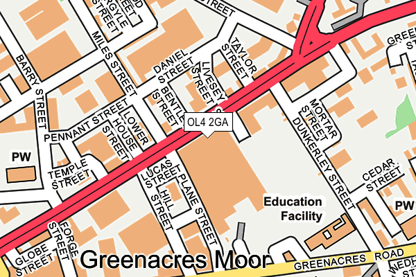
OL4 2GA is located in the Waterhead electoral ward, within the metropolitan district of Oldham and the English Parliamentary constituency of Oldham East and Saddleworth. The Sub Integrated Care Board (ICB) Location is NHS Greater Manchester ICB - 00Y and the police force is Greater Manchester. This postcode has been in use since April 2009.


GetTheData
Source: OS OpenMap – Local (Ordnance Survey)
Source: OS VectorMap District (Ordnance Survey)
Licence: Open Government Licence (requires attribution)
| Easting | 394044 |
| Northing | 405511 |
| Latitude | 53.546202 |
| Longitude | -2.091356 |
GetTheData
Source: Open Postcode Geo
Licence: Open Government Licence
| Country | England |
| Postcode District | OL4 |
| ➜ OL4 open data dashboard ➜ See where OL4 is on a map ➜ Where is Oldham? | |
GetTheData
Source: Land Registry Price Paid Data
Licence: Open Government Licence
Elevation or altitude of OL4 2GA as distance above sea level:
| Metres | Feet | |
|---|---|---|
| Elevation | 200m | 656ft |
Elevation is measured from the approximate centre of the postcode, to the nearest point on an OS contour line from OS Terrain 50, which has contour spacing of ten vertical metres.
➜ How high above sea level am I? Find the elevation of your current position using your device's GPS.
GetTheData
Source: Open Postcode Elevation
Licence: Open Government Licence
| Ward | Waterhead |
| Constituency | Oldham East And Saddleworth |
GetTheData
Source: ONS Postcode Database
Licence: Open Government Licence
| September 2021 | Violence and sexual offences | On or near Watson Street | 404m |
| ➜ Get more crime data in our Crime section | |||
GetTheData
Source: data.police.uk
Licence: Open Government Licence
| Huddersfield Rd/Tesco Store (Huddersfield Rd) | Greenacres | 28m |
| Huddersfield Rd/Hill Stores (Huddersfield Rd) | Greenacres | 74m |
| Huddersfield Rd/Hill St (Huddersfield Rd) | Greenacres | 81m |
| Dunkerley Street (Southbound) (Dunkerley St) | Greenacres | 131m |
| Huddersfield Rd/Hill St (Huddersfield Rd) | Greenacres | 135m |
| Derker (Manchester Metrolink) (Yates Street) | Derker | 790m |
| Oldham Mumps (Manchester Metrolink) (Mumps) | Oldham Mumps | 906m |
| Oldham Central (Manchester Metrolink) (Union St) | Oldham | 1,530m |
| Mossley (Manchester) Station | 4.8km |
GetTheData
Source: NaPTAN
Licence: Open Government Licence
GetTheData
Source: ONS Postcode Database
Licence: Open Government Licence


➜ Get more ratings from the Food Standards Agency
GetTheData
Source: Food Standards Agency
Licence: FSA terms & conditions
| Last Collection | |||
|---|---|---|---|
| Location | Mon-Fri | Sat | Distance |
| Burnley Street | 17:45 | 11:10 | 256m |
| 50 Spring Street | 17:40 | 12:15 | 261m |
| John Street | 16:45 | 11:20 | 262m |
GetTheData
Source: Dracos
Licence: Creative Commons Attribution-ShareAlike
| Facility | Distance |
|---|---|
| Rhinos Gym Ripponden Road, Oldham Health and Fitness Gym | 256m |
| Total Fitness (Oldham) (Closed) Cromford Street, Oldham Studio, Health and Fitness Gym | 696m |
| Woodlands Primary Academy Broadbent Road, Oldham Grass Pitches | 943m |
GetTheData
Source: Active Places
Licence: Open Government Licence
| School | Phase of Education | Distance |
|---|---|---|
| Greenacres Primary Academy Dunkerley Street, Oldham, OL4 2AX | Primary | 217m |
| St Anne's RC Primary School Greenacres Road, Oldham, OL4 1HP | Primary | 267m |
| Littlemoor Primary School Littlemoor Lane, Oldham, OL4 2RR | Primary | 512m |
GetTheData
Source: Edubase
Licence: Open Government Licence
The below table lists the International Territorial Level (ITL) codes (formerly Nomenclature of Territorial Units for Statistics (NUTS) codes) and Local Administrative Units (LAU) codes for OL4 2GA:
| ITL 1 Code | Name |
|---|---|
| TLD | North West (England) |
| ITL 2 Code | Name |
| TLD3 | Greater Manchester |
| ITL 3 Code | Name |
| TLD37 | Greater Manchester North East |
| LAU 1 Code | Name |
| E08000004 | Oldham |
GetTheData
Source: ONS Postcode Directory
Licence: Open Government Licence
The below table lists the Census Output Area (OA), Lower Layer Super Output Area (LSOA), and Middle Layer Super Output Area (MSOA) for OL4 2GA:
| Code | Name | |
|---|---|---|
| OA | E00027609 | |
| LSOA | E01005448 | Oldham 012A |
| MSOA | E02001109 | Oldham 012 |
GetTheData
Source: ONS Postcode Directory
Licence: Open Government Licence
| OL1 3PA | Huddersfield Road | 108m |
| OL1 3NQ | Huddersfield Road | 157m |
| OL1 3NR | Miles Street | 158m |
| OL4 2BX | Plane Street | 164m |
| OL1 4EN | Ripponden Road | 170m |
| OL1 3PH | Bower Street | 176m |
| OL4 2RD | Huddersfield Road | 177m |
| OL4 2DB | Greenwood Street | 206m |
| OL1 3PJ | Miles Street | 230m |
| OL1 4EW | Ripponden Road | 266m |
GetTheData
Source: Open Postcode Geo; Land Registry Price Paid Data
Licence: Open Government Licence