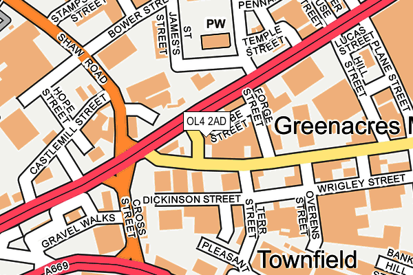
OL4 2AD is located in the St Mary's electoral ward, within the metropolitan district of Oldham and the English Parliamentary constituency of Oldham East and Saddleworth. The Sub Integrated Care Board (ICB) Location is NHS Greater Manchester ICB - 00Y and the police force is Greater Manchester. This postcode has been in use since January 1980.


GetTheData
Source: OS OpenMap – Local (Ordnance Survey)
Source: OS VectorMap District (Ordnance Survey)
Licence: Open Government Licence (requires attribution)
| Easting | 393761 |
| Northing | 405319 |
| Latitude | 53.544472 |
| Longitude | -2.095623 |
GetTheData
Source: Open Postcode Geo
Licence: Open Government Licence
| Country | England |
| Postcode District | OL4 |
| ➜ OL4 open data dashboard ➜ See where OL4 is on a map ➜ Where is Oldham? | |
GetTheData
Source: Land Registry Price Paid Data
Licence: Open Government Licence
Elevation or altitude of OL4 2AD as distance above sea level:
| Metres | Feet | |
|---|---|---|
| Elevation | 190m | 623ft |
Elevation is measured from the approximate centre of the postcode, to the nearest point on an OS contour line from OS Terrain 50, which has contour spacing of ten vertical metres.
➜ How high above sea level am I? Find the elevation of your current position using your device's GPS.
GetTheData
Source: Open Postcode Elevation
Licence: Open Government Licence
| Ward | St Mary's |
| Constituency | Oldham East And Saddleworth |
GetTheData
Source: ONS Postcode Database
Licence: Open Government Licence
| Huddersfield Rd/Greenacres Rd (Huddersfield Rd) | Greenacres | 27m |
| Greenacres Rd/Huddersfield Rd (Greenacres Rd) | Greenacres | 66m |
| Huddersfield Rd/Barry St (Huddersfield Rd) | Greenacres | 66m |
| Shaw Rd/Huddersfield Rd (Shaw Rd) | Lower Moor | 119m |
| Barry St/Huddersfield Rd (Barry St) | Derker | 145m |
| Oldham Mumps (Manchester Metrolink) (Mumps) | Oldham Mumps | 567m |
| Derker (Manchester Metrolink) (Yates Street) | Derker | 714m |
| Oldham Central (Manchester Metrolink) (Union St) | Oldham | 1,193m |
| Oldham King Street (Manchester Metrolink) (King St) | Oldham | 1,530m |
| Mossley (Manchester) Station | 4.9km |
GetTheData
Source: NaPTAN
Licence: Open Government Licence
GetTheData
Source: ONS Postcode Database
Licence: Open Government Licence


➜ Get more ratings from the Food Standards Agency
GetTheData
Source: Food Standards Agency
Licence: FSA terms & conditions
| Last Collection | |||
|---|---|---|---|
| Location | Mon-Fri | Sat | Distance |
| 1 Chatsworth Street | 17:20 | 12:10 | 386m |
| Oldham Delivery Office | 19:00 | 425m | |
| Burnley Street | 17:45 | 11:10 | 585m |
GetTheData
Source: Dracos
Licence: Creative Commons Attribution-ShareAlike
| Facility | Distance |
|---|---|
| Rhinos Gym Ripponden Road, Oldham Health and Fitness Gym | 587m |
| Total Fitness (Oldham) (Closed) Cromford Street, Oldham Studio, Health and Fitness Gym | 626m |
| Glodwick Pool (Closed) Nugget Street, Oldham Swimming Pool, Health and Fitness Gym | 704m |
GetTheData
Source: Active Places
Licence: Open Government Licence
| School | Phase of Education | Distance |
|---|---|---|
| St Anne's RC Primary School Greenacres Road, Oldham, OL4 1HP | Primary | 444m |
| Greenacres Primary Academy Dunkerley Street, Oldham, OL4 2AX | Primary | 462m |
| Horton Mill Community Primary School Southlink, Glodwick, Oldham, OL4 1GL | Primary | 517m |
GetTheData
Source: Edubase
Licence: Open Government Licence
The below table lists the International Territorial Level (ITL) codes (formerly Nomenclature of Territorial Units for Statistics (NUTS) codes) and Local Administrative Units (LAU) codes for OL4 2AD:
| ITL 1 Code | Name |
|---|---|
| TLD | North West (England) |
| ITL 2 Code | Name |
| TLD3 | Greater Manchester |
| ITL 3 Code | Name |
| TLD37 | Greater Manchester North East |
| LAU 1 Code | Name |
| E08000004 | Oldham |
GetTheData
Source: ONS Postcode Directory
Licence: Open Government Licence
The below table lists the Census Output Area (OA), Lower Layer Super Output Area (LSOA), and Middle Layer Super Output Area (MSOA) for OL4 2AD:
| Code | Name | |
|---|---|---|
| OA | E00027487 | |
| LSOA | E01005428 | Oldham 019A |
| MSOA | E02001116 | Oldham 019 |
GetTheData
Source: ONS Postcode Directory
Licence: Open Government Licence
| OL4 2AE | Huddersfield Road | 32m |
| OL4 1HA | Greenacres Road | 76m |
| OL1 3LN | Castle Park Industrial Estate | 112m |
| OL1 3LQ | Shaw Road | 115m |
| OL4 1HH | Mount Pleasant Industrial Estate | 130m |
| OL4 1HG | Terrace Street | 149m |
| OL4 1HB | Greenacres Road | 164m |
| OL4 1LA | Overens Street | 174m |
| OL4 1JW | Lees Road | 195m |
| OL1 3NQ | Huddersfield Road | 197m |
GetTheData
Source: Open Postcode Geo; Land Registry Price Paid Data
Licence: Open Government Licence