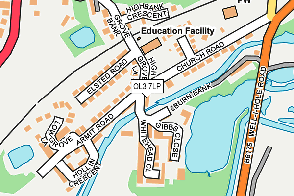
OL3 7LP lies on Park Cottages in Greenfield, Oldham. OL3 7LP is located in the Saddleworth South electoral ward, within the metropolitan district of Oldham and the English Parliamentary constituency of Oldham East and Saddleworth. The Sub Integrated Care Board (ICB) Location is NHS Greater Manchester ICB - 00Y and the police force is Greater Manchester. This postcode has been in use since January 1980.


GetTheData
Source: OS OpenMap – Local (Ordnance Survey)
Source: OS VectorMap District (Ordnance Survey)
Licence: Open Government Licence (requires attribution)
| Easting | 398335 |
| Northing | 404142 |
| Latitude | 53.533929 |
| Longitude | -2.026590 |
GetTheData
Source: Open Postcode Geo
Licence: Open Government Licence
| Street | Park Cottages |
| Locality | Greenfield |
| Town/City | Oldham |
| Country | England |
| Postcode District | OL3 |
➜ See where OL3 is on a map ➜ Where is Grasscroft? | |
GetTheData
Source: Land Registry Price Paid Data
Licence: Open Government Licence
Elevation or altitude of OL3 7LP as distance above sea level:
| Metres | Feet | |
|---|---|---|
| Elevation | 160m | 525ft |
Elevation is measured from the approximate centre of the postcode, to the nearest point on an OS contour line from OS Terrain 50, which has contour spacing of ten vertical metres.
➜ How high above sea level am I? Find the elevation of your current position using your device's GPS.
GetTheData
Source: Open Postcode Elevation
Licence: Open Government Licence
| Ward | Saddleworth South |
| Constituency | Oldham East And Saddleworth |
GetTheData
Source: ONS Postcode Database
Licence: Open Government Licence
| High Grove Road (Sth Bnd) (High Grove Road) | Friezland | 166m |
| Friezland Church (Wbnd) (Church Road) | Friezland | 220m |
| Mossley Rd/Clough Ln (Mossley Rd) | Grasscroft | 370m |
| Mossley Road | Grasscroft | 394m |
| Shaw Hall Bank Rd/Oaklands Rd (Shaw Hall Bank) | Friezland | 411m |
| Greenfield Station | 1km |
| Mossley (Manchester) Station | 2.3km |
| Ashton-under-Lyne Station | 6.5km |
GetTheData
Source: NaPTAN
Licence: Open Government Licence
| Percentage of properties with Next Generation Access | 100.0% |
| Percentage of properties with Superfast Broadband | 100.0% |
| Percentage of properties with Ultrafast Broadband | 100.0% |
| Percentage of properties with Full Fibre Broadband | 100.0% |
Superfast Broadband is between 30Mbps and 300Mbps
Ultrafast Broadband is > 300Mbps
| Percentage of properties unable to receive 2Mbps | 0.0% |
| Percentage of properties unable to receive 5Mbps | 0.0% |
| Percentage of properties unable to receive 10Mbps | 0.0% |
| Percentage of properties unable to receive 30Mbps | 0.0% |
GetTheData
Source: Ofcom
Licence: Ofcom Terms of Use (requires attribution)
GetTheData
Source: ONS Postcode Database
Licence: Open Government Licence


➜ Get more ratings from the Food Standards Agency
GetTheData
Source: Food Standards Agency
Licence: FSA terms & conditions
| Last Collection | |||
|---|---|---|---|
| Location | Mon-Fri | Sat | Distance |
| 60 Shaw Hall Bank Road | 17:45 | 12:00 | 661m |
| Greenfield P.o. | 17:30 | 11:45 | 1,357m |
| Clarence Hotel | 17:40 | 11:50 | 1,782m |
GetTheData
Source: Dracos
Licence: Creative Commons Attribution-ShareAlike
| Risk of OL3 7LP flooding from rivers and sea | High |
| ➜ OL3 7LP flood map | |
GetTheData
Source: Open Flood Risk by Postcode
Licence: Open Government Licence
The below table lists the International Territorial Level (ITL) codes (formerly Nomenclature of Territorial Units for Statistics (NUTS) codes) and Local Administrative Units (LAU) codes for OL3 7LP:
| ITL 1 Code | Name |
|---|---|
| TLD | North West (England) |
| ITL 2 Code | Name |
| TLD3 | Greater Manchester |
| ITL 3 Code | Name |
| TLD37 | Greater Manchester North East |
| LAU 1 Code | Name |
| E08000004 | Oldham |
GetTheData
Source: ONS Postcode Directory
Licence: Open Government Licence
The below table lists the Census Output Area (OA), Lower Layer Super Output Area (LSOA), and Middle Layer Super Output Area (MSOA) for OL3 7LP:
| Code | Name | |
|---|---|---|
| OA | E00027389 | |
| LSOA | E01005407 | Oldham 013A |
| MSOA | E02001110 | Oldham 013 |
GetTheData
Source: ONS Postcode Directory
Licence: Open Government Licence
| OL3 7LJ | High Grove Road | 58m |
| OL3 7LR | Royal George | 59m |
| OL3 7LN | Armit Road | 90m |
| OL3 7PN | Gibbs Close | 103m |
| OL3 7LL | Elsted Road | 111m |
| OL3 7LY | Church Meadow | 123m |
| OL3 7LQ | Church Road | 131m |
| OL3 7PP | Whitehead Close | 135m |
| OL4 4HS | Highbank Crescent | 185m |
| OL3 7LA | Low Grove Lane | 194m |
GetTheData
Source: Open Postcode Geo; Land Registry Price Paid Data
Licence: Open Government Licence