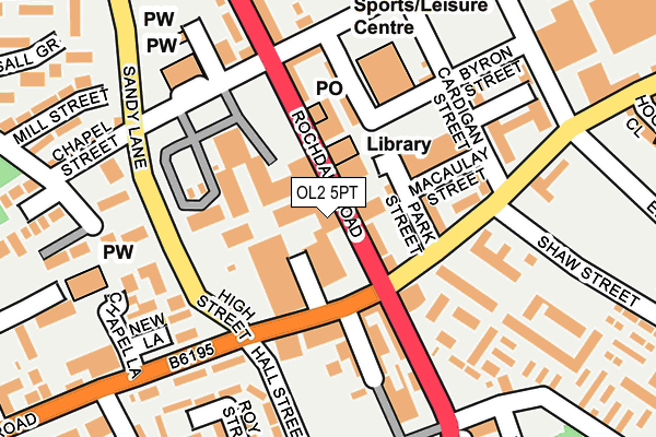
OL2 5PT is located in the Royton North electoral ward, within the metropolitan district of Oldham and the English Parliamentary constituency of Oldham West and Royton. The Sub Integrated Care Board (ICB) Location is NHS Greater Manchester ICB - 00Y and the police force is Greater Manchester. This postcode has been in use since January 1980.


GetTheData
Source: OS OpenMap – Local (Ordnance Survey)
Source: OS VectorMap District (Ordnance Survey)
Licence: Open Government Licence (requires attribution)
| Easting | 391980 |
| Northing | 407711 |
| Latitude | 53.565964 |
| Longitude | -2.122560 |
GetTheData
Source: Open Postcode Geo
Licence: Open Government Licence
| Country | England |
| Postcode District | OL2 |
| ➜ OL2 open data dashboard ➜ See where OL2 is on a map ➜ Where is Royton? | |
GetTheData
Source: Land Registry Price Paid Data
Licence: Open Government Licence
Elevation or altitude of OL2 5PT as distance above sea level:
| Metres | Feet | |
|---|---|---|
| Elevation | 160m | 525ft |
Elevation is measured from the approximate centre of the postcode, to the nearest point on an OS contour line from OS Terrain 50, which has contour spacing of ten vertical metres.
➜ How high above sea level am I? Find the elevation of your current position using your device's GPS.
GetTheData
Source: Open Postcode Elevation
Licence: Open Government Licence
| Ward | Royton North |
| Constituency | Oldham West And Royton |
GetTheData
Source: ONS Postcode Database
Licence: Open Government Licence
| May 2022 | Public order | On or near Roman Road | 330m |
| January 2022 | Violence and sexual offences | On or near Police Station | 197m |
| August 2021 | Violence and sexual offences | On or near Oldham Road | 347m |
| ➜ Get more crime data in our Crime section | |||
GetTheData
Source: data.police.uk
Licence: Open Government Licence
| Middleton Rd/High St (Middleton Rd) | Royton | 90m |
| Rochdale Rd/Royton Health Ctr (Rochdale Rd) | Royton | 97m |
| Middleton Rd/High St (Middleton Rd) | Royton | 100m |
| High Barn St/Park St (High Barn St) | Royton | 131m |
| High Barn St/Park St (High Barn St) | Royton | 144m |
| Mills Hill (Manchester) Station | 3.6km |
| Castleton (Manchester) Station | 4.7km |
| Rochdale Station | 5.3km |
GetTheData
Source: NaPTAN
Licence: Open Government Licence
GetTheData
Source: ONS Postcode Database
Licence: Open Government Licence


➜ Get more ratings from the Food Standards Agency
GetTheData
Source: Food Standards Agency
Licence: FSA terms & conditions
| Last Collection | |||
|---|---|---|---|
| Location | Mon-Fri | Sat | Distance |
| Haggate Old Post Office | 17:00 | 11:20 | 906m |
| Sheepfoot Lane | 17:30 | 11:15 | 1,297m |
| Woodland Park | 17:30 | 11:30 | 1,586m |
GetTheData
Source: Dracos
Licence: Creative Commons Attribution-ShareAlike
| Facility | Distance |
|---|---|
| Royton Sports Centre (Closed) Park Street, Royton, Oldham Sports Hall, Swimming Pool, Health and Fitness Gym | 113m |
| Royton Leisure Centre Byron Street, Royton, Oldham Health and Fitness Gym, Swimming Pool, Studio | 143m |
| Royton Park Bleasdale Street, Royton, Oldham Outdoor Tennis Courts | 324m |
GetTheData
Source: Active Places
Licence: Open Government Licence
| School | Phase of Education | Distance |
|---|---|---|
| Ss Aidan and Oswald's Roman Catholic Primary School Roman Road, Royton, Oldham, OL2 5PQ | Primary | 298m |
| Brookland School 13 Newhey Road, Milnrow, Rochdale, Royton, OL16 3NP | Not applicable | 300m |
| Royton Hall Primary School High Barn Street, Royton, Oldham, OL2 6RW | Primary | 526m |
GetTheData
Source: Edubase
Licence: Open Government Licence
The below table lists the International Territorial Level (ITL) codes (formerly Nomenclature of Territorial Units for Statistics (NUTS) codes) and Local Administrative Units (LAU) codes for OL2 5PT:
| ITL 1 Code | Name |
|---|---|
| TLD | North West (England) |
| ITL 2 Code | Name |
| TLD3 | Greater Manchester |
| ITL 3 Code | Name |
| TLD37 | Greater Manchester North East |
| LAU 1 Code | Name |
| E08000004 | Oldham |
GetTheData
Source: ONS Postcode Directory
Licence: Open Government Licence
The below table lists the Census Output Area (OA), Lower Layer Super Output Area (LSOA), and Middle Layer Super Output Area (MSOA) for OL2 5PT:
| Code | Name | |
|---|---|---|
| OA | E00027319 | |
| LSOA | E01005392 | Oldham 008B |
| MSOA | E02001105 | Oldham 008 |
GetTheData
Source: ONS Postcode Directory
Licence: Open Government Licence
| OL2 5QD | Market Square | 59m |
| OL2 6QJ | Rochdale Road | 60m |
| OL2 6QW | Park Street | 66m |
| OL2 5QA | Market Street | 89m |
| OL2 5PA | Middleton Road | 105m |
| OL2 6QN | Park Street | 113m |
| OL2 6QA | Spindle Court | 121m |
| OL2 5PE | Oldham Road | 133m |
| OL2 5PB | Shepherd Street | 141m |
| OL2 6QL | Radcliffe Street | 157m |
GetTheData
Source: Open Postcode Geo; Land Registry Price Paid Data
Licence: Open Government Licence