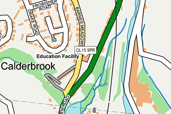
OL15 9PR is located in the Littleborough Lakeside electoral ward, within the metropolitan district of Rochdale and the English Parliamentary constituency of Rochdale. The Sub Integrated Care Board (ICB) Location is NHS Greater Manchester ICB - 01D and the police force is Greater Manchester. This postcode has been in use since January 1980.


GetTheData
Source: OS OpenMap – Local (Ordnance Survey)
Source: OS VectorMap District (Ordnance Survey)
Licence: Open Government Licence (requires attribution)
| Easting | 394504 |
| Northing | 417943 |
| Latitude | 53.657949 |
| Longitude | -2.084638 |
GetTheData
Source: Open Postcode Geo
Licence: Open Government Licence
| Country | England |
| Postcode District | OL15 |
| ➜ OL15 open data dashboard ➜ See where OL15 is on a map ➜ Where is Summit? | |
GetTheData
Source: Land Registry Price Paid Data
Licence: Open Government Licence
Elevation or altitude of OL15 9PR as distance above sea level:
| Metres | Feet | |
|---|---|---|
| Elevation | 170m | 558ft |
Elevation is measured from the approximate centre of the postcode, to the nearest point on an OS contour line from OS Terrain 50, which has contour spacing of ten vertical metres.
➜ How high above sea level am I? Find the elevation of your current position using your device's GPS.
GetTheData
Source: Open Postcode Elevation
Licence: Open Government Licence
| Ward | Littleborough Lakeside |
| Constituency | Rochdale |
GetTheData
Source: ONS Postcode Database
Licence: Open Government Licence
| Todmorden Rd/Stansfield Primary Sch (Todmorden Road) | Stansfield | 30m |
| Barnes Meadow/Calderbrook Terrace (Barnes Meadow) | Stansfield | 41m |
| Barnes Meadow/Calderbrook Terrace (Barnes Meadow) | Stansfield | 55m |
| Todmorden Rd/Stansfield Primary Sch (Todmorden Rd) | Stansfield | 107m |
| Barnes Meadow/Drake Rd (Barnes Meadow) | Stansfield | 181m |
| Littleborough Station | 1.8km |
| Smithy Bridge Station | 3.3km |
| Walsden Station | 4.5km |
GetTheData
Source: NaPTAN
Licence: Open Government Licence
GetTheData
Source: ONS Postcode Database
Licence: Open Government Licence


➜ Get more ratings from the Food Standards Agency
GetTheData
Source: Food Standards Agency
Licence: FSA terms & conditions
| Last Collection | |||
|---|---|---|---|
| Location | Mon-Fri | Sat | Distance |
| 6 Deanhead | 17:15 | 11:00 | 1,165m |
| Mount Avenue | 17:15 | 11:00 | 1,311m |
| Rake Inn | 17:25 | 11:00 | 1,385m |
GetTheData
Source: Dracos
Licence: Creative Commons Attribution-ShareAlike
| Facility | Distance |
|---|---|
| Stansfield Hall Ce Primary School Todmorden Road, Littleborough Grass Pitches | 0m |
| Littleborough Sports Centre Calderbrook Road, Littleborough Sports Hall, Health and Fitness Gym, Grass Pitches, Squash Courts, Artificial Grass Pitch | 1.3km |
| Littleborough Playing Fields Denhurst Road, Littleborough Grass Pitches | 1.3km |
GetTheData
Source: Active Places
Licence: Open Government Licence
| School | Phase of Education | Distance |
|---|---|---|
| Stansfield Hall Church of England / Methodist Church Primary School Todmorden Road, Summit, Littleborough, OL15 9PR | Primary | 11m |
| Littleborough Community Primary School Calderbrook Road, Littleborough, OL15 9HW | Primary | 1.3km |
| Holy Trinity Church of England Primary School Victoria Street, Littleborough, OL15 9DB | Primary | 1.6km |
GetTheData
Source: Edubase
Licence: Open Government Licence
The below table lists the International Territorial Level (ITL) codes (formerly Nomenclature of Territorial Units for Statistics (NUTS) codes) and Local Administrative Units (LAU) codes for OL15 9PR:
| ITL 1 Code | Name |
|---|---|
| TLD | North West (England) |
| ITL 2 Code | Name |
| TLD3 | Greater Manchester |
| ITL 3 Code | Name |
| TLD37 | Greater Manchester North East |
| LAU 1 Code | Name |
| E08000005 | Rochdale |
GetTheData
Source: ONS Postcode Directory
Licence: Open Government Licence
The below table lists the Census Output Area (OA), Lower Layer Super Output Area (LSOA), and Middle Layer Super Output Area (MSOA) for OL15 9PR:
| Code | Name | |
|---|---|---|
| OA | E00027920 | |
| LSOA | E01005520 | Rochdale 001B |
| MSOA | E02001132 | Rochdale 001 |
GetTheData
Source: ONS Postcode Directory
Licence: Open Government Licence
| OL15 9PW | Barnes Meadows | 72m |
| OL15 9PP | Calderbrook Terrace | 86m |
| OL15 9PS | Drake Road | 109m |
| OL15 9QJ | Rock Nook | 123m |
| OL15 9PN | Green Clough | 135m |
| OL15 9PT | Hawkins Way | 145m |
| OL15 9PX | Raleigh Gardens | 187m |
| OL15 9PU | Norfolk Close | 207m |
| OL15 9PY | Drake Road | 229m |
| OL15 9PH | Grove Cottages | 231m |
GetTheData
Source: Open Postcode Geo; Land Registry Price Paid Data
Licence: Open Government Licence