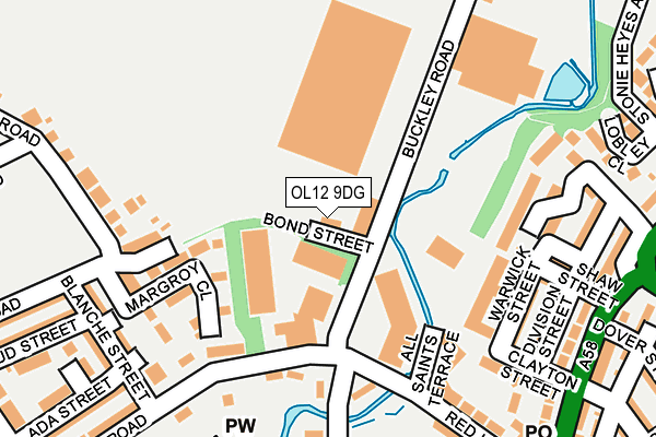
OL12 9DG lies on Bond Street in Rochdale. OL12 9DG is located in the Healey electoral ward, within the metropolitan district of Rochdale and the English Parliamentary constituency of Rochdale. The Sub Integrated Care Board (ICB) Location is NHS Greater Manchester ICB - 01D and the police force is Greater Manchester. This postcode has been in use since April 1985.


GetTheData
Source: OS OpenMap – Local (Ordnance Survey)
Source: OS VectorMap District (Ordnance Survey)
Licence: Open Government Licence (requires attribution)
| Easting | 390490 |
| Northing | 414752 |
| Latitude | 53.629225 |
| Longitude | -2.145275 |
GetTheData
Source: Open Postcode Geo
Licence: Open Government Licence
| Street | Bond Street |
| Town/City | Rochdale |
| Country | England |
| Postcode District | OL12 |
| ➜ OL12 open data dashboard ➜ See where OL12 is on a map ➜ Where is Rochdale? | |
GetTheData
Source: Land Registry Price Paid Data
Licence: Open Government Licence
Elevation or altitude of OL12 9DG as distance above sea level:
| Metres | Feet | |
|---|---|---|
| Elevation | 140m | 459ft |
Elevation is measured from the approximate centre of the postcode, to the nearest point on an OS contour line from OS Terrain 50, which has contour spacing of ten vertical metres.
➜ How high above sea level am I? Find the elevation of your current position using your device's GPS.
GetTheData
Source: Open Postcode Elevation
Licence: Open Government Licence
| Ward | Healey |
| Constituency | Rochdale |
GetTheData
Source: ONS Postcode Database
Licence: Open Government Licence
| Foxholes Rd (E Bnd) (Foxholes Rd) | Buckley | 161m |
| Red Lane (W Bnd) (Red Lane) | Buckley | 186m |
| Blanche Street (N Bnd) (Blanche Street) | Buckley | 231m |
| Blanche St (S Bnd) (Blanche St) | Buckley | 245m |
| Greenbank Rd (Sw Bnd) (Greenbank Road) | Buckley | 246m |
| Rochdale Interchange (Manchester Metrolink) (Smith Street) | Rochdale | 1,481m |
| Smithy Bridge Station | 2.1km |
| Rochdale Station | 2.2km |
| Littleborough Station | 3.7km |
GetTheData
Source: NaPTAN
Licence: Open Government Licence
| Percentage of properties with Next Generation Access | 100.0% |
| Percentage of properties with Superfast Broadband | 100.0% |
| Percentage of properties with Ultrafast Broadband | 75.0% |
| Percentage of properties with Full Fibre Broadband | 0.0% |
Superfast Broadband is between 30Mbps and 300Mbps
Ultrafast Broadband is > 300Mbps
| Percentage of properties unable to receive 2Mbps | 0.0% |
| Percentage of properties unable to receive 5Mbps | 0.0% |
| Percentage of properties unable to receive 10Mbps | 0.0% |
| Percentage of properties unable to receive 30Mbps | 0.0% |
GetTheData
Source: Ofcom
Licence: Ofcom Terms of Use (requires attribution)
GetTheData
Source: ONS Postcode Database
Licence: Open Government Licence


➜ Get more ratings from the Food Standards Agency
GetTheData
Source: Food Standards Agency
Licence: FSA terms & conditions
| Last Collection | |||
|---|---|---|---|
| Location | Mon-Fri | Sat | Distance |
| Smallbridge P.o. | 17:15 | 11:30 | 709m |
| Belfield P.o. | 18:15 | 11:30 | 1,126m |
| Townhead P.o. | 18:30 | 11:30 | 1,252m |
GetTheData
Source: Dracos
Licence: Creative Commons Attribution-ShareAlike
| Facility | Distance |
|---|---|
| Kentmere Academy And Nursery Kentmere Avenue, Rochdale Grass Pitches | 547m |
| Hmp Buckley Hall Buckley Farm Lane, Rochdale Sports Hall, Health and Fitness Gym | 640m |
| Rydings Special School (Closed) Kings Grove, Rochdale Grass Pitches | 1.1km |
GetTheData
Source: Active Places
Licence: Open Government Licence
| School | Phase of Education | Distance |
|---|---|---|
| Springside Albert Royds Street, Rochdale, Manchester, OL16 2SU | Not applicable | 397m |
| Hamer Community Primary School Albert Royds Street, Rochdale, OL16 2SU | Primary | 397m |
| All Saints Church of England Primary School Maud Street, Rochdale, OL12 0EL | Primary | 429m |
GetTheData
Source: Edubase
Licence: Open Government Licence
The below table lists the International Territorial Level (ITL) codes (formerly Nomenclature of Territorial Units for Statistics (NUTS) codes) and Local Administrative Units (LAU) codes for OL12 9DG:
| ITL 1 Code | Name |
|---|---|
| TLD | North West (England) |
| ITL 2 Code | Name |
| TLD3 | Greater Manchester |
| ITL 3 Code | Name |
| TLD37 | Greater Manchester North East |
| LAU 1 Code | Name |
| E08000005 | Rochdale |
GetTheData
Source: ONS Postcode Directory
Licence: Open Government Licence
The below table lists the Census Output Area (OA), Lower Layer Super Output Area (LSOA), and Middle Layer Super Output Area (MSOA) for OL12 9DG:
| Code | Name | |
|---|---|---|
| OA | E00027793 | |
| LSOA | E01005495 | Rochdale 005F |
| MSOA | E02001136 | Rochdale 005 |
GetTheData
Source: ONS Postcode Directory
Licence: Open Government Licence
| OL12 0ES | Margroy Close | 142m |
| OL12 9DA | All Saints Terrace | 160m |
| OL12 9SG | Henderson Street | 169m |
| OL12 9SU | Bond Street | 172m |
| OL12 0ER | Maureen Street | 188m |
| OL12 9SW | Warwick Street | 196m |
| OL12 9SP | Clayton Street | 206m |
| OL12 9SN | Shaw Street | 218m |
| OL12 0EJ | Blanche Street | 221m |
| OL12 9DB | Red Lane | 222m |
GetTheData
Source: Open Postcode Geo; Land Registry Price Paid Data
Licence: Open Government Licence