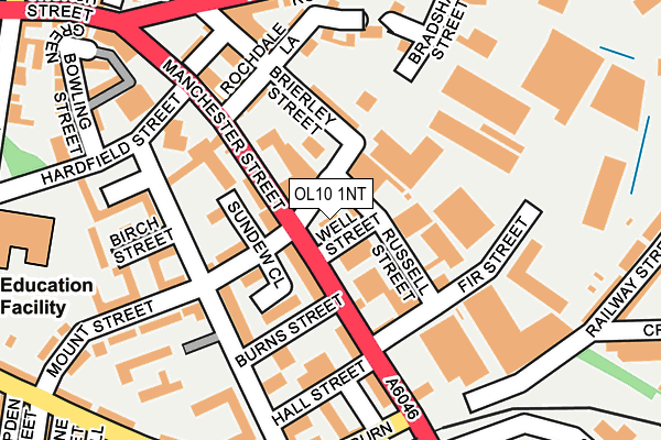
OL10 1NT is located in the North Heywood electoral ward, within the metropolitan district of Rochdale and the English Parliamentary constituency of Heywood and Middleton. The Sub Integrated Care Board (ICB) Location is NHS Greater Manchester ICB - 01D and the police force is Greater Manchester. This postcode has been in use since January 1992.


GetTheData
Source: OS OpenMap – Local (Ordnance Survey)
Source: OS VectorMap District (Ordnance Survey)
Licence: Open Government Licence (requires attribution)
| Easting | 386040 |
| Northing | 410500 |
| Latitude | 53.590890 |
| Longitude | -2.212373 |
GetTheData
Source: Open Postcode Geo
Licence: Open Government Licence
| Country | England |
| Postcode District | OL10 |
| ➜ OL10 open data dashboard ➜ See where OL10 is on a map ➜ Where is Heywood? | |
GetTheData
Source: Land Registry Price Paid Data
Licence: Open Government Licence
Elevation or altitude of OL10 1NT as distance above sea level:
| Metres | Feet | |
|---|---|---|
| Elevation | 130m | 427ft |
Elevation is measured from the approximate centre of the postcode, to the nearest point on an OS contour line from OS Terrain 50, which has contour spacing of ten vertical metres.
➜ How high above sea level am I? Find the elevation of your current position using your device's GPS.
GetTheData
Source: Open Postcode Elevation
Licence: Open Government Licence
| Ward | North Heywood |
| Constituency | Heywood And Middleton |
GetTheData
Source: ONS Postcode Database
Licence: Open Government Licence
| January 2022 | Violence and sexual offences | On or near Smith Street | 192m |
| September 2021 | Public order | On or near Cross Street | 349m |
| ➜ Get more crime data in our Crime section | |||
GetTheData
Source: data.police.uk
Licence: Open Government Licence
| Manchester St/Mount St (Manchester St) | Heywood | 40m |
| Manchester St/Hardfield St (Manchester St) | Heywood | 166m |
| Cowburn St (Wbd) (Cowburn Street) | Heywood | 195m |
| Manchester St/East Lancs Railway (Manchester St) | Heywood | 202m |
| Manchester St/Hardfield St (Manchester St) | Heywood | 210m |
| Heywood (East Lancashire Railway) | Heywood | 408m |
| Castleton (Manchester) Station | 2.3km |
| Rochdale Station | 4.5km |
| Mills Hill (Manchester) Station | 5.2km |
GetTheData
Source: NaPTAN
Licence: Open Government Licence
GetTheData
Source: ONS Postcode Database
Licence: Open Government Licence


➜ Get more ratings from the Food Standards Agency
GetTheData
Source: Food Standards Agency
Licence: FSA terms & conditions
| Last Collection | |||
|---|---|---|---|
| Location | Mon-Fri | Sat | Distance |
| Heywood Post Office | 409m | ||
| 22 Rochdale Road | 17:00 | 11:30 | 427m |
| Morrison's | 17:45 | 11:30 | 805m |
GetTheData
Source: Dracos
Licence: Creative Commons Attribution-ShareAlike
| Facility | Distance |
|---|---|
| Fitness Connection (Closed) Bethel Street, Heywood Health and Fitness Gym, Studio | 657m |
| Heywood Cricket Club Woodland Terrace, Heywood Grass Pitches | 821m |
| St Lukes C Of E Primary School Queens Park Road, Heywood Grass Pitches | 826m |
GetTheData
Source: Active Places
Licence: Open Government Licence
| School | Phase of Education | Distance |
|---|---|---|
| Harwood Park Primary School Hardfield Street, Heywood, OL10 1DG | Primary | 299m |
| St Luke's Church of England Primary School Queen's Park Road, Heywood, OL10 4XB | Primary | 822m |
| Hopwood Community Primary School Magdala Street, Heywood, OL10 2HN | Primary | 854m |
GetTheData
Source: Edubase
Licence: Open Government Licence
The below table lists the International Territorial Level (ITL) codes (formerly Nomenclature of Territorial Units for Statistics (NUTS) codes) and Local Administrative Units (LAU) codes for OL10 1NT:
| ITL 1 Code | Name |
|---|---|
| TLD | North West (England) |
| ITL 2 Code | Name |
| TLD3 | Greater Manchester |
| ITL 3 Code | Name |
| TLD37 | Greater Manchester North East |
| LAU 1 Code | Name |
| E08000005 | Rochdale |
GetTheData
Source: ONS Postcode Directory
Licence: Open Government Licence
The below table lists the Census Output Area (OA), Lower Layer Super Output Area (LSOA), and Middle Layer Super Output Area (MSOA) for OL10 1NT:
| Code | Name | |
|---|---|---|
| OA | E00027845 | |
| LSOA | E01005501 | Rochdale 018B |
| MSOA | E02001149 | Rochdale 018 |
GetTheData
Source: ONS Postcode Directory
Licence: Open Government Licence
| OL10 1NX | Russell Street | 21m |
| OL10 1PB | Manchester Street | 50m |
| OL10 1DL | Manchester Street | 77m |
| OL10 1FR | Sundew Close | 91m |
| OL10 1PJ | Bradshaw Street | 93m |
| OL10 1PH | Brierley Street | 104m |
| OL10 1NL | Manchester Street | 108m |
| OL10 1NW | Fir Street | 118m |
| OL10 1FS | Schofield Street | 121m |
| OL10 1PF | Rochdale Lane | 134m |
GetTheData
Source: Open Postcode Geo; Land Registry Price Paid Data
Licence: Open Government Licence