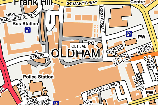
OL1 3AE is located in the Coldhurst electoral ward, within the metropolitan district of Oldham and the English Parliamentary constituency of Oldham West and Royton. The Sub Integrated Care Board (ICB) Location is NHS Greater Manchester ICB - 00Y and the police force is Greater Manchester. This postcode has been in use since January 1980.


GetTheData
Source: OS OpenMap – Local (Ordnance Survey)
Source: OS VectorMap District (Ordnance Survey)
Licence: Open Government Licence (requires attribution)
| Easting | 392536 |
| Northing | 405072 |
| Latitude | 53.542236 |
| Longitude | -2.114103 |
GetTheData
Source: Open Postcode Geo
Licence: Open Government Licence
| Country | England |
| Postcode District | OL1 |
| ➜ OL1 open data dashboard ➜ See where OL1 is on a map ➜ Where is Oldham? | |
GetTheData
Source: Land Registry Price Paid Data
Licence: Open Government Licence
Elevation or altitude of OL1 3AE as distance above sea level:
| Metres | Feet | |
|---|---|---|
| Elevation | 210m | 689ft |
Elevation is measured from the approximate centre of the postcode, to the nearest point on an OS contour line from OS Terrain 50, which has contour spacing of ten vertical metres.
➜ How high above sea level am I? Find the elevation of your current position using your device's GPS.
GetTheData
Source: Open Postcode Elevation
Licence: Open Government Licence
| Ward | Coldhurst |
| Constituency | Oldham West And Royton |
GetTheData
Source: ONS Postcode Database
Licence: Open Government Licence
| November 2021 | Other crime | On or near Eden Street | 412m |
| April 2021 | Violence and sexual offences | On or near Naylor Street | 294m |
| February 2021 | Violence and sexual offences | On or near Radcliffe Street | 436m |
| ➜ Get more crime data in our Crime section | |||
GetTheData
Source: data.police.uk
Licence: Open Government Licence
| Lord St/Post Office (Lord St) | Oldham | 109m |
| High St/Lord St (High St) | Oldham | 117m |
| High St/Town Square (High St) | Oldham | 130m |
| Lord St/Sports Ctr (Lord St) | Oldham | 136m |
| Lord St/Sports Ctr (Lord St) | Oldham | 146m |
| Oldham Central (Manchester Metrolink) (Union St) | Oldham | 254m |
| Oldham King Street (Manchester Metrolink) (King St) | Oldham | 362m |
| Oldham Mumps (Manchester Metrolink) (Mumps) | Oldham Mumps | 707m |
| Westwood (Manchester Metrolink) (Middleton Road) | Westwood | 780m |
| Derker (Manchester Metrolink) (Yates Street) | Derker | 1,180m |
| Mills Hill (Manchester) Station | 3.9km |
| Moston Station | 4.3km |
| Mossley (Manchester) Station | 5.7km |
GetTheData
Source: NaPTAN
Licence: Open Government Licence
GetTheData
Source: ONS Postcode Database
Licence: Open Government Licence


➜ Get more ratings from the Food Standards Agency
GetTheData
Source: Food Standards Agency
Licence: FSA terms & conditions
| Last Collection | |||
|---|---|---|---|
| Location | Mon-Fri | Sat | Distance |
| Old Town Hall | 18:30 | 10:30 | 216m |
| Old Town Hall | 18:30 | 11:30 | 217m |
| Oldham Delivery Office | 19:00 | 13:00 | 258m |
GetTheData
Source: Dracos
Licence: Creative Commons Attribution-ShareAlike
| Facility | Distance |
|---|---|
| Oldham Sports Centre (Closed) Lord Street, Oldham Sports Hall, Indoor Bowls, Swimming Pool, Health and Fitness Gym, Squash Courts | 206m |
| Oldham Leisure Centre Middleton Road, Oldham Swimming Pool, Health and Fitness Gym, Studio, Sports Hall, Indoor Bowls | 364m |
| Oldham College Rochdale Road, Oldham Health and Fitness Gym, Sports Hall, Artificial Grass Pitch, Outdoor Tennis Courts | 390m |
GetTheData
Source: Active Places
Licence: Open Government Licence
| School | Phase of Education | Distance |
|---|---|---|
| The Springboard Project 2 Medtia Square, Phoenix Street, Oldham, OL1 1AN | Not applicable | 348m |
| Future Finders Employability College 77 Union Street, Oldham, OL1 1JZ | Not applicable | 353m |
| The Oldham College Rochdale Road, Oldham, OL9 6AA | 16 plus | 390m |
GetTheData
Source: Edubase
Licence: Open Government Licence
The below table lists the International Territorial Level (ITL) codes (formerly Nomenclature of Territorial Units for Statistics (NUTS) codes) and Local Administrative Units (LAU) codes for OL1 3AE:
| ITL 1 Code | Name |
|---|---|
| TLD | North West (England) |
| ITL 2 Code | Name |
| TLD3 | Greater Manchester |
| ITL 3 Code | Name |
| TLD37 | Greater Manchester North East |
| LAU 1 Code | Name |
| E08000004 | Oldham |
GetTheData
Source: ONS Postcode Directory
Licence: Open Government Licence
The below table lists the Census Output Area (OA), Lower Layer Super Output Area (LSOA), and Middle Layer Super Output Area (MSOA) for OL1 3AE:
| Code | Name | |
|---|---|---|
| OA | E00027088 | |
| LSOA | E01005350 | Oldham 014B |
| MSOA | E02001111 | Oldham 014 |
GetTheData
Source: ONS Postcode Directory
Licence: Open Government Licence
| OL1 3AG | Curzon Street | 27m |
| OL1 3AJ | High Street | 53m |
| OL1 3BQ | Albion Street | 62m |
| OL1 3AA | Henshaw Street | 75m |
| OL1 3BG | Albion Street | 88m |
| OL1 1NH | Henshaw Street | 120m |
| OL1 1LF | Manchester Chambers | 140m |
| OL1 3AT | Church Terrace | 152m |
| OL1 1HP | Peter Street | 186m |
| OL1 2AD | Barker Street | 237m |
GetTheData
Source: Open Postcode Geo; Land Registry Price Paid Data
Licence: Open Government Licence