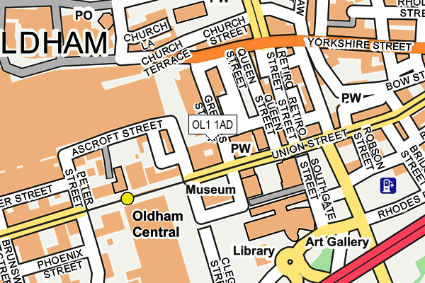
OL1 1AD is located in the Coldhurst electoral ward, within the metropolitan district of Oldham and the English Parliamentary constituency of Oldham West and Royton. The Sub Integrated Care Board (ICB) Location is NHS Greater Manchester ICB - 00Y and the police force is Greater Manchester. This postcode has been in use since August 1992.


GetTheData
Source: OS OpenMap – Local (Ordnance Survey)
Source: OS VectorMap District (Ordnance Survey)
Licence: Open Government Licence (requires attribution)
| Easting | 392764 |
| Northing | 404929 |
| Latitude | 53.540954 |
| Longitude | -2.110659 |
GetTheData
Source: Open Postcode Geo
Licence: Open Government Licence
| Country | England |
| Postcode District | OL1 |
| ➜ OL1 open data dashboard ➜ See where OL1 is on a map ➜ Where is Oldham? | |
GetTheData
Source: Land Registry Price Paid Data
Licence: Open Government Licence
Elevation or altitude of OL1 1AD as distance above sea level:
| Metres | Feet | |
|---|---|---|
| Elevation | 200m | 656ft |
Elevation is measured from the approximate centre of the postcode, to the nearest point on an OS contour line from OS Terrain 50, which has contour spacing of ten vertical metres.
➜ How high above sea level am I? Find the elevation of your current position using your device's GPS.
GetTheData
Source: Open Postcode Elevation
Licence: Open Government Licence
| Ward | Coldhurst |
| Constituency | Oldham West And Royton |
GetTheData
Source: ONS Postcode Database
Licence: Open Government Licence
| Yorkshire St/St Mary's Way (Yorkshire St) | Oldham | 139m |
| Yorkshire St/St Mary's Way (Yorkshire St) | Oldham | 152m |
| High St/Town Square (High St) | Oldham | 159m |
| High St/Lord St (High St) | Oldham | 168m |
| Yorkshire St/St Mary's Way (Yorkshire St) | Oldham | 183m |
| Oldham Central (Manchester Metrolink) (Union St) | Oldham | 127m |
| Oldham King Street (Manchester Metrolink) (King St) | Oldham | 460m |
| Oldham Mumps (Manchester Metrolink) (Mumps) | Oldham Mumps | 505m |
| Westwood (Manchester Metrolink) (Middleton Road) | Westwood | 1,019m |
| Derker (Manchester Metrolink) (Yates Street) | Derker | 1,152m |
| Mills Hill (Manchester) Station | 4.2km |
| Moston Station | 4.5km |
| Mossley (Manchester) Station | 5.4km |
GetTheData
Source: NaPTAN
Licence: Open Government Licence
GetTheData
Source: ONS Postcode Database
Licence: Open Government Licence


➜ Get more ratings from the Food Standards Agency
GetTheData
Source: Food Standards Agency
Licence: FSA terms & conditions
| Last Collection | |||
|---|---|---|---|
| Location | Mon-Fri | Sat | Distance |
| Old Town Hall | 18:30 | 11:30 | 101m |
| Old Town Hall | 18:30 | 10:30 | 103m |
| Eldon Street | 16:50 | 11:20 | 334m |
GetTheData
Source: Dracos
Licence: Creative Commons Attribution-ShareAlike
| Facility | Distance |
|---|---|
| Al'z Gym Bow Street, Oldham Health and Fitness Gym | 213m |
| Oldham Sports Centre (Closed) Lord Street, Oldham Sports Hall, Indoor Bowls, Swimming Pool, Health and Fitness Gym, Squash Courts | 306m |
| Mahdlo Youth Zone Egerton Street, Oldham Sports Hall, Studio | 375m |
GetTheData
Source: Active Places
Licence: Open Government Licence
| School | Phase of Education | Distance |
|---|---|---|
| Westwood Boys School 121 Union Street, Oldham, OL1 1TE | Not applicable | 201m |
| The Springboard Project 2 Medtia Square, Phoenix Street, Oldham, OL1 1AN | Not applicable | 288m |
| Future Finders Employability College 77 Union Street, Oldham, OL1 1JZ | Not applicable | 347m |
GetTheData
Source: Edubase
Licence: Open Government Licence
The below table lists the International Territorial Level (ITL) codes (formerly Nomenclature of Territorial Units for Statistics (NUTS) codes) and Local Administrative Units (LAU) codes for OL1 1AD:
| ITL 1 Code | Name |
|---|---|
| TLD | North West (England) |
| ITL 2 Code | Name |
| TLD3 | Greater Manchester |
| ITL 3 Code | Name |
| TLD37 | Greater Manchester North East |
| LAU 1 Code | Name |
| E08000004 | Oldham |
GetTheData
Source: ONS Postcode Directory
Licence: Open Government Licence
The below table lists the Census Output Area (OA), Lower Layer Super Output Area (LSOA), and Middle Layer Super Output Area (MSOA) for OL1 1AD:
| Code | Name | |
|---|---|---|
| OA | E00027524 | |
| LSOA | E01005434 | Oldham 024B |
| MSOA | E02001121 | Oldham 024 |
GetTheData
Source: ONS Postcode Directory
Licence: Open Government Licence
| OL1 1QN | Greaves Street | 65m |
| OL1 1PF | Union Street | 78m |
| OL1 1RD | Queen Street | 103m |
| OL1 1QX | Yorkshire Street | 114m |
| OL1 1SA | Retiro Street | 125m |
| OL1 1SB | Yorkshire Street | 133m |
| OL1 1RU | Union Street | 146m |
| OL1 1SQ | Waterloo Street | 148m |
| OL1 3AT | Church Terrace | 159m |
| OL1 1HP | Peter Street | 164m |
GetTheData
Source: Open Postcode Geo; Land Registry Price Paid Data
Licence: Open Government Licence